1950s Maps of Sterling, New York
Explore 6 historic maps of Sterling from the 1950s. These maps offer a rare glimpse into what life looked like during the 1950s — showing old roads, neighborhoods, homes, and landmarks that have changed or disappeared over time.
Whether you're researching your family's past, planning a metal detecting trip, or studying how Sterling's landscape evolved across the 1950s, these high-resolution maps are a powerful tool for exploring the history of this region.
- Focus on a specific era: All maps on this page are from the 1950s, giving you a focused view of this time period.
- See what’s changed: Compare century-old streets, trails, and buildings to today's modern landscape using overlays and satellite layers.
- Research with precision: Use these maps for genealogy, historical research, land use analysis, or educational projects.
- View, download, or print: Maps are fully viewable online in high resolution, and can be downloaded or printed for your own records.
Start exploring Sterling's history through authentic maps from the 1950s. This is your window into the past.
Sterling, NY maps
(6)- 1954 Map of Hannibal, 1955 Print
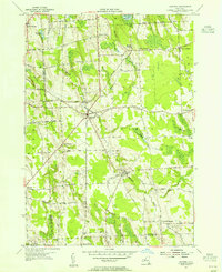 1954 Hannibal1955 Print · USGSThe Oswego and Cayuga County line comes alive in the mid-1950s, showing a landscape of rail-fed hamlets and agricultural crossroads. Researchers can trace family sites at Bethel Cem, follow the New York Central Railroad past Metcalf Siding, or explore small centers like Martville.2 unique versions available
 - 1954 Map of West Ninemile Point, 1955 Print
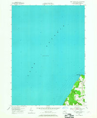 1954 West Ninemile Point1955 Print · USGSThe Cayuga County shoreline meets the deep waters of the lake in the mid-1950s, showing a quiet coastal landscape. You can trace the rural roads and early settlements like Moon Beach near the mouth of Ninemile Creek and West Ninemile Point.2 unique versions available
 - 1954 Map of Oswego West, 1955 Print
 1954 Oswego West1955 Print · USGSThe Lake Ontario shoreline near Oswego is captured here during the mid-fifties, showing the city's growth alongside its deep military and educational roots. Genealogists can locate family landmarks like the Irish Settlement, Rice Cemetery, and Saint Marys Chapel.4 unique versions available
 - 1954 Map of Fair Haven, 1956 Print
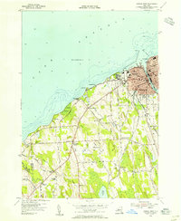
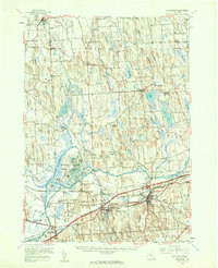
 1954 Fair Haven1956 Print · USGSCoastal Cayuga County meets the Great Lakes in the mid-fifties, showing a landscape of protected bays and rural crossroads. Local historians can locate ancestral sites like McArthur Cem or trace the early paths of Sterling Sta and the Marine Railway.3 unique versions available
 - 1954 Map of Victory, 1956 Print
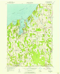
 1954 Victory1956 Print · USGSThe rural border of Wayne and Cayuga counties is captured here in the mid-fifties, showing a landscape shaped by glacial drumlins. Researchers can locate the Schuler Farms Landing Field, several rural cemeteries like French Cem, and the waters of Duck Lake.
 - 1954 Map of Weedsport, 1961 Print
 1954 Weedsport1961 Print · USGSMid-century Cayuga County is captured here as the new thruway begins to reshape the historic canal and rail corridor. Researchers can trace the legacy of the Erie Canal and New York Central through Port Byron, or locate family landmarks like Brick Ch and Schuler Farms Airfield.3 unique versions available
End of results
Showing maps 1-6 of 6
Top cities near Sterling
- Lysander historical maps
- Oswego historical maps
- Van Buren historical maps
- Fulton historical maps
- Oswego historical maps
- Scriba historical maps
See more
Top neighborhoods of Sterling
- Martville historical maps
- Fintches Corners historical maps
- Moon Beach historical maps
- North Victory historical maps
- Sterling Valley historical maps
- Crocketts historical maps
See more
Frequently asked questions
- What are the different types of historical maps available for Sterling?
- What is the oldest map of Sterling?
- Where can I purchase historical maps of Sterling for my home or office?
- Where can I download high-res historical maps of Sterling?
- Are there historical topographic maps available for Sterling?
- Is there historical aerial imagery available for Sterling?
- Where are historical maps of Sterling sourced from?