1940s Maps of Throop, New York
Explore 4 historic maps of Throop from the 1940s. These maps offer a rare glimpse into what life looked like during the 1940s — showing old roads, neighborhoods, homes, and landmarks that have changed or disappeared over time.
Whether you're researching your family's past, planning a metal detecting trip, or studying how Throop's landscape evolved across the 1940s, these high-resolution maps are a powerful tool for exploring the history of this region.
- Focus on a specific era: All maps on this page are from the 1940s, giving you a focused view of this time period.
- See what’s changed: Compare century-old streets, trails, and buildings to today's modern landscape using overlays and satellite layers.
- Research with precision: Use these maps for genealogy, historical research, land use analysis, or educational projects.
- View, download, or print: Maps are fully viewable online in high resolution, and can be downloaded or printed for your own records.
Start exploring Throop's history through authentic maps from the 1940s. This is your window into the past.
Throop, NY maps
(4)- 1943 Map of Montezuma
 1943 Montezuma1943 Print · USGSThe Cayuga County marshlands are captured here during the Second World War as the region’s massive river and canal systems were being managed for conservation. You can trace the early path of the Erie Canal (Abandoned) or find family sites near Port Byron and Murray Cem.
 - 1943 Map of Cayuga
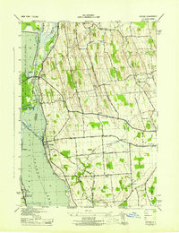 1943 Cayuga1943 Print · USGSThe northern reaches of Cayuga Lake and the Montezuma wetlands are captured here during the early 1940s. Genealogists can locate family-named landmarks like Farnam Cem and Polk Corners, alongside the tracks of the New York Central Railroad.
 - 1943 Map of Weedsport
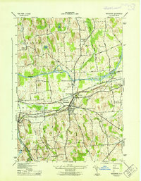 1943 Weedsport1943 Print · USGSMid-century Cayuga County is defined by its deep layering of transport history as the modern Barge Canal replaces the original Erie route. Researchers can trace the transition between eras at the Weedsport Canal Terminal and the Erie Canal (Abandoned), or locate family sites like La Due Cem and Brick Church.
 - 1943 Map of Auburn
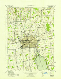 1943 Auburn1943 Print · USGSMid-century Auburn and its lakefront were defined by a mix of heavy industry and institutional landmarks during the war years. Genealogists and researchers can trace local family history through numerous rural burial grounds like Soule Cem and schools such as Seward Sch.
End of results
Showing maps 1-4 of 4
Top cities near Throop
- Auburn historical maps
- Lysander historical maps
- Van Buren historical maps
- Seneca Falls historical maps
- Waterloo historical maps
- Skaneateles historical maps
See more
Top neighborhoods of Throop
Frequently asked questions
- What are the different types of historical maps available for Throop?
- What is the oldest map of Throop?
- Where can I purchase historical maps of Throop for my home or office?
- Where can I download high-res historical maps of Throop?
- Are there historical topographic maps available for Throop?
- Is there historical aerial imagery available for Throop?
- Where are historical maps of Throop sourced from?