1950s Maps of Chautauqua County, New York
Explore 28 historic maps of Chautauqua County from the 1950s. These maps offer a rare glimpse into what life looked like during the 1950s — showing old roads, neighborhoods, homes, and landmarks that have changed or disappeared over time.
Whether you're researching your family's past, planning a metal detecting trip, or studying how Chautauqua County's landscape evolved across the 1950s, these high-resolution maps are a powerful tool for exploring the history of this region.
- Focus on a specific era: All maps on this page are from the 1950s, giving you a focused view of this time period.
- See what’s changed: Compare century-old streets, trails, and buildings to today's modern landscape using overlays and satellite layers.
- Research with precision: Use these maps for genealogy, historical research, land use analysis, or educational projects.
- View, download, or print: Maps are fully viewable online in high resolution, and can be downloaded or printed for your own records.
Start exploring Chautauqua County's history through authentic maps from the 1950s. This is your window into the past.
Chautauqua County, NY maps
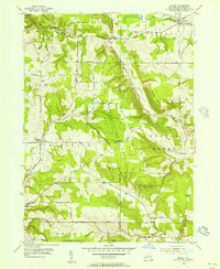
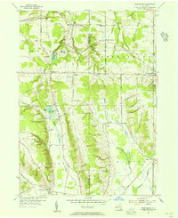
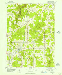
(28)- 1954 Map of Kennedy, 1955 Print
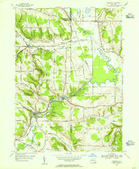 1954 Kennedy1955 Print · USGSThe Chautauqua and Cattaraugus county line comes alive in the mid-fifties, showing a landscape shaped by the Erie RR and Conewango Creek. Researchers can trace ancestral locations like Schermerhorn Corners, Poland Center, and several old burial grounds including Pioneer Cem.3 unique versions available
 - 1954 Map of Russell, 1956 Print
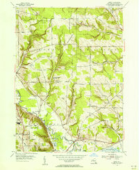
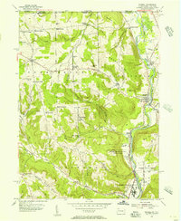 1954 Russell1956 Print · USGSWarren County in the mid-1950s shows a landscape of institutional farms and rural crossroads along the Conewango Creek. Trace the New York Central Railroad corridor through Russell and Akeley, or locate ancestral sites like Marshtown Cem and Putnamville.4 unique versions available
 - 1954 Map of Chautauqua, 1956 Print
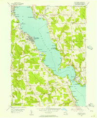 1954 Chautauqua1956 Print · USGSThe mid-century resort and educational character of the lake is captured here just as post-war recreation reached its peak. Genealogists and historians can trace family locations through Wild Rose Cem or explore landmarks like the Amphitheater and the Pennsylvania RR.3 unique versions available
 - 1954 Map of Ellery Center, 1956 Print
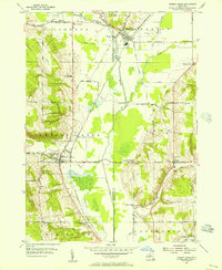
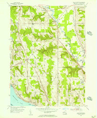 1954 Ellery Center1956 Print · USGSChautauqua County in the mid-fifties is captured here as a mix of lakeside landings and upland farming hamlets. Genealogists and local historians can trace family-named roads and landmarks like Kimball Stand, Phillips Mills, and the Jamestown Speedway.5 unique versions available
 - 1954 Map of Hamlet, 1956 Print
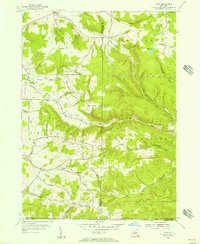
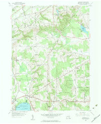
 1954 Hamlet1956 Print · USGSChautauqua County's rural townships and reforestation areas are documented here in the mid-fifties. Researchers can locate small communities like Sinclairville and Hamlet, alongside family landmarks such as Luce Hill Cem and Burnham Hollow.2 unique versions available
 - 1954 Map of Gerry, 1956 Print
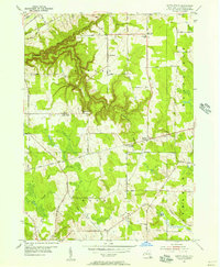
 1954 Gerry1956 Print · USGSThe townships of Gerry and Ellington are captured here in the mid-1950s as traditional farming landscapes met postwar growth. Genealogists can trace family landmarks like Ross Mills Cem, Dean Sch, and the old Erie RR line.4 unique versions available
 - 1954 Map of Scandia, 1956 Print
 1954 Scandia1956 Print · USGSThe Pennsylvania and New York borderlands come alive in this midcentury survey of the hills north of Warren. Local historians can trace the foundations of Scandia, find family plots at Seven Dolors Cem, and locate the sprawling grounds of the Warren State Hospital.3 unique versions available
 - 1954 Map of Jamestown, 1956 Print
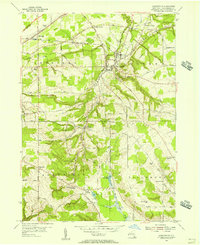
 1954 Jamestown1956 Print · USGSJamestown and its neighboring valleys in the mid-fifties show a bustling industrial center transitioning into Chautauqua County farmland. Researchers can trace family roots through numerous sites like Mt Olivet Cem, Lillian Dickson Sch, and the outlying hamlet of Frewsburg.3 unique versions available
 - 1954 Map of Forestville, 1956 Print
 1954 Forestville1956 Print · USGSChautauqua County rural life is captured here in the mid-fifties, just as the modern turnpike began to reshape the landscape. Genealogists can trace family names at Chicken Tavern Corners, Pioneer Cem, and several district schools.3 unique versions available
 - 1954 Map of South Ripley, 1956 Print
 1954 South Ripley1956 Print · USGSWestern Chautauqua County is captured here in the mid-fifties, showing a rural landscape of upland farms and deep ravines before the expansion of modern highways. Genealogists can trace family-named routes like Tanner Road to settlements at South Ripley and Mina.3 unique versions available
 - 1954 Map of Ivory, 1956 Print
 1954 Ivory1956 Print · USGSThe rural borderlands between Chautauqua and Cattaraugus Counties are captured here in the mid-1950s. Genealogists can trace family footprints through sites like Oak Hill Cem, Wheeler Hill Ch, and the small settlement of Ivory.4 unique versions available
 - 1954 Map of Cherry Creek, 1956 Print
 1954 Cherry Creek1956 Print · USGSMid-century Chautauqua and Cattaraugus Counties are captured here just as the rural school system and railroad economy were consolidating. Researchers can locate family landmarks at Kings School Corner, trace the Erie RR through South Dayton, or find the Union Cem near Leon.3 unique versions available
 - 1954 Map of Perrysburg, 1956 Print
 1954 Perrysburg1956 Print · USGSChautauqua County in the mid-fifties is seen here through its network of small hamlets and the critical Erie RR line. Genealogists can trace family names through landmarks like Wrights Corners, Villenova Cem, and School No 1.4 unique versions available
 - 1954 Map of Dunkirk, 1956 Print
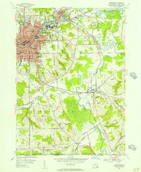
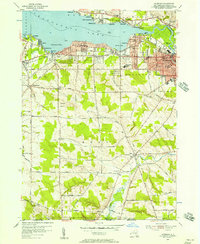
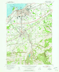 1954 Dunkirk1956 Print · USGSCoastal industry and inland college life meet along Lake Erie in the mid-fifties as the Thruway begins to reshape the Chautauqua County landscape. Researchers can locate Union Station, the State University Teachers College, and numerous historic burial grounds like Willowbrook Cem.3 unique versions available
 - 1954 Map of Brocton, 1956 Print
 1954 Brocton1956 Print · USGSThe Chautauqua County shoreline was in a state of rapid change during the mid-fifties as the Thruway cut through established farmland. Researchers can trace family roots through the Pecor Cem or locate vintage landmarks like the Drive-in Theater and Van Buren Sch.2 unique versions available
 - 1954 Map of Hartfield, 1956 Print
 1954 Hartfield1956 Print · USGSMid-century Chautauqua County is captured here at the head of the lake, showing the rural crossroads and rail lines that connected these upland farms. Genealogists can trace family sites near Evergreen Cem, Coes Corners, and the Howard Hill Ch.2 unique versions available
 - 1954 Map of Ripley, 1956 Print
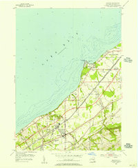
 1954 Ripley1956 Print · USGSThe Chautauqua County shoreline in the mid-fifties shows the arrival of the New York State Thruway alongside historic lakefront communities. Trace the development of Ripley and Forsyth or locate family roots near the Quincy Rural Cem and Ripley Beach.2 unique versions available
 - 1954 Map of Panama, 1957 Print
 1954 Panama1957 Print · USGSChautauqua County in the mid-fifties shows a landscape of reforestation and lakeside living along Chautauqua Lake. Researchers can trace the Erie Railroad through Watts Flats and Niobe, or locate family sites like Greenwood Cem and Union Cem.2 unique versions available
 - 1954 Map of Clymer, 1957 Print
 1954 Clymer1957 Print · USGSChautauqua County in the mid-fifties presents a landscape of dairy farms and rural hamlets connected by narrow valley roads. Researchers can trace family history through sites like Marks Corners Cem, Edwards Chapel, and the shoreline settlements of Findley Lake.3 unique versions available
 - 1954 Map of North Clymer, 1957 Print
 1954 North Clymer1957 Print · USGSThe dairy lands of Chautauqua County appear here in the mid-1950s, as rural settlements and railroads still define the local economy. Researchers can trace family homesteads along Petit Road, locate the old Panama Sta along the Pennsylvania Railroad, or find the Clymer Hill Ch.3 unique versions available
 - 1954 Map of Sherman, 1957 Print
 1954 Sherman1957 Print · USGSSouthwestern Chautauqua County in the mid-fifties is defined by the rail corridor and dairy lands surrounding Sherman. Genealogists and historians can trace family road names and locate rural landmarks like Slab City, Porter Cem, and the RR Sta.3 unique versions available
 - 1954 Map of Lakewood, 1957 Print
 1954 Lakewood1957 Print · USGSMid-century Chautauqua Lake life is captured here during a time of lakeside growth and rural continuity. Genealogists and local researchers can trace the Erie Railroad route through Celoron or locate family sites like Bentley Cem and the village of Busti.3 unique versions available
 - 1954 Map of Cassadaga, 1957 Print
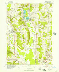 1954 Cassadaga1957 Print · USGSMid-century Chautauqua County life centers on the waters of Lily Dale and Cassadaga as the new central school rises. Genealogists can trace family names at Greenwood Cemetery, explore the hamlets of Stockton and Kabob, or follow the New York Central rail line.3 unique versions available
 - 1954 Map of Westfield, 1957 Print
 1954 Westfield1957 Print · USGSWestfield and the Chautauqua lakefront are captured here in the mid-fifties, just as the New York State Thruway was being carved through the landscape. Genealogists and local historians can locate the Old St James Cemetery, the Drive-in Theater, and the lakeside docks at Barcelona.5 unique versions available
 - 1955 Map of North Of Dunkirk, 1956 Print
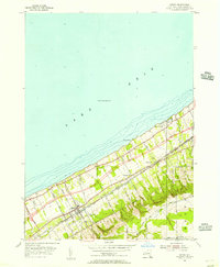
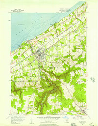
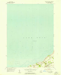 1955 North Of Dunkirk1956 Print · USGSThe Lake Erie shoreline in the mid-1950s reveals a bustling intersection of rail and water transport between Dunkirk and Sheridan. Researchers can trace the heavy industrial footprint of the New York Central and locate local landmarks like the Dunkirk Conference Grounds.3 unique versions available
Showing maps 1-25 of 28
Top cities of Chautauqua County
- Jamestown historical maps
- Pomfret historical maps
- Dunkirk historical maps
- Ellicott historical maps
- Busti historical maps
- Hanover historical maps
See more
Frequently asked questions
- What are the different types of historical maps available for Chautauqua County?
- What is the oldest map of Chautauqua County?
- Where can I purchase historical maps of Chautauqua County for my home or office?
- Where can I download high-res historical maps of Chautauqua County?
- Are there historical topographic maps available for Chautauqua County?
- Is there historical aerial imagery available for Chautauqua County?
- Where are historical maps of Chautauqua County sourced from?