2020s Maps of Chautauqua County, New York
Explore 36 historic maps of Chautauqua County from the 2020s. These maps offer a rare glimpse into what life looked like during the 2020s — showing old roads, neighborhoods, homes, and landmarks that have changed or disappeared over time.
Whether you're researching your family's past, planning a metal detecting trip, or studying how Chautauqua County's landscape evolved across the 2020s, these high-resolution maps are a powerful tool for exploring the history of this region.
- Focus on a specific era: All maps on this page are from the 2020s, giving you a focused view of this time period.
- See what’s changed: Compare century-old streets, trails, and buildings to today's modern landscape using overlays and satellite layers.
- Research with precision: Use these maps for genealogy, historical research, land use analysis, or educational projects.
- View, download, or print: Maps are fully viewable online in high resolution, and can be downloaded or printed for your own records.
Start exploring Chautauqua County's history through authentic maps from the 2020s. This is your window into the past.
Chautauqua County, NY maps
(36)- 2023 Map of Wattsburg, 2023 Print
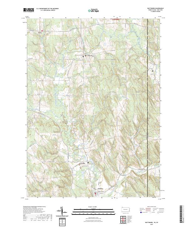 2023 Wattsburg2023 Print · USGSCrossing the Pennsylvania and New York border, this modern topographic study captures the rural hamlets and glacial terrain of Erie and Chautauqua counties. Genealogists can locate family burial sites like the Old Miller Burial Ground and Lowville Cem near the banks of the West Branch French Creek.
 - 2023 Map of North East OE N, 2023 Print
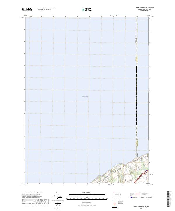 2023 North East OE N2023 Print · USGSThe Pennsylvania and New York border reaches the shoreline of Lake Erie in this recent survey of the coastal corridor. Researchers can trace the path of Twenty-mile Creek and the route of the Great Lakes Seaway Trail as they cross the state line.
 - 2023 Map of Ivory, 2023 Print
 2023 Ivory2023 Print · USGSWestern New York's ridge-and-valley landscape is documented here in the 2020s, showing the enduring rural layout of the Chautauqua borderlands. Genealogists and hikers can trace the winding paths of Frews Run or locate quiet landmarks like Ivory Cemetery and the settlement of Vollentine.
 - 2023 Map of South Ripley, 2023 Print
 2023 South Ripley2023 Print · USGSChautauqua County’s upland farm country is captured here during the early twenty-first century as the landscape maintains its traditional rural character. Researchers can trace family sites near South Ripley Cem or locate the unique Pratt's Eastern Divide Airport and the waters of Gage Gulf.
 - 2023 Map of Cassadaga, 2023 Print
 2023 Cassadaga2023 Print · USGSThe Chautauqua County lake district is captured here in the early twenty-first century, showing the enduring character of historic spiritualist and summer colonies. Genealogists can locate family sites across several rural burying grounds including Bachelor Cem and Picketts Corner Cem near the villages of Cassadaga and Lily Dale.
 - 2023 Map of Clymer, 2023 Print
 2023 Clymer2023 Print · USGSSouthwestern Chautauqua County is captured here in the 2020s, showing a landscape of quiet hamlets and glacial lakes near the Pennsylvania border. Researchers can trace local lineage through Findley Lake Cem, Holland Cem, and the rural crossroads of Morgan Corners.
 - 2023 Map of Perrysburg, 2023 Print
 2023 Perrysburg2023 Print · USGSThe Chautauqua and Cattaraugus county line divides this rural landscape as it appeared in the early 2020s. Genealogists can locate several historic burial grounds, such as Perrysburg Cem and Cottage Cem, alongside small hamlets like Smith Mills and Nashville.
 - 2023 Map of North of Dunkirk, 2023 Print
 2023 North of Dunkirk2023 Print · USGSThe eastern edge of Dunkirk and its Lake Erie shoreline are shown here in modern detail. Researchers can trace local landmarks like Saint Hyacinth Cem and the routes of Scott Creek and Beaver Creek as they meet the lake.
 - 2023 Map of Westfield, 2023 Print
 2023 Westfield2023 Print · USGSThe Lake Erie shoreline and the Chautauqua highlands meet in this contemporary survey of the Westfield area. Genealogists can locate several burial sites including Union Cem and Saint James Cem, while tracing the historic corridor from Barcelona to Mayville.
 - 2023 Map of North Clymer, 2023 Print
 2023 North Clymer2023 Print · USGSChautauqua County's rural character is well-preserved in this study of the hills and hollows surrounding the Clymer area. Genealogists can trace family lines through several local burial grounds, including Clymer Hill Cem, Town Line Cem, and the quiet crossroads at Jaquins.
 - 2023 Map of Jamestown, 2023 Print
 2023 Jamestown2023 Print · USGSJamestown and the Chautauqua County valley corridors are captured here in the early 2020s, showing a landscape defined by its waterways. Researchers can trace local genealogy and land use across sites like Stillwater Cem, Laska Airport, and the Conewango Creek Water Trail.
 - 2023 Map of Sherman, 2023 Print
 2023 Sherman2023 Print · USGSWestern Chautauqua County is captured here in the early 2020s, showing a landscape of traditional dairy country and quiet hamlets. Researchers can trace family history through the Sherman Cem or explore early routes like the Old Gibbs Road Trl near Summerdale.
 - 2023 Map of Ripley, 2023 Print
 2023 Ripley2023 Print · USGSThe Chautauqua County shoreline comes into focus in this contemporary survey of the western New York coastal corridor. You can trace family lineages at the Quincy Rural Cem or explore the settlement patterns along the historic Lake Road near Shore Haven and Forsyth.
 - 2023 Map of Hartfield, 2023 Print
 2023 Hartfield2023 Print · USGSChautauqua County's northern hills and lakefront are documented here in the early twenty-first century. Researchers can trace land patterns near the Chautauqua Lake shoreline at Hartfield or locate family roots at Evergreen Cem and Pleasantville Cem.
 - 2023 Map of Forestville, 2023 Print
 2023 Forestville2023 Print · USGSChautauqua County’s upland terrain and creek valleys are captured in this modern survey of the Forestville area. Researchers can locate ancestral sites at Sheridan Pioneer Cem, Abbey Cem, and the crossroads of Black Corners.
 - 2023 Map of Westfield OE N, 2023 Print
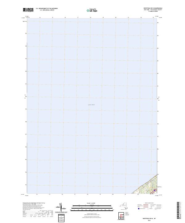 2023 Westfield OE N2023 Print · USGSThe Chautauqua County shoreline meets the expanse of the Great Lakes in the early 2020s. Genealogists and local historians can trace the modern coastal infrastructure along the edge of Lake Erie, including local thoroughfares like E Lake Rd.
 - 2023 Map of Kennedy, 2023 Print
 2023 Kennedy2023 Print · USGSThe border of Chautauqua and Cattaraugus Counties comes to life here in the early twenty-first century. Genealogists can locate family burial sites at Riverside Cem and Pioneer Cem while tracing the winding path of Conewango Creek.
 - 2023 Map of North East, 2023 Print
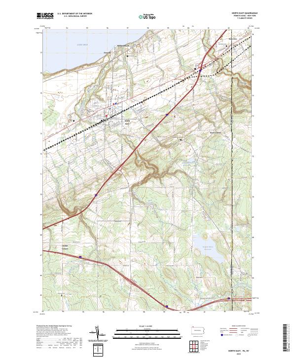 2023 North East2023 Print · USGSThe Lake Erie shoreline in the early 2020s shows a landscape of established lakeside communities and vital water resources. Researchers can trace family plots at North East Cem or Phillips Cem and locate historic crossroads like Kerrs Corners.
 - 2023 Map of Russell, 2023 Print
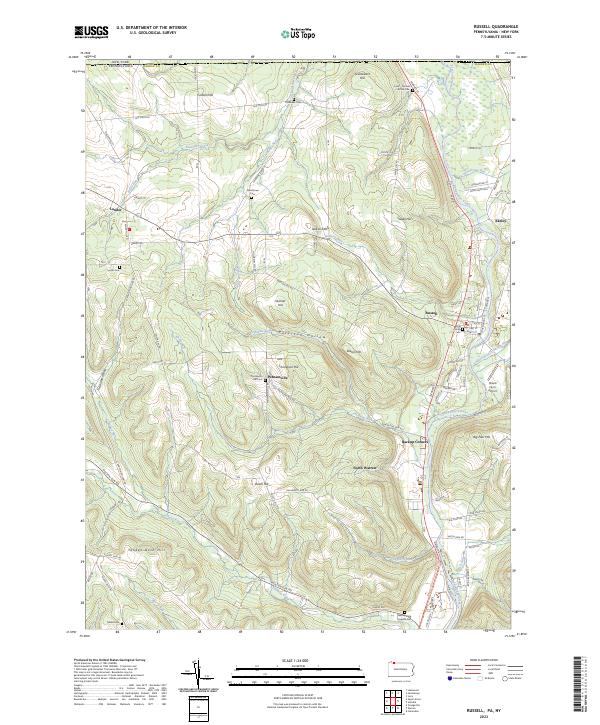 2023 Russell2023 Print · USGSWarren County at the New York border showcases a landscape of ridge-top farms and creek-side hamlets. Researchers can trace family history through several rural burial grounds like Marshtown Cem or explore the settlement patterns of Russell and Akeley along the Conewango Creek.
 - 2023 Map of Columbus, 2023 Print
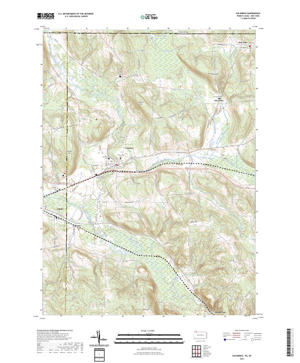 2023 Columbus2023 Print · USGSThe rural valleys of Warren County appear here during the early twenty-first century, centered on the historic crossroads of Columbus. Genealogists can locate family sites at Saint John Cem or trace the old paths of Plank Rd and Brokenstraw Creek.
 - 2023 Map of Lottsville, 2023 Print
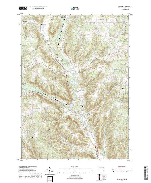 2023 Lottsville2023 Print · USGSNorthwestern Pennsylvania at the New York border remains defined by its rural creek valleys and historic family settlements. Genealogists can trace local lineages through several burial sites like Tuttle Hill Cem and Bear Lake Cem near the banks of Little Brokenstraw Creek.
 - 2023 Map of Corry, 2023 Print
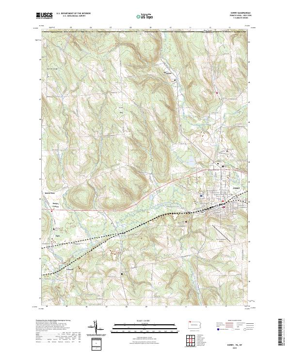 2023 Corry2023 Print · USGSThe Pennsylvania and New York border country comes alive in this contemporary record of the Upper French Creek valley. Genealogists can trace family names through rural landmarks like McCray Cem and Saint Thomas Cem, or explore the crossroads at Ranges Corners and Lovell.
 - 2023 Map of Union City, 2023 Print
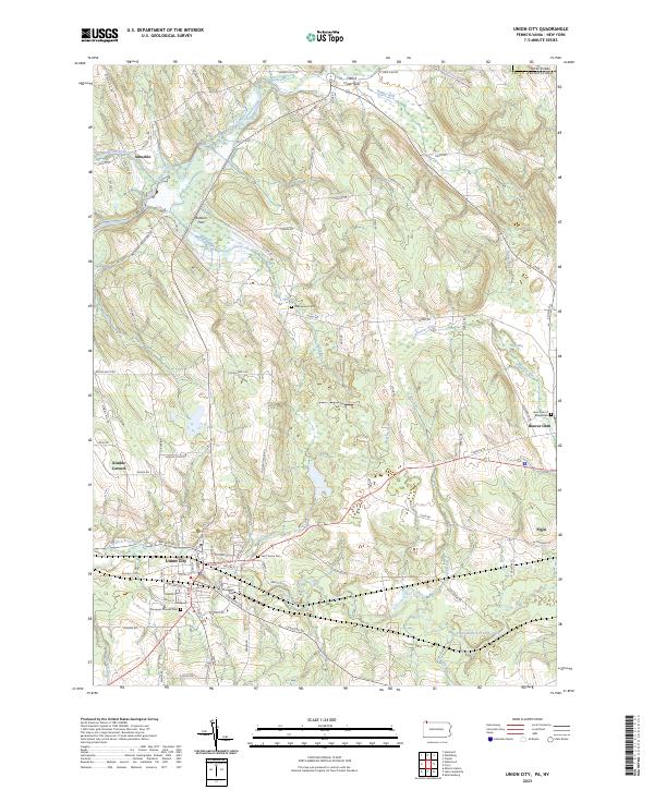 2023 Union City2023 Print · USGSThe Erie County countryside near Union City comes into focus in this contemporary survey of the Pennsylvania-New York borderlands. Researchers can locate several burial sites including Thompson Pioneer Cem and Lawn Cem of Beaverdam, alongside rural settlements like Elgin and Arbuckle.
 - 2023 Map of Sugar Grove, 2023 Print
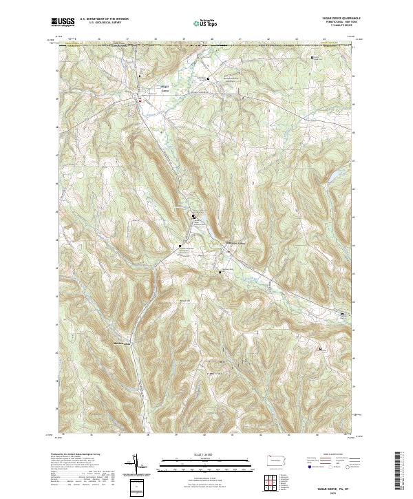 2023 Sugar Grove2023 Print · USGSNorthern Warren County's valley settlements and family-named ridges are shown in high detail as they appeared in the 2020s. Genealogists can trace burial sites from the Robert Miles Gravesite to the Jackson Run Cem.
 - 2023 Map of Scandia, 2023 Print
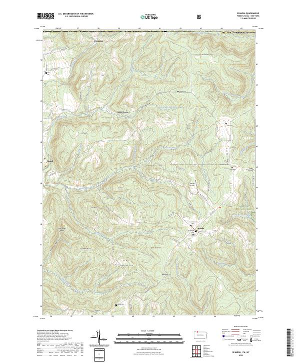 2023 Scandia2023 Print · USGSWarren County, Pennsylvania, is shown here as a landscape of deep valleys and forested ridges during the early twenty-first century. Researchers can locate numerous family-named burial grounds like Macks Corners Cem and Smith Cem alongside landmarks such as Scandia Air Park.
Showing maps 1-25 of 36
Top cities of Chautauqua County
- Jamestown historical maps
- Pomfret historical maps
- Dunkirk historical maps
- Ellicott historical maps
- Busti historical maps
- Hanover historical maps
See more
Frequently asked questions
- What are the different types of historical maps available for Chautauqua County?
- What is the oldest map of Chautauqua County?
- Where can I purchase historical maps of Chautauqua County for my home or office?
- Where can I download high-res historical maps of Chautauqua County?
- Are there historical topographic maps available for Chautauqua County?
- Is there historical aerial imagery available for Chautauqua County?
- Where are historical maps of Chautauqua County sourced from?