1950s Maps of Ellicott, New York
Explore 4 historic maps of Ellicott from the 1950s. These maps offer a rare glimpse into what life looked like during the 1950s — showing old roads, neighborhoods, homes, and landmarks that have changed or disappeared over time.
Whether you're researching your family's past, planning a metal detecting trip, or studying how Ellicott's landscape evolved across the 1950s, these high-resolution maps are a powerful tool for exploring the history of this region.
- Focus on a specific era: All maps on this page are from the 1950s, giving you a focused view of this time period.
- See what’s changed: Compare century-old streets, trails, and buildings to today's modern landscape using overlays and satellite layers.
- Research with precision: Use these maps for genealogy, historical research, land use analysis, or educational projects.
- View, download, or print: Maps are fully viewable online in high resolution, and can be downloaded or printed for your own records.
Start exploring Ellicott's history through authentic maps from the 1950s. This is your window into the past.
Ellicott, NY maps
(4)- 1954 Map of Ellery Center, 1956 Print
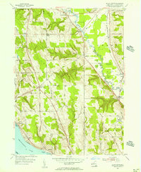 1954 Ellery Center1956 Print · USGSChautauqua County in the mid-fifties is captured here as a mix of lakeside landings and upland farming hamlets. Genealogists and local historians can trace family-named roads and landmarks like Kimball Stand, Phillips Mills, and the Jamestown Speedway.5 unique versions available
 - 1954 Map of Gerry, 1956 Print
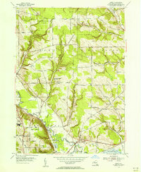 1954 Gerry1956 Print · USGSThe townships of Gerry and Ellington are captured here in the mid-1950s as traditional farming landscapes met postwar growth. Genealogists can trace family landmarks like Ross Mills Cem, Dean Sch, and the old Erie RR line.4 unique versions available
 - 1954 Map of Jamestown, 1956 Print
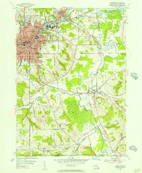 1954 Jamestown1956 Print · USGSJamestown and its neighboring valleys in the mid-fifties show a bustling industrial center transitioning into Chautauqua County farmland. Researchers can trace family roots through numerous sites like Mt Olivet Cem, Lillian Dickson Sch, and the outlying hamlet of Frewsburg.3 unique versions available
 - 1954 Map of Lakewood, 1957 Print
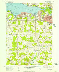 1954 Lakewood1957 Print · USGSMid-century Chautauqua Lake life is captured here during a time of lakeside growth and rural continuity. Genealogists and local researchers can trace the Erie Railroad route through Celoron or locate family sites like Bentley Cem and the village of Busti.3 unique versions available
End of results
Showing maps 1-4 of 4
Top cities near Ellicott
- Jamestown historical maps
- Pomfret historical maps
- Busti historical maps
- Portland historical maps
- Ellery historical maps
- Chautauqua historical maps
See more
Top neighborhoods of Ellicott
- Bonila historical maps
- Levant historical maps
- Ross Mills historical maps
- Fluvanna historical maps
- Elmhurst historical maps
- Jamestown West historical maps
See more
Frequently asked questions
- What are the different types of historical maps available for Ellicott?
- What is the oldest map of Ellicott?
- Where can I purchase historical maps of Ellicott for my home or office?
- Where can I download high-res historical maps of Ellicott?
- Are there historical topographic maps available for Ellicott?
- Is there historical aerial imagery available for Ellicott?
- Where are historical maps of Ellicott sourced from?