1950s Maps of Pomfret, New York
Explore 4 historic maps of Pomfret from the 1950s. These maps offer a rare glimpse into what life looked like during the 1950s — showing old roads, neighborhoods, homes, and landmarks that have changed or disappeared over time.
Whether you're researching your family's past, planning a metal detecting trip, or studying how Pomfret's landscape evolved across the 1950s, these high-resolution maps are a powerful tool for exploring the history of this region.
- Focus on a specific era: All maps on this page are from the 1950s, giving you a focused view of this time period.
- See what’s changed: Compare century-old streets, trails, and buildings to today's modern landscape using overlays and satellite layers.
- Research with precision: Use these maps for genealogy, historical research, land use analysis, or educational projects.
- View, download, or print: Maps are fully viewable online in high resolution, and can be downloaded or printed for your own records.
Start exploring Pomfret's history through authentic maps from the 1950s. This is your window into the past.
Pomfret, NY maps
(4)- 1954 Map of Dunkirk, 1956 Print
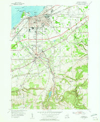 1954 Dunkirk1956 Print · USGSCoastal industry and inland college life meet along Lake Erie in the mid-fifties as the Thruway begins to reshape the Chautauqua County landscape. Researchers can locate Union Station, the State University Teachers College, and numerous historic burial grounds like Willowbrook Cem.3 unique versions available
 - 1954 Map of Brocton, 1956 Print
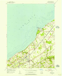 1954 Brocton1956 Print · USGSThe Chautauqua County shoreline was in a state of rapid change during the mid-fifties as the Thruway cut through established farmland. Researchers can trace family roots through the Pecor Cem or locate vintage landmarks like the Drive-in Theater and Van Buren Sch.2 unique versions available
 - 1954 Map of Hartfield, 1956 Print
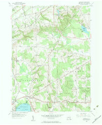 1954 Hartfield1956 Print · USGSMid-century Chautauqua County is captured here at the head of the lake, showing the rural crossroads and rail lines that connected these upland farms. Genealogists can trace family sites near Evergreen Cem, Coes Corners, and the Howard Hill Ch.2 unique versions available
 - 1954 Map of Cassadaga, 1957 Print
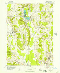 1954 Cassadaga1957 Print · USGSMid-century Chautauqua County life centers on the waters of Lily Dale and Cassadaga as the new central school rises. Genealogists can trace family names at Greenwood Cemetery, explore the hamlets of Stockton and Kabob, or follow the New York Central rail line.3 unique versions available
End of results
Showing maps 1-4 of 4
Top cities near Pomfret
- Dunkirk historical maps
- Fredonia historical maps
- Hanover historical maps
- Westfield historical maps
- Portland historical maps
- Ellery historical maps
See more
Top neighborhoods of Pomfret
- Shumla historical maps
- Laona historical maps
- Reed Corners historical maps
- Van Buren Bay historical maps
- Lamberton historical maps
- Lily Dale historical maps
See more
Frequently asked questions
- What are the different types of historical maps available for Pomfret?
- What is the oldest map of Pomfret?
- Where can I purchase historical maps of Pomfret for my home or office?
- Where can I download high-res historical maps of Pomfret?
- Are there historical topographic maps available for Pomfret?
- Is there historical aerial imagery available for Pomfret?
- Where are historical maps of Pomfret sourced from?