1950s Maps of Stockton, New York
Explore 4 historic maps of Stockton from the 1950s. These maps offer a rare glimpse into what life looked like during the 1950s — showing old roads, neighborhoods, homes, and landmarks that have changed or disappeared over time.
Whether you're researching your family's past, planning a metal detecting trip, or studying how Stockton's landscape evolved across the 1950s, these high-resolution maps are a powerful tool for exploring the history of this region.
- Focus on a specific era: All maps on this page are from the 1950s, giving you a focused view of this time period.
- See what’s changed: Compare century-old streets, trails, and buildings to today's modern landscape using overlays and satellite layers.
- Research with precision: Use these maps for genealogy, historical research, land use analysis, or educational projects.
- View, download, or print: Maps are fully viewable online in high resolution, and can be downloaded or printed for your own records.
Start exploring Stockton's history through authentic maps from the 1950s. This is your window into the past.
Stockton, NY maps
(4)- 1954 Map of Chautauqua, 1956 Print
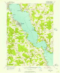 1954 Chautauqua1956 Print · USGSThe mid-century resort and educational character of the lake is captured here just as post-war recreation reached its peak. Genealogists and historians can trace family locations through Wild Rose Cem or explore landmarks like the Amphitheater and the Pennsylvania RR.3 unique versions available
 - 1954 Map of Ellery Center, 1956 Print
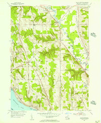 1954 Ellery Center1956 Print · USGSChautauqua County in the mid-fifties is captured here as a mix of lakeside landings and upland farming hamlets. Genealogists and local historians can trace family-named roads and landmarks like Kimball Stand, Phillips Mills, and the Jamestown Speedway.5 unique versions available
 - 1954 Map of Hartfield, 1956 Print
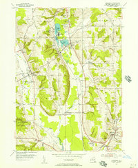
 1954 Hartfield1956 Print · USGSMid-century Chautauqua County is captured here at the head of the lake, showing the rural crossroads and rail lines that connected these upland farms. Genealogists can trace family sites near Evergreen Cem, Coes Corners, and the Howard Hill Ch.2 unique versions available
 - 1954 Map of Cassadaga, 1957 Print
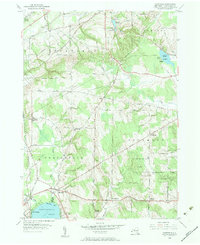
 1954 Cassadaga1957 Print · USGSMid-century Chautauqua County life centers on the waters of Lily Dale and Cassadaga as the new central school rises. Genealogists can trace family names at Greenwood Cemetery, explore the hamlets of Stockton and Kabob, or follow the New York Central rail line.3 unique versions available
End of results
Showing maps 1-4 of 4
Top cities near Stockton
- Jamestown historical maps
- Pomfret historical maps
- Dunkirk historical maps
- Fredonia historical maps
- Ellicott historical maps
- Busti historical maps
See more
Top neighborhoods of Stockton
- Kabob historical maps
- Moons historical maps
- South Stockton historical maps
- Denton Corners historical maps
- Centralia historical maps
- Cassadaga historical maps
Frequently asked questions
- What are the different types of historical maps available for Stockton?
- What is the oldest map of Stockton?
- Where can I purchase historical maps of Stockton for my home or office?
- Where can I download high-res historical maps of Stockton?
- Are there historical topographic maps available for Stockton?
- Is there historical aerial imagery available for Stockton?
- Where are historical maps of Stockton sourced from?