1950s Maps of Villenova, New York
Explore 4 historic maps of Villenova from the 1950s. These maps offer a rare glimpse into what life looked like during the 1950s — showing old roads, neighborhoods, homes, and landmarks that have changed or disappeared over time.
Whether you're researching your family's past, planning a metal detecting trip, or studying how Villenova's landscape evolved across the 1950s, these high-resolution maps are a powerful tool for exploring the history of this region.
- Focus on a specific era: All maps on this page are from the 1950s, giving you a focused view of this time period.
- See what’s changed: Compare century-old streets, trails, and buildings to today's modern landscape using overlays and satellite layers.
- Research with precision: Use these maps for genealogy, historical research, land use analysis, or educational projects.
- View, download, or print: Maps are fully viewable online in high resolution, and can be downloaded or printed for your own records.
Start exploring Villenova's history through authentic maps from the 1950s. This is your window into the past.
Villenova, NY maps
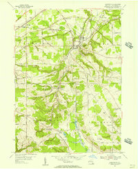
(4)- 1954 Map of Hamlet, 1956 Print
 1954 Hamlet1956 Print · USGSChautauqua County's rural townships and reforestation areas are documented here in the mid-fifties. Researchers can locate small communities like Sinclairville and Hamlet, alongside family landmarks such as Luce Hill Cem and Burnham Hollow.2 unique versions available
 - 1954 Map of Forestville, 1956 Print
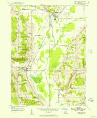
 1954 Forestville1956 Print · USGSChautauqua County rural life is captured here in the mid-fifties, just as the modern turnpike began to reshape the landscape. Genealogists can trace family names at Chicken Tavern Corners, Pioneer Cem, and several district schools.3 unique versions available
 - 1954 Map of Cherry Creek, 1956 Print
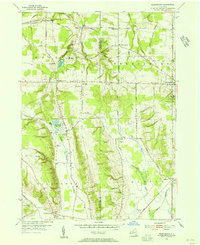
 1954 Cherry Creek1956 Print · USGSMid-century Chautauqua and Cattaraugus Counties are captured here just as the rural school system and railroad economy were consolidating. Researchers can locate family landmarks at Kings School Corner, trace the Erie RR through South Dayton, or find the Union Cem near Leon.3 unique versions available
 - 1954 Map of Perrysburg, 1956 Print
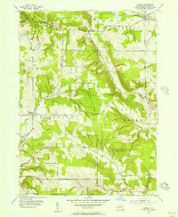
 1954 Perrysburg1956 Print · USGSChautauqua County in the mid-fifties is seen here through its network of small hamlets and the critical Erie RR line. Genealogists can trace family names through landmarks like Wrights Corners, Villenova Cem, and School No 1.4 unique versions available
End of results
Showing maps 1-4 of 4
Top cities near Villenova
- Evans historical maps
- Pomfret historical maps
- Dunkirk historical maps
- Fredonia historical maps
- Ellicott historical maps
- Eden historical maps
See more
Top neighborhoods of Villenova
Frequently asked questions
- What are the different types of historical maps available for Villenova?
- What is the oldest map of Villenova?
- Where can I purchase historical maps of Villenova for my home or office?
- Where can I download high-res historical maps of Villenova?
- Are there historical topographic maps available for Villenova?
- Is there historical aerial imagery available for Villenova?
- Where are historical maps of Villenova sourced from?