1950s Maps of Claverack, New York
Explore 7 historic maps of Claverack from the 1950s. These maps offer a rare glimpse into what life looked like during the 1950s — showing old roads, neighborhoods, homes, and landmarks that have changed or disappeared over time.
Whether you're researching your family's past, planning a metal detecting trip, or studying how Claverack's landscape evolved across the 1950s, these high-resolution maps are a powerful tool for exploring the history of this region.
- Focus on a specific era: All maps on this page are from the 1950s, giving you a focused view of this time period.
- See what’s changed: Compare century-old streets, trails, and buildings to today's modern landscape using overlays and satellite layers.
- Research with precision: Use these maps for genealogy, historical research, land use analysis, or educational projects.
- View, download, or print: Maps are fully viewable online in high resolution, and can be downloaded or printed for your own records.
Start exploring Claverack's history through authentic maps from the 1950s. This is your window into the past.
Claverack, NY maps
(7)- 1953 Map of Stottville, 1955 Print
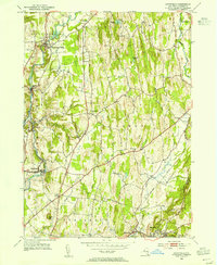 1953 Stottville1955 Print · USGSColumbia County at mid-century reveals a landscape shaped by early American history and the valley's industrial waterways. Genealogists and historians can trace family roots through the Martin Van Buren Homestead, the Ichabod Crane Home, and landmarks like Brick Tavern.3 unique versions available
 - 1953 Map of Hudson North, 1955 Print
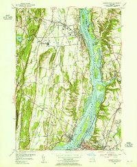 1953 Hudson North1955 Print · USGSThe Hudson Valley in the early fifties shows a landscape defined by its riverfront industry and deep-rooted settlements. Genealogists and local historians can trace family locations near Riverside Cem, the Rossman Sch, or the historic docks of Athens and Newton Hook.3 unique versions available
 - 1953 Map of Chatham, 1955 Print
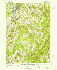 1953 Chatham1955 Print · USGSColumbia County in the early fifties shows a transition from rail-dependent industry to a quiet rural landscape. Genealogists can locate family landmarks like Arnolds Mill, Moorhouse Corner, and the German Cem near Harlemville.5 unique versions available
 - 1953 Map of Hillsdale, 1955 Print
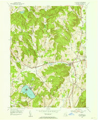 1953 Hillsdale1955 Print · USGSColumbia County at the mid-century reveals a landscape of high ridges and railroad-centered hamlets like Craryville and Hillsdale. Genealogists and local historians can trace the New York Central line and find rural landmarks like Drum Church and Williams Cem.3 unique versions available
 - 1956 Map of Albany, 1968 Print
 1956 Albany1968 Print · USGSThe industrial heart of the Northeast is revealed in the mid-1950s, from the Hudson Valley to the Connecticut River. Researchers can trace the legacy of the Quabbin Reservoir, locate Westover Air Force Base, or follow the Rutland RR through the Green Mountains.2 unique versions available
 - 1957 Map of Albany
 1957 Albany1957 Print · USGSThe Tri-State region and Connecticut River Valley are captured here during a period of significant postwar growth and infrastructure expansion. Genealogists and historians can trace the rail-and-river economy through landmarks like the Boston and Maine railroad, Quabbin Reservoir, and Westover Air Force Base.
 - 1959 Map of Albany
 1959 Albany1959 Print · USGSThe Hudson and Connecticut River valleys are captured here during the late fifties, showing the region's dense rail networks and massive water projects. Researchers can trace the New York State Thruway or locate local landmarks like Mt Greylock and the Quabbin Reservoir.
End of results
Showing maps 1-7 of 7
Top cities near Claverack
- Catskill historical maps
- Red Hook historical maps
- Coxsackie historical maps
- Kinderhook historical maps
- Coeymans historical maps
- Hudson historical maps
See more
Top neighborhoods of Claverack
- Mellenville historical maps
- Hollowville historical maps
- Martindale historical maps
- Churchtown historical maps
- Brick Tavern historical maps
- Red Mills historical maps
See more
Frequently asked questions
- What are the different types of historical maps available for Claverack?
- What is the oldest map of Claverack?
- Where can I purchase historical maps of Claverack for my home or office?
- Where can I download high-res historical maps of Claverack?
- Are there historical topographic maps available for Claverack?
- Is there historical aerial imagery available for Claverack?
- Where are historical maps of Claverack sourced from?