1980s Maps of Copake, New York
Explore 4 historic maps of Copake from the 1980s. These maps offer a rare glimpse into what life looked like during the 1980s — showing old roads, neighborhoods, homes, and landmarks that have changed or disappeared over time.
Whether you're researching your family's past, planning a metal detecting trip, or studying how Copake's landscape evolved across the 1980s, these high-resolution maps are a powerful tool for exploring the history of this region.
- Focus on a specific era: All maps on this page are from the 1980s, giving you a focused view of this time period.
- See what’s changed: Compare century-old streets, trails, and buildings to today's modern landscape using overlays and satellite layers.
- Research with precision: Use these maps for genealogy, historical research, land use analysis, or educational projects.
- View, download, or print: Maps are fully viewable online in high resolution, and can be downloaded or printed for your own records.
Start exploring Copake's history through authentic maps from the 1980s. This is your window into the past.
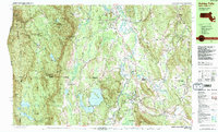
Copake, NY maps
(4)- 1980 Map of Hillsdale, 1981 Print
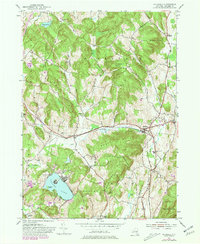 1980 Hillsdale1981 Print · USGSThe hills of Columbia County are captured here in the early eighties, showing a landscape defined by dairy country and growing summer retreats. Genealogists can locate family-named sites like Crum Cem and Collins Cem, or trace the New York Central rail line.
 - 1986 Map of Pittsfield
 1986 Pittsfield1986 Print · USGSThe Berkshires and the Hudson Valley meet in the mid-1980s, documenting a cross-border landscape of mountain forests and river towns. Genealogists and historians can trace the paths of Conrail and the Taconic State Parkway as they pass through Stockbridge, Great Barrington, and Kinderhook.2 unique versions available
 - 1987 Map of Ashley Falls
 1987 Ashley Falls1987 Print · USGSThe tri-state border region of the Berkshires comes to life in the late eighties, showing the deep valleys of the Housatonic River and the high ridges of the Mount Washington State Forest. Genealogists and hikers can trace the Appalachian Trail past Mt Everett or locate local landmarks like Union Ch and the historic settlement of Sodom.2 unique versions available
 - 1987 Map of Great Barrington, 1988 Print
 1987 Great Barrington1988 Print · USGSThe Berkshires in the late eighties show a sophisticated blend of town life and conservation, centered on the Housatonic River valley. Genealogists and local researchers can pinpoint historical landmarks like the Battlesite Mon, the Simons Rock Early College campus, and local neighborhoods such as Berkshire Heights.
End of results
Showing maps 1-4 of 4
Top cities near Copake
- Kinderhook historical maps
- Great Barrington historical maps
- Claverack historical maps
- Hudson historical maps
- Ghent historical maps
- Lenox historical maps
See more
Top neighborhoods of Copake
- West Copake historical maps
- Copake Lake historical maps
- Taconic Shores historical maps
- Hamlet of Copake historical maps
- Copake Falls historical maps
Frequently asked questions
- What are the different types of historical maps available for Copake?
- What is the oldest map of Copake?
- Where can I purchase historical maps of Copake for my home or office?
- Where can I download high-res historical maps of Copake?
- Are there historical topographic maps available for Copake?
- Is there historical aerial imagery available for Copake?
- Where are historical maps of Copake sourced from?