1900-1909 Maps of Cuyler, New York
Explore 3 historic maps of Cuyler from 1900-1909. These maps offer a rare glimpse into what life looked like during the 1900s — showing old roads, neighborhoods, homes, and landmarks that have changed or disappeared over time.
Whether you're researching your family's past, planning a metal detecting trip, or studying how Cuyler's landscape evolved across the 1900s, these high-resolution maps are a powerful tool for exploring the history of this region.
- Focus on a specific era: All maps on this page are from the 1900s, giving you a focused view of this time period.
- See what’s changed: Compare century-old streets, trails, and buildings to today's modern landscape using overlays and satellite layers.
- Research with precision: Use these maps for genealogy, historical research, land use analysis, or educational projects.
- View, download, or print: Maps are fully viewable online in high resolution, and can be downloaded or printed for your own records.
Start exploring Cuyler's history through authentic maps from the 1900s. This is your window into the past.
Cuyler, NY maps
(3)- 1900 Map of Tully
 1900 Tully1900 Print · USGSIn the hills south of Syracuse during the late 1890s, this area supported a network of dairy farms and rail-dependent hamlets. Genealogists can locate long-lost rural communities like Maple Grove (Case P.O.), the Onondaga Indian Reservation, and the resort grounds at Assembly Park.9 unique versions available
 - 1903 Map of Cortland
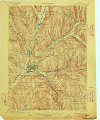 1903 Cortland1903 Print · USGSCortland County at the turn of the century was a bustling hub of rail activity and river-valley industry. Researchers can trace the early layout of Cortland and Homer, or locate vanished operations at Crains Mills and Blodgett Mills.7 unique versions available
 - 1904 Map of Pitcher
 1904 Pitcher1904 Print · USGSThe rural highlands of Central New York are documented here at the turn of the century, showing a landscape of upland hamlets and river-valley rail lines. Genealogists can trace early homesteads near Pitcher, Cincinnatus, and the remote heights of Taylor Center.5 unique versions available
End of results
Showing maps 1-3 of 3
Top cities near Cuyler
- Onondaga historical maps
- Cortland historical maps
- Cortlandville historical maps
- Pompey historical maps
- Cazenovia historical maps
- Homer historical maps
See more
Top neighborhoods of Cuyler
- Cuyler Hill historical maps
- New Boston historical maps
- Tripoli historical maps
- Keeney historical maps
- Cowles Settlement historical maps
Frequently asked questions
- What are the different types of historical maps available for Cuyler?
- What is the oldest map of Cuyler?
- Where can I purchase historical maps of Cuyler for my home or office?
- Where can I download high-res historical maps of Cuyler?
- Are there historical topographic maps available for Cuyler?
- Is there historical aerial imagery available for Cuyler?
- Where are historical maps of Cuyler sourced from?