1940s Maps of Delaware County, New York
Explore 48 historic maps of Delaware County from the 1940s. These maps offer a rare glimpse into what life looked like during the 1940s — showing old roads, neighborhoods, homes, and landmarks that have changed or disappeared over time.
Whether you're researching your family's past, planning a metal detecting trip, or studying how Delaware County's landscape evolved across the 1940s, these high-resolution maps are a powerful tool for exploring the history of this region.
- Focus on a specific era: All maps on this page are from the 1940s, giving you a focused view of this time period.
- See what’s changed: Compare century-old streets, trails, and buildings to today's modern landscape using overlays and satellite layers.
- Research with precision: Use these maps for genealogy, historical research, land use analysis, or educational projects.
- View, download, or print: Maps are fully viewable online in high resolution, and can be downloaded or printed for your own records.
Start exploring Delaware County's history through authentic maps from the 1940s. This is your window into the past.
Delaware County, NY maps
(48)- 1943 Map of Honesdale
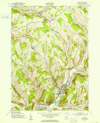
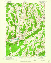
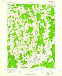
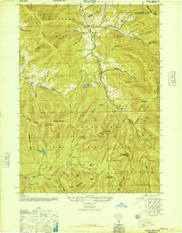
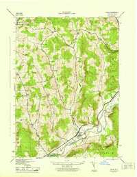
 1943 Honesdale1943 Print · USGSThe northern Poconos and the Upper Delaware River valley appear here during the early war years, showing a network of mountain hamlets and riverfront rail towns. Genealogists can trace family roots through numerous remote institutions like Kingsbury Hill Church, Peakville P O, and the Hiawatha School.
 - 1943 Map of Delhi, 1953 Print
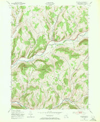
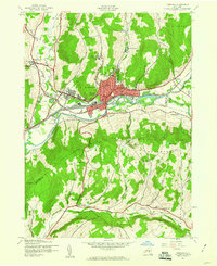
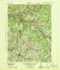
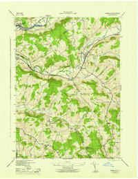
 1943 Delhi1953 Print · USGSMid-century Delaware County comes to life as a network of river valleys and upland turnpikes during the height of the steam-to-diesel rail transition. Genealogists can locate family sites near Woodland Cem, the County Home, and numerous numbered schoolhouses like School No 5.3 unique versions available
 - 1943 Map of Bloomville, 1953 Print
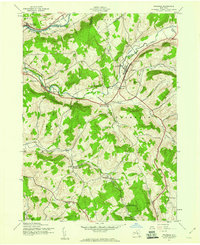
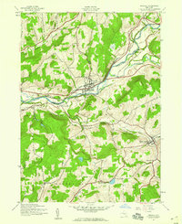
 1943 Bloomville1953 Print · USGSDelaware County dairy country appears at a mid-century peak, centered on the West Branch Delaware River valley. Genealogists and local historians can trace family roots through numerous upland sites like Pink St Sch and the Riverside Cem.3 unique versions available
 - 1943 Map of Sidney, 1953 Print
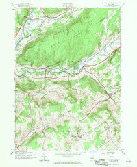
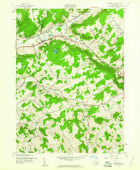
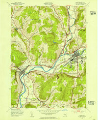 1943 Sidney1953 Print · USGSThe Susquehanna and Unadilla rivers meet during the mid-forties, carving a landscape defined by industrial rail lines and valley settlements. Genealogists can trace family roots through Greenlawn Cem, the village of Bainbridge, and the junction at Sidney.3 unique versions available
 - 1943 Map of Charlotteville, 1960 Print
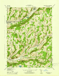
 1943 Charlotteville1960 Print · USGSOtsego and Schoharie counties appear here in the 1940s, showing a landscape of upland ridges and valley hamlets linked by the Delaware and Hudson rail line. Genealogists can trace family locations near Post Cem, Lutheranville, and several rural schoolhouses like Hollenbeck Sch.4 unique versions available
 - 1943 Map of Franklin, 1960 Print
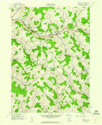
 1943 Franklin1960 Print · USGSDelaware County farmland and valley villages are captured here during the 1940s, when the railroad still linked the hollows. Researchers can trace the New York and Ontario Western line to stops like Franklin Depot and Woodford (Northfield Station).4 unique versions available
 - 1943 Map of Schenevus, 1960 Print
 1943 Schenevus1960 Print · USGSThe valleys of Otsego County were defined by rail and water during the 1940s. Genealogists and historians can trace the rural landscape through several numbered schoolhouses, the Delaware and Hudson line, and family sites like Maple Grove Cem.4 unique versions available
 - 1943 Map of Oneonta, 1960 Print
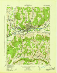
 1943 Oneonta1960 Print · USGSOneonta and the Susquehanna River valley are captured in the 1940s when the city flourished as a regional education and railroad center. Genealogists can trace family names and local landmarks through several rural sites including Ouleout Ch, Plains Cem, and Homer Folks State Hospital.6 unique versions available
 - 1943 Map of Unadilla, 1960 Print
 1943 Unadilla1960 Print · USGSThe Susquehanna River valley in the early 1940s was a hub for the Delaware and Hudson railroad and rural village life. Researchers can find precise locations for Highland Cem, the Sidney Center station, and district landmarks like School No 12.4 unique versions available
 - 1943 Map of West Davenport, 1960 Print
 1943 West Davenport1960 Print · USGSDelaware County and Otsego County are captured here during the wartime years, showing a landscape defined by valley railroads and rural school districts. Genealogists can locate family landmarks like McMinn Cem, the Prosser Hollow Sch, and the rail junction at Colliersville.3 unique versions available
 - 1943 Map of Otego, 1960 Print
 1943 Otego1960 Print · USGSOtsego County's rural uplands and river valleys are captured here during the mid-1940s as the rail-and-river economy persisted in villages like Otego. Genealogists can locate family landmarks including Burdick Cem, Otego Ch, and the Perry Sch.3 unique versions available
 - 1943 Map of Davenport, 1960 Print
 1943 Davenport1960 Print · USGSDelaware County during the 1940s is defined by its rural valley settlements and the essential New York Central rail corridor. Genealogists can trace family roots through upland landmarks like Kortright Center, Fergusonville, and the Covenanter Cem.3 unique versions available
 - 1943 Map of Treadwell, 1960 Print
 1943 Treadwell1960 Print · USGSDelaware County upland communities are captured in the early 1940s as the rural schoolhouse era remained in full swing. Genealogists can locate family sites near Croton Union Cem or trace ancestor routes through Poverty Hollow and West Delhi.3 unique versions available
 - 1943 Map of Monticello, 1964 Print
 1943 Monticello1964 Print · USGSSullivan County in the early 1940s is shown at a peak of its rural development before mid-century modernization changed the landscape. Genealogists and researchers can trace local roots through numerous district schools like the Bushville School and family landmarks such as the Stewart Cem or the industrial Dye Works.
 - 1944 Map of Long Eddy
 1944 Long Eddy1944 Print · USGSThe Delaware River valley straddles the state line during the mid-forties, showing a landscape of isolated hill farms and riverside rail towns. Researchers can locate numerous vanished country schools such as Priceville Sch and Cooley Sch or trace the path of the Erie RR.
 - 1944 Map of Deposit
 1944 Deposit1944 Print · USGSDelaware and Broome Counties come alive in the mid-1940s, showing the river-valley communities before later reservoir projects transformed the landscape. Trace genealogical roots through dozens of rural landmarks like McClure Settlement, Rock Royal, and Hale Eddy.
 - 1944 Map of Livingston Manor
 1944 Livingston Manor1944 Print · USGSThe Catskill foothills of Sullivan County are mapped here during the mid-forties, showing the vital rail and river corridor through Livingston Manor. Genealogists and local historians can trace the New York Ontario and Western RR and numerous rural schoolhouses like Hardenburgh Sch and Midway Sch.
 - 1945 Map of West Davenport
 1945 West Davenport1945 Print · USGSThe Susquehanna and Charlotte Creek valleys are captured here at a mid-century peak of rail and rural development. Genealogists can trace family names at Newell Cem and Charlotte Valley Cem or locate the many one-room schoolhouses like Coe Hill School.
 - 1945 Map of Seager
 1945 Seager1945 Print · USGSThe high peaks and deep valleys of the Catskills appear here at the end of World War II, showing a landscape defined by forest and stream. Genealogists and hikers can trace old landmarks like School No 4, the Baker Cem, and the Balsam Lookout Tower.5 unique versions available
 - 1945 Map of Sidney
 1945 Sidney1945 Print · USGSThe Susquehanna and Unadilla rivers meet in this mid-century view of the Tri-County area. Genealogists and historians can trace the rail lines through Sidney or locate landmarks like Greenlawn Cem and the Landing Field.
 - 1945 Map of Franklin
 1945 Franklin1945 Print · USGSThe rural hills of Delaware County are captured here just after the war, showcasing a landscape of upland dairying and rail-dependent hamlets. Genealogists can locate family landmarks like Barnes Cem, Wells Bridge School No 6, and the New York Ontario and Western Railroad corridor.
 - 1945 Map of Oneonta
 1945 Oneonta1945 Print · USGSOneonta and the Susquehanna River valley are shown here in the mid-1940s as a bustling junction of rail lines and higher education. Genealogists and local researchers can trace the early layouts of Hartwick College, St Marys Cem, and rural outposts like Ouleout.
 - 1945 Map of Treadwell
 1945 Treadwell1945 Print · USGSMid-century Delaware County is captured here at a time when small schoolhouses still anchored every rural hollow. Genealogists and historians can trace the foundations of local life at Treadwell, Croton Union Cem, and the Freer Hollow School.
 - 1945 Map of Charlotteville
 1945 Charlotteville1945 Print · USGSThe hill country of Otsego and Schoharie counties comes into focus during the mid-forties, showing a landscape of upland farms and valley railroads. Genealogists can locate family landmarks like Snooks Cem, Dugway Cem, and old district sites such as Mud Lake Sch.
 - 1945 Map of Otego
 1945 Otego1945 Print · USGSThe Susquehanna River valley in the 1940s is shown here at high detail, centered on the village of Otego and its rail connections. Researchers can locate numerous family burial grounds like Evergreen Cem and Quackenbush Cem or rural landmarks like Perry School.
Showing maps 1-25 of 48
Top cities of Delaware County
- Sidney historical maps
- Walton historical maps
- Delhi historical maps
- Middletown historical maps
- Davenport historical maps
- Hancock historical maps
See more
Frequently asked questions
- What are the different types of historical maps available for Delaware County?
- What is the oldest map of Delaware County?
- Where can I purchase historical maps of Delaware County for my home or office?
- Where can I download high-res historical maps of Delaware County?
- Are there historical topographic maps available for Delaware County?
- Is there historical aerial imagery available for Delaware County?
- Where are historical maps of Delaware County sourced from?