Old Maps of Delaware County, New York for Metal Detecting
Plan your next treasure hunt with 331 historic maps of Delaware County. Find old homesites, ghost towns, trails, and gathering spots that may be lost to time — perfect for identifying promising metal detecting locations.
- Locate forgotten sites: Uncover places like long-lost settlements, abandoned rail lines, or gathering spots.
- Plan better hunts: Use map overlays combined with LiDAR or satellite views to narrow in on historically rich areas.
- Made for detectorists: Thousands of hobbyists use these maps to discover relics, coins, and hidden history.
Use these historic maps to boost your research and find new opportunities beneath the surface of Delaware County.
Delaware County, NY maps
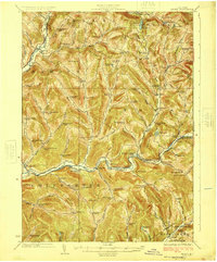
(331)- 1900 Map of Phoenicia, 1963 Print
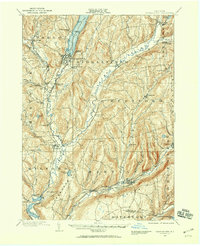
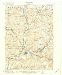
 1900 Phoenicia1963 Print · USGSThe high Catskills at the turn of the century are captured here in a moment of emerging tourism and mountain settlement. Genealogists and hikers can trace the original locations of the Grand Hotel, the remote Winnisook Lodge, and the rail stops at Mt Pleasant Station.
 - 1901 Map of Margaretville, 1961 Print
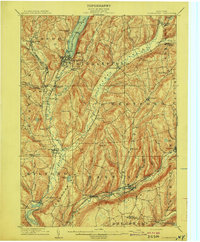
 1901 Margaretville1961 Print · USGSThe Catskills at the turn of the century are defined here by river-valley settlements and the Ulster and Delaware railroad line. Genealogists and historians can trace family-named hollows and vanished settlements like Grant Mills, Arena, and Griffin Corners.
 - 1901 Map of Gilboa, 1961 Print
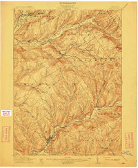
 1901 Gilboa1961 Print · USGSThe northern Catskills at the start of the twentieth century reveal a landscape of river-valley hamlets and high mountain peaks. Genealogists and historians can trace original homesteads near Gilboa, Prattsville, and Livingstonville, or find landmarks like Pratt Rocks.
 - 1903 Map of Gilboa
 1903 Gilboa1903 Print · USGSThe Schoharie Valley at the turn of the century shows a landscape of clustered hamlets and prominent mountain peaks before major regional changes. Researchers can trace the layout of early settlements like Gilboa and Prattsville, or locate family landmarks such as Pratt Rocks and Manorkill Falls.9 unique versions available
 - 1903 Map of Phoenicia
 1903 Phoenicia1903 Print · USGSThe Catskills come alive at the turn of the century, showing the mountain rail corridor and early grand resorts. Researchers can trace the Ulster and Delaware line through Phoenicia to the Highmount Grand Hotel and Winnisook Lodge.9 unique versions available
 - 1904 Map of Richmondville
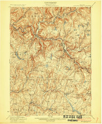
 1904 Richmondville1904 Print · USGSSchoharie and Otsego counties appear here at the start of the century as the rail-and-river economy reached its peak. Genealogists can trace family footprints through historic hamlets like Lutheranville, Seward, and South Valley along the Delaware and Hudson RR.5 unique versions available
 - 1904 Map of Hobart
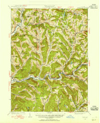
 1904 Hobart1904 Print · USGSThe northern Catskills and Delaware River headwaters come to life in this study of the region just after the turn of the century. You can trace the Ulster and Delaware rail line through high-elevation settlements like Stamford, Hobart, and Roxbury.5 unique versions available
 - 1904 Map of Margaretville
 1904 Margaretville1904 Print · USGSThe Catskills' high-valley communities thrive along the Ulster and Delaware RR at the turn of the century. Trace old family farmsteads and rural mountain hamlets like Arena, New Kingston, and Griffin Corners as they appeared in 1904.7 unique versions available
 - 1907 Map of Cooperstown, 1960 Print
 1907 Cooperstown1960 Print · USGSOtsego County at the start of the twentieth century remains centered on its historic waterways and early rail corridors. Genealogists can trace family names through landmarks like Hartwick Seminary, Phoenix Mills, and the Lakewood Cemetery near the lake shore.
 - 1909 Map of Cooperstown
 1909 Cooperstown1909 Print · USGSOtsego County at the start of the twentieth century shows a landscape of deep valleys shaped by the Susquehanna and rail travel. Genealogists can trace family names and early sites like Hartwick Seminary, the County House, and the Kingfisher Tower.6 unique versions available
 - 1909 Map of Delhi, 1963 Print
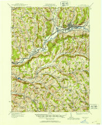
 1909 Delhi1963 Print · USGSDelaware County at the turn of the century is a landscape of valley railroads and high ridgeline farms. Genealogists and researchers can trace family lands near Elk Creek Church, follow the old Ulster and Delaware RR line, or locate early sites in Delhi and Meridale.
 - 1911 Map of Delhi
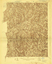
 1911 Delhi1911 Print · USGSDelaware County during the first decade of the twentieth century shows a landscape of rail-driven river towns and high hill farms. You can trace the historic routes of the Ulster and Delaware RR and locate local landmarks like the Elk Creek Church and Wakaqua Falls.5 unique versions available
 - 1915 Map of Oneonta
 1915 Oneonta1915 Print · USGSOtsego and Delaware counties thrived at this moment in the early twentieth century as a busy corridor for the Ulster and Delaware railroad. Genealogists and local historians can trace family-named schoolhouses and the agricultural economy at Arctic Creamery or the rural Franklin Depot.
 - 1915 Map of Unadilla, 1961 Print
 1915 Unadilla1961 Print · USGSThe river valleys of Chenango and Delaware counties are shown here during the height of the steam rail era. Researchers can trace the New York Ontario and Western lines through Sidney and Bainbridge, or locate the Friends Meeting House and dozens of rural schoolhouses.
 - 1918 Map of Unadilla
 1918 Unadilla1918 Print · USGSThe Susquehanna and Unadilla river valleys come alive during the years of World War I, showing a landscape of bustling rail junctions and riverside villages. Genealogists can trace family names at Lathams Corners or locate the Friends Meeting House and Sodom School.6 unique versions available
 - 1918 Map of Oneonta
 1918 Oneonta1918 Print · USGSOneonta and the Susquehanna valley are captured here at a peak of rail-driven commerce during the early twentieth century. Genealogists and historians can locate scores of numbered country schools and rural landmarks like the Arctic Creamery, Wells Bridge, and Franklin Depot.3 unique versions available
 - 1920 Map of Long Eddy
 1920 Long Eddy1920 Print · USGSThe Delaware River borderlands come alive in the 1920s as a hub of rail activity and riverfront commerce. Genealogists can locate family names near landmarks like Peckville P O, Equinunk, and rural schoolhouses like the South Branch School.3 unique versions available
 - 1921 Map of Long Eddy
 1921 Long Eddy1921 Print · USGSThe Delaware River borderlands are captured here in the early twenties, showing a network of small upland communities and river crossings. Genealogists can trace family footprints through numerous rural schoolhouses and landmarks like Read Cemetery, Abrahamsville, and the Ferry.
 - 1921 Map of Livingston Manor, 1952 Print
 1921 Livingston Manor1952 Print · USGSSullivan County in the early twenties is captured here as a landscape of timber processing and rail-connected mountain towns. Genealogists and historians can trace numerous rural districts like the Ireland School or find specific industrial sites such as the Acid Plant and Dye Works.2 unique versions available
 - 1922 Map of Andes, 1955 Print
 1922 Andes1955 Print · USGSThe East Branch Delaware River valley is captured in the 1920s before the creation of the Pepacton Reservoir. Researchers can trace the original locations of Pepacton, Shavertown, and Union Grove, alongside numerous rural schoolhouses like Basin Clove School and Arbuckle School.2 unique versions available
 - 1923 Map of Long Eddy
 1923 Long Eddy1923 Print · USGSThe Delaware River valley thrived in the 1920s as a rail and timber hub between New York and Pennsylvania. Genealogists can trace family roots through the many rural schoolhouses and riverside settlements like Lordville, Equinunk, and Fishs Eddy.5 unique versions available
 - 1923 Map of Walton
 1923 Walton1923 Print · USGSDelaware County in the early 1920s is defined by the winding Delaware River and the busy New York Ontario and Western RR. Genealogists can locate dozens of rural school sites, from the Texas School to Carcass Brook School, alongside hamlets like Beerston and Rock Rift.3 unique versions available
 - 1923 Map of Livingston Manor
 1923 Livingston Manor1923 Print · USGSSullivan County in the early twenties shows a landscape transitioning between timber industries and mountain recreation. Genealogists and historians can locate dozens of district schools like Sprague School and trace industrial sites like the Acid Plant along the Ontario and Western RR.5 unique versions available
 - 1924 Map of Starrucca
 1924 Starrucca1924 Print · USGSThe river-and-rail economy of the Delaware valley is captured here in the mid-1920s during a period of industrial activity. Researchers can trace the junctions of the Erie RR and locate local landmarks like Cadosia Factories and Stockport Sta.
 - 1924 Map of Andes
 1924 Andes1924 Print · USGSDelaware County during the mid-twenties shows a landscape of mountain hollows and river valley life. Genealogists can locate family-named landmarks and local schoolhouses like Miller Hollow School, the settlement of Shavertown, and Cabin Hill Church.4 unique versions available
Showing maps 1-25 of 331
Top cities of Delaware County
- Sidney historical maps
- Walton historical maps
- Delhi historical maps
- Middletown historical maps
- Davenport historical maps
- Hancock historical maps
See more
Frequently asked questions
- What are the different types of historical maps available for Delaware County?
- What is the oldest map of Delaware County?
- Where can I purchase historical maps of Delaware County for my home or office?
- Where can I download high-res historical maps of Delaware County?
- Are there historical topographic maps available for Delaware County?
- Is there historical aerial imagery available for Delaware County?
- Where are historical maps of Delaware County sourced from?