1960s Maps of Stilesville, Deposit
Explore 2 historic maps of Stilesville from the 1960s. These maps offer a rare glimpse into what life looked like during the 1960s — showing old roads, neighborhoods, homes, and landmarks that have changed or disappeared over time.
Whether you're researching your family's past, planning a metal detecting trip, or studying how Stilesville's landscape evolved across the 1960s, these high-resolution maps are a powerful tool for exploring the history of this region.
- Focus on a specific era: All maps on this page are from the 1960s, giving you a focused view of this time period.
- See what’s changed: Compare century-old streets, trails, and buildings to today's modern landscape using overlays and satellite layers.
- Research with precision: Use these maps for genealogy, historical research, land use analysis, or educational projects.
- View, download, or print: Maps are fully viewable online in high resolution, and can be downloaded or printed for your own records.
Start exploring Stilesville's history through authentic maps from the 1960s. This is your window into the past.
Stilesville, Deposit maps
(2)- 1963 Map of Binghamton
 1963 Binghamton1963 Print · USGSThe Southern Tier and Catskill peaks are shown in the early sixties as new reservoirs reshaped the valleys. Trace historic rail corridors like the Erie Lackawanna RR and explore lakeside settlements such as Cooperstown and Oneonta.
 - 1965 Map of Deposit, 1967 Print
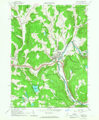 1965 Deposit1967 Print · USGSThe village of Deposit and its surrounding river valleys are captured here in the mid-sixties, shortly after the completion of the Cannonsville Dam. Genealogists and historians can trace the Erie Lackawanna Railroad and find local landmarks like Pine Grove Cem and Oquaga Lake.2 unique versions available
End of results
Showing maps 1-2 of 2
Top cities near Stilesville
- Windsor historical maps
- Sidney historical maps
- Walton historical maps
- Colesville historical maps
- Sidney historical maps
- Bainbridge historical maps
See more
Frequently asked questions
- What are the different types of historical maps available for Stilesville?
- What is the oldest map of Stilesville?
- Where can I purchase historical maps of Stilesville for my home or office?
- Where can I download high-res historical maps of Stilesville?
- Are there historical topographic maps available for Stilesville?
- Is there historical aerial imagery available for Stilesville?
- Where are historical maps of Stilesville sourced from?