1940s Maps of Harpersfield, New York
Explore 11 historic maps of Harpersfield from the 1940s. These maps offer a rare glimpse into what life looked like during the 1940s — showing old roads, neighborhoods, homes, and landmarks that have changed or disappeared over time.
Whether you're researching your family's past, planning a metal detecting trip, or studying how Harpersfield's landscape evolved across the 1940s, these high-resolution maps are a powerful tool for exploring the history of this region.
- Focus on a specific era: All maps on this page are from the 1940s, giving you a focused view of this time period.
- See what’s changed: Compare century-old streets, trails, and buildings to today's modern landscape using overlays and satellite layers.
- Research with precision: Use these maps for genealogy, historical research, land use analysis, or educational projects.
- View, download, or print: Maps are fully viewable online in high resolution, and can be downloaded or printed for your own records.
Start exploring Harpersfield's history through authentic maps from the 1940s. This is your window into the past.
Harpersfield, NY maps
(11)- 1943 Map of Charlotteville, 1960 Print
 1943 Charlotteville1960 Print · USGSOtsego and Schoharie counties appear here in the 1940s, showing a landscape of upland ridges and valley hamlets linked by the Delaware and Hudson rail line. Genealogists can trace family locations near Post Cem, Lutheranville, and several rural schoolhouses like Hollenbeck Sch.4 unique versions available
 - 1943 Map of Schenevus, 1960 Print
 1943 Schenevus1960 Print · USGSThe valleys of Otsego County were defined by rail and water during the 1940s. Genealogists and historians can trace the rural landscape through several numbered schoolhouses, the Delaware and Hudson line, and family sites like Maple Grove Cem.4 unique versions available
 - 1943 Map of Davenport, 1960 Print
 1943 Davenport1960 Print · USGSDelaware County during the 1940s is defined by its rural valley settlements and the essential New York Central rail corridor. Genealogists can trace family roots through upland landmarks like Kortright Center, Fergusonville, and the Covenanter Cem.3 unique versions available
 - 1945 Map of Charlotteville
 1945 Charlotteville1945 Print · USGSThe hill country of Otsego and Schoharie counties comes into focus during the mid-forties, showing a landscape of upland farms and valley railroads. Genealogists can locate family landmarks like Snooks Cem, Dugway Cem, and old district sites such as Mud Lake Sch.
 - 1945 Map of Schenevus
 1945 Schenevus1945 Print · USGSOtsego County villages thrived along the valley rail lines during the mid-forties. Genealogists and local historians can trace rural school districts like School No 16, family burial sites such as Bliven Cem, and the Hooker 2 Lookout Tower overlook.
 - 1945 Map of Davenport
 1945 Davenport1945 Print · USGSMid-century Delaware County is captured here in the hills of Davenport and Kortright just as the dairy economy and rail lines defined rural life. Genealogists can trace family footprints at Kortright Station, Hoseaville, or the old Covenanter Cem.
 - 1945 Map of Stamford, 1960 Print
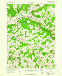
 1945 Stamford1960 Print · USGSUpper Delaware valley life is captured here in the mid-1940s, as mountain agriculture and the railroad defined the border of Schoharie and Delaware counties. Researchers can trace the NEW YORK CENTRAL line to South Gilboa Station or locate family plots at Evergreen Cem and Blenheim Hill Cem.4 unique versions available
 - 1945 Map of Harpersfield, 1960 Print
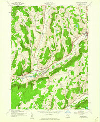
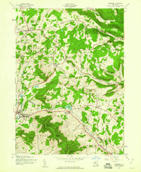
 1945 Harpersfield1960 Print · USGSDelaware County’s upland farms and crossroads hamlets are documented in the 1940s during a period of rural stability. Researchers can trace the New York Central rail line into Stamford and locate old landmarks like School No 6 and Stevens Cem.2 unique versions available
 - 1946 Map of Stamford
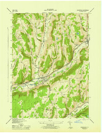
 1946 Stamford1946 Print · USGSSchoharie and Delaware counties are shown at the end of the war, where mountain farming and rail transport define the Catskill foothills. Locate old family landmarks like Choate Cem, the South Gilboa Sta, and the high lookout on Utsayantha Mtn.
 - 1946 Map of Harpersfield
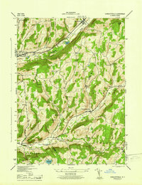
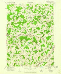
 1946 Harpersfield1946 Print · USGSDelaware County during the mid-forties remains a landscape of high hills and quiet hamlets connected by the storied Catskill Turnpike. Genealogists and researchers can trace family-named points like Stevens Cem, Odell Lake, and rural School No 5.
 - 1948 Map of Binghamton, 1980 Print
 1948 Binghamton1980 Print · USGSCentral New York and the Southern Tier thrive in the late 1940s as a hub of rail traffic and mountain industry. Researchers can trace historic transit lines like the Erie Railroad through Binghamton or find old valley settlements near Oneonta and Delhi.
End of results
Showing maps 1-11 of 11
Top cities near Harpersfield
- Cobleskill historical maps
- Delhi historical maps
- Cobleskill historical maps
- Otsego historical maps
- Middletown historical maps
- Davenport historical maps
See more
Top neighborhoods of Harpersfield
Frequently asked questions
- What are the different types of historical maps available for Harpersfield?
- What is the oldest map of Harpersfield?
- Where can I purchase historical maps of Harpersfield for my home or office?
- Where can I download high-res historical maps of Harpersfield?
- Are there historical topographic maps available for Harpersfield?
- Is there historical aerial imagery available for Harpersfield?
- Where are historical maps of Harpersfield sourced from?