1920s Maps of Walton, New York
Explore 4 historic maps of Walton from the 1920s. These maps offer a rare glimpse into what life looked like during the 1920s — showing old roads, neighborhoods, homes, and landmarks that have changed or disappeared over time.
Whether you're researching your family's past, planning a metal detecting trip, or studying how Walton's landscape evolved across the 1920s, these high-resolution maps are a powerful tool for exploring the history of this region.
- Focus on a specific era: All maps on this page are from the 1920s, giving you a focused view of this time period.
- See what’s changed: Compare century-old streets, trails, and buildings to today's modern landscape using overlays and satellite layers.
- Research with precision: Use these maps for genealogy, historical research, land use analysis, or educational projects.
- View, download, or print: Maps are fully viewable online in high resolution, and can be downloaded or printed for your own records.
Start exploring Walton's history through authentic maps from the 1920s. This is your window into the past.
Walton, NY maps
(4)- 1922 Map of Andes, 1955 Print
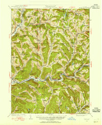 1922 Andes1955 Print · USGSThe East Branch Delaware River valley is captured in the 1920s before the creation of the Pepacton Reservoir. Researchers can trace the original locations of Pepacton, Shavertown, and Union Grove, alongside numerous rural schoolhouses like Basin Clove School and Arbuckle School.2 unique versions available
 - 1923 Map of Walton
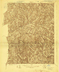 1923 Walton1923 Print · USGSDelaware County in the early 1920s is defined by the winding Delaware River and the busy New York Ontario and Western RR. Genealogists can locate dozens of rural school sites, from the Texas School to Carcass Brook School, alongside hamlets like Beerston and Rock Rift.3 unique versions available
 - 1924 Map of Andes
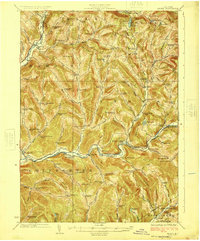 1924 Andes1924 Print · USGSDelaware County during the mid-twenties shows a landscape of mountain hollows and river valley life. Genealogists can locate family-named landmarks and local schoolhouses like Miller Hollow School, the settlement of Shavertown, and Cabin Hill Church.4 unique versions available
 - 1925 Map of Walton
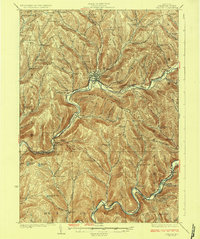 1925 Walton1925 Print · USGSDelaware County during the mid-1920s is a landscape of rugged river valleys and remote hill-country farming communities. Genealogists can trace family roots through numerous local landmarks like Knickerbocker School, the village of Shinhopple, and the rail stops of the New York Ontario and Western RR.5 unique versions available
End of results
Showing maps 1-4 of 4
Top cities near Walton
- Sidney historical maps
- Delhi historical maps
- Unadilla historical maps
- Rockland historical maps
- Walton historical maps
- Hancock historical maps
See more
Top neighborhoods of Walton
- Loomis historical maps
- Northfield historical maps
- Pinesville historical maps
- Beerston historical maps
- Walton historical maps
- Colchester historical maps
Frequently asked questions
- What are the different types of historical maps available for Walton?
- What is the oldest map of Walton?
- Where can I purchase historical maps of Walton for my home or office?
- Where can I download high-res historical maps of Walton?
- Are there historical topographic maps available for Walton?
- Is there historical aerial imagery available for Walton?
- Where are historical maps of Walton sourced from?