1960s Maps of Walton, New York
Explore 6 historic maps of Walton from the 1960s. These maps offer a rare glimpse into what life looked like during the 1960s — showing old roads, neighborhoods, homes, and landmarks that have changed or disappeared over time.
Whether you're researching your family's past, planning a metal detecting trip, or studying how Walton's landscape evolved across the 1960s, these high-resolution maps are a powerful tool for exploring the history of this region.
- Focus on a specific era: All maps on this page are from the 1960s, giving you a focused view of this time period.
- See what’s changed: Compare century-old streets, trails, and buildings to today's modern landscape using overlays and satellite layers.
- Research with precision: Use these maps for genealogy, historical research, land use analysis, or educational projects.
- View, download, or print: Maps are fully viewable online in high resolution, and can be downloaded or printed for your own records.
Start exploring Walton's history through authentic maps from the 1960s. This is your window into the past.
Walton, NY maps
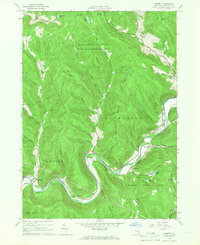
(6)- 1963 Map of Binghamton
 1963 Binghamton1963 Print · USGSThe Southern Tier and Catskill peaks are shown in the early sixties as new reservoirs reshaped the valleys. Trace historic rail corridors like the Erie Lackawanna RR and explore lakeside settlements such as Cooperstown and Oneonta.
 - 1965 Map of Corbett, 1966 Print
 1965 Corbett1966 Print · USGSThe East Branch of the Delaware River winds through the Catskills in the mid-1960s, connecting small valley settlements. Researchers can trace family sites at the Gregorytown Cem or explore landmarks like the Downsville Airport and Quinn Lake.3 unique versions available
 - 1965 Map of Readburn, 1966 Print
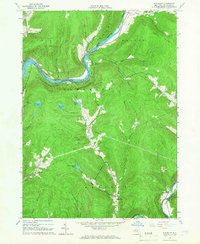 1965 Readburn1966 Print · USGSDelaware County's river valleys and forest preserves are shown here in the mid-sixties during a period of significant hydrological change. Researchers can trace rural life at Readburn and Beerston, or locate family sites like the Readburn Cem and Community Full Gospel Ch.3 unique versions available
 - 1965 Map of Walton West, 1966 Print
 1965 Walton West1966 Print · USGSDelaware County at the height of the 1960s reveals a landscape of river-valley villages and steep Catskill ridges. Local researchers can trace family landmarks and civic sites like the Walton Cem, Dryden Community Ch, and the village Fairgrounds.2 unique versions available
 - 1965 Map of Walton East, 1966 Print
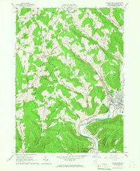
 1965 Walton East1966 Print · USGSDelaware County in the mid-1960s is defined here by the river-cut valleys of the Catskill foothills and the village of Walton. Genealogists and historians can trace family-named landmarks like Mac Gibbon Hollow and the path of the Old Railroad Grade.2 unique versions available
 - 1965 Map of Hamden, 1967 Print
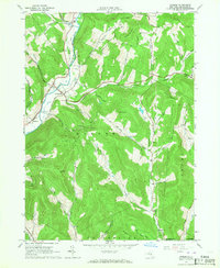 1965 Hamden1967 Print · USGSMid-century Delaware County life centers on the river valley between Hamden and De Lancey in this mid-1960s survey. Researchers can trace family-named landmarks through the steep terrain, from Arbuckle Hollow to the ridges of the Devils Backbone.2 unique versions available
End of results
Showing maps 1-6 of 6
Top cities near Walton
- Sidney historical maps
- Delhi historical maps
- Unadilla historical maps
- Rockland historical maps
- Walton historical maps
- Hancock historical maps
See more
Top neighborhoods of Walton
- Loomis historical maps
- Northfield historical maps
- Pinesville historical maps
- Beerston historical maps
- Walton historical maps
- Colchester historical maps
Frequently asked questions
- What are the different types of historical maps available for Walton?
- What is the oldest map of Walton?
- Where can I purchase historical maps of Walton for my home or office?
- Where can I download high-res historical maps of Walton?
- Are there historical topographic maps available for Walton?
- Is there historical aerial imagery available for Walton?
- Where are historical maps of Walton sourced from?