1940s Maps of Dover, New York
Explore 8 historic maps of Dover from the 1940s. These maps offer a rare glimpse into what life looked like during the 1940s — showing old roads, neighborhoods, homes, and landmarks that have changed or disappeared over time.
Whether you're researching your family's past, planning a metal detecting trip, or studying how Dover's landscape evolved across the 1940s, these high-resolution maps are a powerful tool for exploring the history of this region.
- Focus on a specific era: All maps on this page are from the 1940s, giving you a focused view of this time period.
- See what’s changed: Compare century-old streets, trails, and buildings to today's modern landscape using overlays and satellite layers.
- Research with precision: Use these maps for genealogy, historical research, land use analysis, or educational projects.
- View, download, or print: Maps are fully viewable online in high resolution, and can be downloaded or printed for your own records.
Start exploring Dover's history through authentic maps from the 1940s. This is your window into the past.
Dover, NY maps
(8)- 1944 Map of Dover Plains, 1956 Print
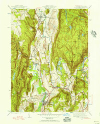 1944 Dover Plains1956 Print · USGSDutchess County at the close of the Second World War was a landscape of fertile valleys and mountain ridges. Genealogists and historians can trace rail-side life and local landmarks like Dover Plains, the Appalachian Trail, and the Schaghticoke Indian Reservation.2 unique versions available
 - 1945 Map of Pawling, 1956 Print
 1945 Pawling1956 Print · USGSDutchess County at the close of the Second World War reveals a landscape of high ridges and significant wetlands along the New York-Connecticut border. Genealogists and local historians can trace legacy landmarks including the Quaker Hill Meeting House, the village of Pawling, and the vast expanse of The Great Swamp.2 unique versions available
 - 1946 Map of Verbank
 1946 Verbank1946 Print · USGSDutchess County is captured here in the mid-1940s, showing a landscape of interior ridges and tight-knit valley settlements. Genealogists and local historians can trace the footprint of the Greer School at Hope Farm, the Oswego Ch, and small rural schoolhouses like Sunnyside Sch.3 unique versions available
 - 1947 Map of Pawling
 1947 Pawling1947 Print · USGSDutchess County at the edge of Connecticut was a landscape of highland ridges and river valleys in the late 1940s. Genealogists can locate family landmarks such as Hurd Sch, Akins Corners, and the historic Quaker Hill Meeting House.2 unique versions available
 - 1947 Map of Dover Plains
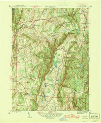
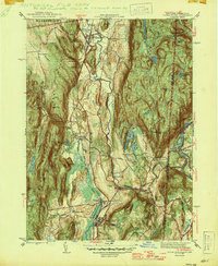 1947 Dover Plains1947 Print · USGSDutchess County at the edge of the Connecticut border reveals a landscape of state institutions, mountain ridges, and river valleys in the late 1940s. Genealogists can trace family landmarks like Valley View Cem or search for old schoolhouses including Dover Furnace Sch and Webatuck Sch.2 unique versions available
 - 1947 Map of Hartford, 1955 Print
 1947 Hartford1955 Print · USGSSouthern New England and the Hudson Valley are shown in detail during the post-war expansion era. Genealogists and researchers can trace local landmarks from the State Capitol and Yale University to the Stratford Lighthouse and Woodlawn Cem.2 unique versions available
 - 1948 Map of Poughquag
 1948 Poughquag1948 Print · USGSDutchess and Putnam counties are captured here in the late 1940s, showing the early path of the Appalachian Trail through the New York highlands. Researchers can trace the massive Disciplinary Barracks at Green Haven and old schoolhouses like Gardner Hollow Sch.2 unique versions available
 - 1948 Map of Hartford
 1948 Hartford1948 Print · USGSSouthern New England is captured here in the late 1940s, showcasing a landscape of thriving industrial cities and developing parkways. Genealogists and historians can trace the rail networks of the New York New Haven and Hartford RR or locate coastal defense sites like Fort Terry and Camp Shanks.2 unique versions available
End of results
Showing maps 1-8 of 8
Top cities near Dover
- Danbury historical maps
- East Fishkill historical maps
- Brookfield historical maps
- La Grange historical maps
- New Fairfield historical maps
- Beekman historical maps
See more
Top neighborhoods of Dover
- Dogtail Corners historical maps
- Oniontown historical maps
- South Dover historical maps
- Webatuck historical maps
- Dover Furnace historical maps
- Chestnut Ridge historical maps
See more
Frequently asked questions
- What are the different types of historical maps available for Dover?
- What is the oldest map of Dover?
- Where can I purchase historical maps of Dover for my home or office?
- Where can I download high-res historical maps of Dover?
- Are there historical topographic maps available for Dover?
- Is there historical aerial imagery available for Dover?
- Where are historical maps of Dover sourced from?