1950s Maps of Dover, New York
Explore 3 historic maps of Dover from the 1950s. These maps offer a rare glimpse into what life looked like during the 1950s — showing old roads, neighborhoods, homes, and landmarks that have changed or disappeared over time.
Whether you're researching your family's past, planning a metal detecting trip, or studying how Dover's landscape evolved across the 1950s, these high-resolution maps are a powerful tool for exploring the history of this region.
- Focus on a specific era: All maps on this page are from the 1950s, giving you a focused view of this time period.
- See what’s changed: Compare century-old streets, trails, and buildings to today's modern landscape using overlays and satellite layers.
- Research with precision: Use these maps for genealogy, historical research, land use analysis, or educational projects.
- View, download, or print: Maps are fully viewable online in high resolution, and can be downloaded or printed for your own records.
Start exploring Dover's history through authentic maps from the 1950s. This is your window into the past.
Dover, NY maps
(3)- 1958 Map of Amenia, 1959 Print
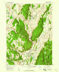 1958 Amenia1959 Print · USGSDutchess County in the late fifties shows a rural landscape anchored by the New York Central Railroad and several historic hamlets. Researchers can trace the layout of the Wassaic State School or locate family sites near the Stone Church and Millbrook Cem.5 unique versions available
 - 1958 Map of Pawling, 1960 Print
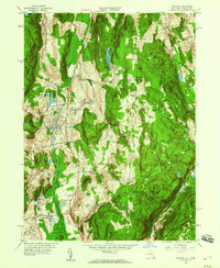 1958 Pawling1960 Print · USGSDutchess County and eastern Connecticut are mapped here in the late fifties, showing the region as the Harlem Valley railroad corridor remained central to local life. Genealogists can trace family landmarks and schools like Trinity-Pawling Sch, the Meeting House on Quaker Hill, and old junctions at Hurd Corners.4 unique versions available
 - 1958 Map of Dover Plains, 1960 Print
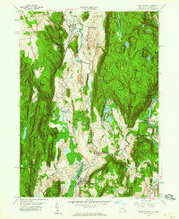 1958 Dover Plains1960 Print · USGSDutchess County enters the late fifties with its rail-and-river corridor well-established between Dover Plains and Wingdale. Genealogists and hikers can trace the Appalachian Trail past the Schaghticoke Indian Reservation and locate landmarks like Dover Furnace and the Valley View Cem.4 unique versions available
End of results
Showing maps 1-3 of 3
Top cities near Dover
- Danbury historical maps
- East Fishkill historical maps
- Brookfield historical maps
- La Grange historical maps
- New Fairfield historical maps
- Beekman historical maps
See more
Top neighborhoods of Dover
- Dogtail Corners historical maps
- Oniontown historical maps
- South Dover historical maps
- Webatuck historical maps
- Dover Furnace historical maps
- Chestnut Ridge historical maps
See more
Frequently asked questions
- What are the different types of historical maps available for Dover?
- What is the oldest map of Dover?
- Where can I purchase historical maps of Dover for my home or office?
- Where can I download high-res historical maps of Dover?
- Are there historical topographic maps available for Dover?
- Is there historical aerial imagery available for Dover?
- Where are historical maps of Dover sourced from?