1940s Maps of Boston, New York
Explore 4 historic maps of Boston from the 1940s. These maps offer a rare glimpse into what life looked like during the 1940s — showing old roads, neighborhoods, homes, and landmarks that have changed or disappeared over time.
Whether you're researching your family's past, planning a metal detecting trip, or studying how Boston's landscape evolved across the 1940s, these high-resolution maps are a powerful tool for exploring the history of this region.
- Focus on a specific era: All maps on this page are from the 1940s, giving you a focused view of this time period.
- See what’s changed: Compare century-old streets, trails, and buildings to today's modern landscape using overlays and satellite layers.
- Research with precision: Use these maps for genealogy, historical research, land use analysis, or educational projects.
- View, download, or print: Maps are fully viewable online in high resolution, and can be downloaded or printed for your own records.
Start exploring Boston's history through authentic maps from the 1940s. This is your window into the past.
Boston, NY maps
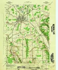
(4)- 1944 Map of Eden
 1944 Eden1944 Print · USGSCoastal Lake Erie and the inland valleys of Erie County are seen here during the mid-1940s. Genealogists can trace family footprints through the Cattaraugus Indian Reservation or old rail stops like Idlewood Sta and Lawton Sta.
 - 1944 Map of Hamburg
 1944 Hamburg1944 Print · USGSHamburg and its surrounding valleys are captured here during the mid-1940s as the regional landscape balanced industry and recreation. Genealogists can trace family footprints near Eden Valley or explore the early layout of the Erie County Fairgrounds and Chestnut Ridge Park.
 - 1944 Map of Langford
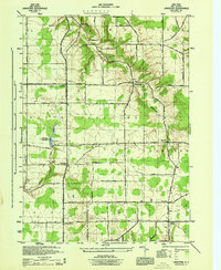 1944 Langford1944 Print · USGSSouthern Erie County is captured here in the mid-1940s, showing a landscape of established farmsteads and rural crossroads communities. Researchers can trace family names and small settlements such as New Oregon, Clarksburg, and the state hospital reservoir near Marshfield.
 - 1948 Map of Hamburg
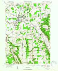 1948 Hamburg1948 Print · USGSSouthern Erie County was a mix of bustling rail hubs and rural dairy country just after the war. You can trace the path of the Erie RR through Hamburg, or locate family landmarks like the Erie County Fairgrounds and Chestnut Ridge Park.
End of results
Showing maps 1-4 of 4
Top cities near Boston
- Buffalo historical maps
- Cheektowaga historical maps
- Hamburg historical maps
- West Seneca historical maps
- Lancaster historical maps
- Orchard Park historical maps
See more
Top neighborhoods of Boston
Frequently asked questions
- What are the different types of historical maps available for Boston?
- What is the oldest map of Boston?
- Where can I purchase historical maps of Boston for my home or office?
- Where can I download high-res historical maps of Boston?
- Are there historical topographic maps available for Boston?
- Is there historical aerial imagery available for Boston?
- Where are historical maps of Boston sourced from?