1960s Maps of Collins, New York
Explore 8 historic maps of Collins from the 1960s. These maps offer a rare glimpse into what life looked like during the 1960s — showing old roads, neighborhoods, homes, and landmarks that have changed or disappeared over time.
Whether you're researching your family's past, planning a metal detecting trip, or studying how Collins's landscape evolved across the 1960s, these high-resolution maps are a powerful tool for exploring the history of this region.
- Focus on a specific era: All maps on this page are from the 1960s, giving you a focused view of this time period.
- See what’s changed: Compare century-old streets, trails, and buildings to today's modern landscape using overlays and satellite layers.
- Research with precision: Use these maps for genealogy, historical research, land use analysis, or educational projects.
- View, download, or print: Maps are fully viewable online in high resolution, and can be downloaded or printed for your own records.
Start exploring Collins's history through authentic maps from the 1960s. This is your window into the past.
Collins, NY maps
(8)- 1960 Map of Buffalo
 1960 Buffalo1960 Print · USGSWestern New York and the Niagara Peninsula thrive during the mid-twentieth century industrial peak. Genealogists and historians can trace family-named points and early settlements from Dunkirk Light to the Allegany Indian Reservation.
 - 1960 Map of Langford, 1962 Print
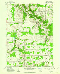 1960 Langford1962 Print · USGSSouthern Erie County is captured here in the early sixties, showing a landscape defined by natural gas extraction and rural crossroads. Genealogists and historians can trace family-named sites such as Dittman Cem or visit old communities like Langford, New Oregon, and Whites Corners.2 unique versions available
 - 1960 Map of North Collins, 1962 Print
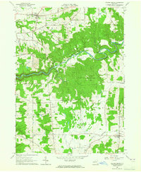
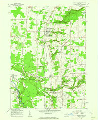 1960 North Collins1962 Print · USGSWestern New York at the start of the sixties shows a landscape of deep creek gulfs, active rail lines, and Seneca territory. Genealogists can locate the Friends Meetinghouse Burial Grounds, Cattaraugus Long House Ch, and the Gowanda State Hospital Annex.2 unique versions available
 - 1960 Map of Farnham, 1963 Print
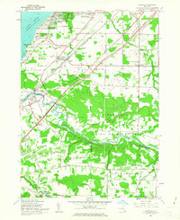 1960 Farnham1963 Print · USGSCoastal Erie County and the northern reaches of Chautauqua County are captured here in the early sixties, showing the intersection of new expressways and established lakeside communities. Researchers can trace family history through sites like St Anthonys Ch and the Rathburn Cem or explore the boundaries of the Cattaraugus Indian Reservation.2 unique versions available
 - 1962 Map of Buffalo, 1980 Print
 1962 Buffalo1980 Print · USGSThe Niagara Frontier and Western New York are captured here in the early sixties, showing the vital industrial and maritime nexus between the U.S. and Canada. Researchers can trace the path of the Welland Canal, locate the Allegany Indian Reservation, or find family sites near Chautauqua Lake.2 unique versions available
 - 1963 Map of Gowanda, 1964 Print
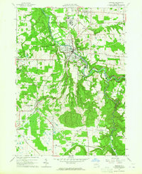 1963 Gowanda1964 Print · USGSThe Erie and Cattaraugus county line comes alive in the early 1960s, showing the bustling village of Gowanda and the Erie-Lackawanna rail corridor. Trace family roots at Pine Grove Cem, the Pine Woods Ch, and the Gowanda State Hospital grounds.2 unique versions available
 - 1963 Map of Collins Center, 1965 Print
 1963 Collins Center1965 Print · USGSThe rural borderlands of Erie and Cattaraugus Counties are documented here in the early sixties. Researchers can trace family sites near Knight Cem, navigate the roads to Zoar, or locate old energy infrastructure like the scattered Gas Wells.3 unique versions available
 - 1967 Map of Buffalo
 1967 Buffalo1967 Print · USGSWestern New York and the Lake Erie shoreline are shown here during the mid-1960s industrial peak. Researchers can trace the massive rail networks of the Erie Railroad, locate the Cattaraugus Indian Reservation, or find historic sites like Fort Erie.
End of results
Showing maps 1-8 of 8
Top cities near Collins
- Hamburg historical maps
- Orchard Park historical maps
- Evans historical maps
- Hamburg historical maps
- Concord historical maps
- Boston historical maps
See more
Top neighborhoods of Collins
- Sulphur Springs historical maps
- Bagdad historical maps
- Four Mile Level historical maps
- Pinewoods historical maps
- Taylor Hollow historical maps
- Zoar historical maps
See more
Frequently asked questions
- What are the different types of historical maps available for Collins?
- What is the oldest map of Collins?
- Where can I purchase historical maps of Collins for my home or office?
- Where can I download high-res historical maps of Collins?
- Are there historical topographic maps available for Collins?
- Is there historical aerial imagery available for Collins?
- Where are historical maps of Collins sourced from?