1950s Maps of Harrietstown, New York
Explore 6 historic maps of Harrietstown from the 1950s. These maps offer a rare glimpse into what life looked like during the 1950s — showing old roads, neighborhoods, homes, and landmarks that have changed or disappeared over time.
Whether you're researching your family's past, planning a metal detecting trip, or studying how Harrietstown's landscape evolved across the 1950s, these high-resolution maps are a powerful tool for exploring the history of this region.
- Focus on a specific era: All maps on this page are from the 1950s, giving you a focused view of this time period.
- See what’s changed: Compare century-old streets, trails, and buildings to today's modern landscape using overlays and satellite layers.
- Research with precision: Use these maps for genealogy, historical research, land use analysis, or educational projects.
- View, download, or print: Maps are fully viewable online in high resolution, and can be downloaded or printed for your own records.
Start exploring Harrietstown's history through authentic maps from the 1950s. This is your window into the past.
Harrietstown, NY maps
(6)- 1951 Map of Ogdensburg
 1951 Ogdensburg1951 Print · USGSThe St. Lawrence frontier and the North Country are captured here during the post-war era, from the river ports to the high Adirondacks. Genealogists and historians can trace the rail-and-river economy through Ogdensburg, the Rutland rail lines, and Potsdam.
 - 1953 Map of Ogdensburg
 1953 Ogdensburg1953 Print · USGSThe North Country and St. Lawrence Valley are shown here in the early fifties, just as the region’s rail-and-river economy remained in full swing. Genealogists and historians can trace family-named corners and rural hubs along the Rutland railroad or locate heritage sites near Ogdensburg, Potsdam, and the St Regis Indian Reservation.
 - 1953 Map of Santanoni, 1957 Print
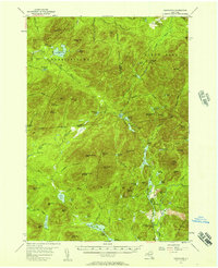 1953 Santanoni1957 Print · USGSThe High Peaks of Essex County are documented in the early 1950s, showing a landscape defined by deep wilderness and early industrial outposts. Researchers can trace the Northville Placid Trail or locate the Old MacIntyre Furnace and the settlement at Tahawus.5 unique versions available
 - 1955 Map of Long Lake, 1957 Print
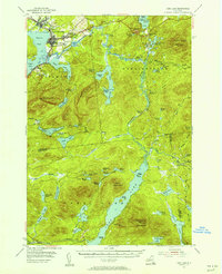 1955 Long Lake1957 Print · USGSThe Adirondack lake country comes alive in the mid-1950s, showing the intersection of village life and deep wilderness. Trace local history through landmarks like the Veterans Hospital, the settlement at Coreys, and the St Alphonsus Ch.6 unique versions available
 - 1955 Map of Saranac Lake, 1957 Print
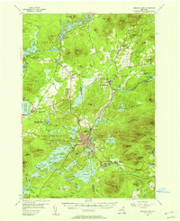 1955 Saranac Lake1957 Print · USGSSaranac Lake and its surrounding mountain communities were flourishing hubs of the Adirondacks during the mid-fifties. Researchers can trace family history through sites like St Pauls Cem, rural landmarks like Eight Square Sch, and the rail infrastructure at Lake Clear Junction.5 unique versions available
 - 1955 Map of Saint Regis, 1957 Print
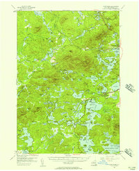 1955 Saint Regis1957 Print · USGSThe Adirondack lake country comes alive in the mid-1950s, showing the intersection of remote wilderness and early tourism. Researchers can trace the sprawling grounds of Paul Smiths College, the route of the New York Central Railroad, and landmarks like Keese Mill.5 unique versions available
End of results
Showing maps 1-6 of 6
Top cities near Harrietstown
- North Elba historical maps
- Tupper Lake historical maps
- Saranac Lake historical maps
- Tupper Lake historical maps
- Saint Armand historical maps
- Brighton historical maps
See more
Top neighborhoods of Harrietstown
- McMasters Crossing historical maps
- Lake Clear historical maps
- Upper Saint Regis historical maps
- Wawbeek historical maps
- Lake Colby historical maps
Frequently asked questions
- What are the different types of historical maps available for Harrietstown?
- What is the oldest map of Harrietstown?
- Where can I purchase historical maps of Harrietstown for my home or office?
- Where can I download high-res historical maps of Harrietstown?
- Are there historical topographic maps available for Harrietstown?
- Is there historical aerial imagery available for Harrietstown?
- Where are historical maps of Harrietstown sourced from?