Old Maps of Franklin County, New York
Explore 335 old maps of Franklin County, spanning from 1896 to today. These high-resolution historic maps reveal how streets, neighborhoods, landmarks, and natural features evolved over time — perfect for genealogy, metal detecting, research, and local history exploration.
What you can do with these maps:
- See how Franklin County changed over time: Compare historical maps to modern-day views to trace roads, homesites, rail lines & more.
- View detailed metadata: Each map includes creators, publishers, year, scale, and archive source.
- Overlay maps with satellite & LiDAR: Visualize the past alongside modern tools to explore terrain & human change.
- Trusted historical sources: Maps sourced from the USGS, Library of Congress, and other archives.
- Access maps your way: View online, download high-res files, or order prints for personal or research use.
Start exploring old maps of Franklin County to uncover forgotten places, hidden landmarks, and the deep history beneath your feet.
Franklin County, NY maps
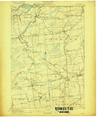
(335)- 1896 Map of Lake Placid
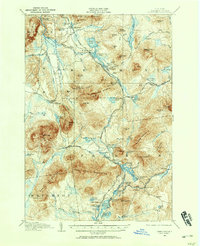
 1896 Lake Placid1896 Print · USGSThe High Peaks wilderness of the 1890s reveals a landscape of early iron industry and burgeoning mountain tourism. Genealogists and hikers can trace the original paths around John Browns Grave, the industry at West Kilns, and the early buildings at Undercliff.
 - 1898 Map of Lake Placid
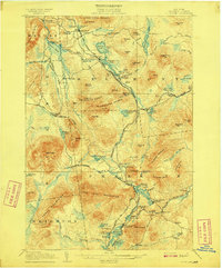
 1898 Lake Placid1898 Print · USGSThe Adirondack High Peaks are captured here in the late nineteenth century as the region evolved into a premier destination for hikers and historians. Trace the early settlement of Lake Placid, the industrial sites at West Kilns, and the landmark John Browns Grave.12 unique versions available
 - 1902 Map of Saranac, 1953 Print
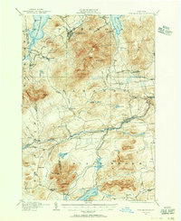
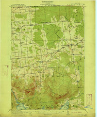
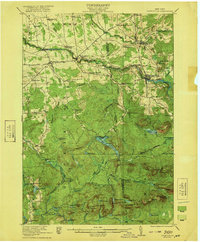
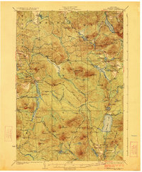
 1902 Saranac1953 Print · USGSThe Adirondack High Peaks region comes alive in this survey from the early 1900s, showcasing the expansion of rail and water-based commerce. Researchers can trace the development of Saranac Lake, locate early industrial sites like Ames Mills, and follow the path of the Adirondack Division railroad.
 - 1904 Map of Saranac
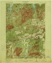
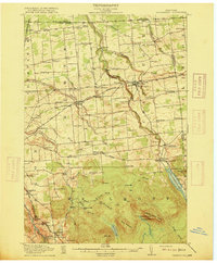
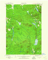
 1904 Saranac1904 Print · USGSSaranac Lake and the northern Adirondacks are captured here during the height of the early railroad era. Genealogists and historians can trace the paths of the Adirondack Division and Chateaugay Branch through settlements like Bloomingdale, Gabriels, and Onchiota.10 unique versions available
 - 1904 Map of Santanoni
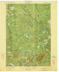
 1904 Santanoni1904 Print · USGSThe Adirondack High Peaks are shown in the early twentieth century, an era of private sporting clubs and heavy iron mining. Trace early trails and remote outposts like Mac Intyre Ironworks, Camp Santanoni, and the Tahawus Club.10 unique versions available
 - 1904 Map of Long Lake
 1904 Long Lake1904 Print · USGSThe Adirondack wilderness of the early 1900s is shown here as a landscape of logging camps and lakeside retreats. Trace the Steamboat Route on Long Lake to Island House, or locate old rail junctions near Faust and Coreys P.O.10 unique versions available
 - 1905 Map of Saint Regis
 1905 Saint Regis1905 Print · USGSFranklin County's wilderness is captured at the height of the early resort and logging era, showing the rail lines that opened these woods to the world. Trace the paths of the Adirondack Division or locate historic outposts like Brandon, Paul Smiths, and Wawbeek.9 unique versions available
 - 1906 Map of Loon Lake, 1958 Print
 1906 Loon Lake1958 Print · USGSThe northern Adirondacks at the turn of the century are shown here as a landscape of remote mountain outposts and expanding rail lines. Researchers can trace early family-named sites like Hunter Home, local industries at Upper Kilns, and the junction of the Delaware and Hudson railroad.2 unique versions available
 - 1907 Map of Tupper Lake
 1907 Tupper Lake1907 Print · USGSThe Adirondack wilderness at the turn of the century shows a landscape defined by new rail lines and remote sporting clubs. Researchers can trace the early rail stops at Piercefield Sta and Childwold Sta or locate the isolated Sabattis P O and Ushers Farm.8 unique versions available
 - 1908 Map of Loon Lake
 1908 Loon Lake1908 Print · USGSFranklin County's mountain wilderness is captured here in the early twentieth century, showing a landscape defined by timber kilns and nascent rail travel. Genealogists and historians can trace old homesteads and landmarks like Inman PO, Bryants Mill, and the historic Port Kent and Hopkinton Turnpike.6 unique versions available
 - 1911 Map of Lyon Mountain, 1956 Print
 1911 Lyon Mountain1956 Print · USGSThe northern Adirondacks at the peak of the iron era reveal a landscape of mining hamlets and mountain kilns. Genealogists can trace family footprints in Loudell PO, Standish, and Sugarbush, or follow the industrial path of the Delaware and Hudson RR.2 unique versions available
 - 1913 Map of Lyon Mountain
 1913 Lyon Mountain1913 Print · USGSThe northern Adirondacks in the pre-war years were a landscape of mountain hamlets and industrial outposts. Genealogists and historians can trace the foundations of Lyon Mountain, locate the Loudell P.O., and follow the Delaware and Hudson RR through the high country.5 unique versions available
 - 1915 Map of Churubusco
 1915 Churubusco1915 Print · USGSNorthern Clinton County is documented here in the early twentieth century, showing a landscape of boundary settlements and mountain lakes. Genealogists can trace family footprints through numerous rural schoolhouses and junctions like Harrigan Corners, Churubusco, and the Halfway House.7 unique versions available
 - 1915 Map of Chateaugay
 1915 Chateaugay1915 Print · USGSNorthern Franklin County appears here during the height of its rail-and-mill era, bordering the international boundary with Canada. Genealogists can trace family footprints through dozens of numbered schoolhouses, the White Church, and industrial sites like Cooks Mill or The Forge.4 unique versions available
 - 1915 Map of Malone, 1957 Print
 1915 Malone1957 Print · USGSFranklin County at the onset of the Great War reveals a landscape defined by industrial rail junctions and a dense network of district schools. Genealogists can trace family roots through numerous rural school sites and landmarks like the County Almshouse, Malone Junction, and Fort Covington.2 unique versions available
 - 1915 Map of Moira, 1957 Print
 1915 Moira1957 Print · USGSNorthern New York's borderlands are captured here in the early twentieth century, showing the intersection of tribal lands and rail-driven commerce. Genealogists can trace family names and early rural life through Brasher Iron Works, Potter School, and Irish Corners.
 - 1917 Map of Malone
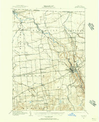
 1917 Malone1917 Print · USGSNorthern New York's borderlands are captured here during the height of the steam-rail era, centered on the busy junction at Malone. Genealogists and local historians can trace family locations near dozens of rural schoolhouses or along the Rutland RR and Salmon River.5 unique versions available
 - 1917 Map of Moira
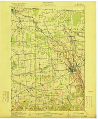
 1917 Moira1917 Print · USGSNorthern New York's borderlands come alive in the years before the Great War, showing a landscape defined by the St Regis Indian Reservation and busy rail lines. Researchers can trace family landmarks like Laverys Corner, the Brasher Iron Works, and early industrial sites like Wagstaff Factory.4 unique versions available
 - 1919 Map of Nicholville, 1958 Print
 1919 Nicholville1958 Print · USGSIn the Adirondack foothills during the early twentieth century, small riverside settlements and timber camps defined local life. Genealogists can trace family footprints through numerous rural schoolhouses like Water Street School and old crossroads like Heath Hill Corners.2 unique versions available
 - 1920 Map of Childwold, 1954 Print
 1920 Childwold1954 Print · USGSIn the Adirondack interior during the early 1920s, this area showcases a network of timber camps and early sporting clubs. Researchers can trace the riverfront development of Hollywood and Childwold, or locate landmarks like the Shur-leff Hotel and Kildare.2 unique versions available
 - 1921 Map of Childwold
 1921 Childwold1921 Print · USGSThe Adirondack wilderness in the early twenties was a landscape of remote sporting clubs and isolated river outposts. Genealogists and historians can trace old homesteads and landmarks like the Shurtleff Hotel, Childwold School, and the long-vanished community of Hollywood.
 - 1921 Map of Nicholville
 1921 Nicholville1921 Print · USGSUpper St. Lawrence and Franklin counties come alive in the early twentieth century as a landscape of timber-driven river towns and rural school districts. Genealogists can trace family footprints near St Regis Falls, Dickinson Center, and numerous rural sites like Harper School or Joe Indian.4 unique versions available
 - 1921 Map of Santa Clara, 1960 Print
 1921 Santa Clara1960 Print · USGSFranklin County's deep woods and timber-driven rail lines are captured here in the early 1920s. Genealogists and historians can locate rural schoolhouses like School No 7 and vanished logging stops along the Brooklyn Cooperage RR or near Santa Clara.2 unique versions available
 - 1922 Map of Childwold
 1922 Childwold1922 Print · USGSThe St. Lawrence County wilderness in the early twenties is a landscape of isolated camps and early Adirondack outposts. Local historians can locate vanished sites like the Shurtleff Hotel or trace the early foundations of Childwold and Hollywood near the Jordan River.4 unique versions available
 - 1923 Map of Santa Clara
 1923 Santa Clara1923 Print · USGSFranklin County's North Country is captured here in the early twenties, showing a landscape of timber-driven rail lines and mountain hamlets. Researchers can trace the New York Central Railroad through Santa Clara or locate the old McCollom School and Everton settlement.5 unique versions available
Showing maps 1-25 of 335
Top cities of Franklin County
- Malone historical maps
- Harrietstown historical maps
- Tupper Lake historical maps
- Moira historical maps
- Bangor historical maps
- Westville historical maps
See more
Frequently asked questions
- What are the different types of historical maps available for Franklin County?
- What is the oldest map of Franklin County?
- Where can I purchase historical maps of Franklin County for my home or office?
- Where can I download high-res historical maps of Franklin County?
- Are there historical topographic maps available for Franklin County?
- Is there historical aerial imagery available for Franklin County?
- Where are historical maps of Franklin County sourced from?