Old Maps of Bellmont, New York
Explore 61 old maps of Bellmont, spanning from 1906 to today. These high-resolution historic maps reveal how streets, neighborhoods, landmarks, and natural features evolved over time — perfect for genealogy, metal detecting, research, and local history exploration.
What you can do with these maps:
- See how Bellmont changed over time: Compare historical maps to modern-day views to trace roads, homesites, rail lines & more.
- View detailed metadata: Each map includes creators, publishers, year, scale, and archive source.
- Overlay maps with satellite & LiDAR: Visualize the past alongside modern tools to explore terrain & human change.
- Trusted historical sources: Maps sourced from the USGS, Library of Congress, and other archives.
- Access maps your way: View online, download high-res files, or order prints for personal or research use.
Start exploring old maps of Bellmont to uncover forgotten places, hidden landmarks, and the deep history beneath your feet.
Bellmont, NY maps
(61)- 1906 Map of Loon Lake, 1958 Print
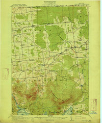
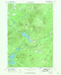
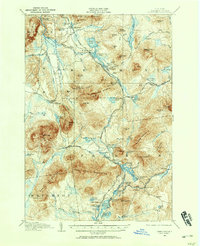 1906 Loon Lake1958 Print · USGSThe northern Adirondacks at the turn of the century are shown here as a landscape of remote mountain outposts and expanding rail lines. Researchers can trace early family-named sites like Hunter Home, local industries at Upper Kilns, and the junction of the Delaware and Hudson railroad.2 unique versions available
 - 1908 Map of Loon Lake
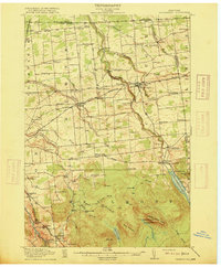
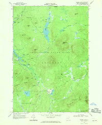
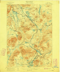 1908 Loon Lake1908 Print · USGSFranklin County's mountain wilderness is captured here in the early twentieth century, showing a landscape defined by timber kilns and nascent rail travel. Genealogists and historians can trace old homesteads and landmarks like Inman PO, Bryants Mill, and the historic Port Kent and Hopkinton Turnpike.6 unique versions available
 - 1911 Map of Lyon Mountain, 1956 Print
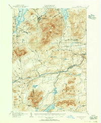 1911 Lyon Mountain1956 Print · USGSThe northern Adirondacks at the peak of the iron era reveal a landscape of mining hamlets and mountain kilns. Genealogists can trace family footprints in Loudell PO, Standish, and Sugarbush, or follow the industrial path of the Delaware and Hudson RR.2 unique versions available
 - 1913 Map of Lyon Mountain
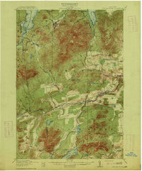 1913 Lyon Mountain1913 Print · USGSThe northern Adirondacks in the pre-war years were a landscape of mountain hamlets and industrial outposts. Genealogists and historians can trace the foundations of Lyon Mountain, locate the Loudell P.O., and follow the Delaware and Hudson RR through the high country.5 unique versions available
 - 1915 Map of Churubusco
 1915 Churubusco1915 Print · USGSNorthern Clinton County is documented here in the early twentieth century, showing a landscape of boundary settlements and mountain lakes. Genealogists can trace family footprints through numerous rural schoolhouses and junctions like Harrigan Corners, Churubusco, and the Halfway House.7 unique versions available
 - 1915 Map of Chateaugay
 1915 Chateaugay1915 Print · USGSNorthern Franklin County appears here during the height of its rail-and-mill era, bordering the international boundary with Canada. Genealogists can trace family footprints through dozens of numbered schoolhouses, the White Church, and industrial sites like Cooks Mill or The Forge.4 unique versions available
 - 1931 Map of Lyon Mountain
 1931 Lyon Mountain1931 Print · USGSThe northern Adirondack mining and timber lands are shown here in the early 1900s, centered on the heights of Lyon Mountain. Researchers can trace the Chateaugay R.R. as it serves industrial sites like Junction Kilns and the settlement at Standish.
 - 1943 Map of Churubusco
 1943 Churubusco1943 Print · USGSClinton County during the early war years remains a landscape of high summits and rural schoolhouses. Family historians can trace ancestral sites near Churubusco or locate properties along the Rutland line and the Great Chazy River.
 - 1943 Map of Chateaugay
 1943 Chateaugay1943 Print · USGSFranklin County sits at the international border during the early years of the war, showing a landscape of small dairy farms and rail-dependent hamlets. Researchers can trace the path of the Rutland Railroad through Chateaugay and find local landmarks like Cooks Mill and Brainardsville.
 - 1948 Map of Ogdensburg, 1973 Print
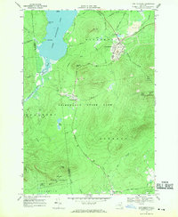
 1948 Ogdensburg1973 Print · USGSThe international border along the St Lawrence River comes to life in the late 1940s, showing the vital rail and water connections between New York and Ontario. Researchers can trace the grounds of St Lawrence University, the massive Camp Drum military reservation, and the historic Rideau River and Canal.2 unique versions available
 - 1950 Map of Lake Champlain
 1950 Lake Champlain1950 Print · USGSThe Lake Champlain valley and its surrounding peaks are captured in detail during the late 1940s, showing the vital rail and road connections between New York and Vermont. Researchers can trace the routes of the Central Vermont Railway or locate old industrial centers like Mineville and Witherbee.2 unique versions available
 - 1951 Map of Ogdensburg
 1951 Ogdensburg1951 Print · USGSThe St. Lawrence frontier and the North Country are captured here during the post-war era, from the river ports to the high Adirondacks. Genealogists and historians can trace the rail-and-river economy through Ogdensburg, the Rutland rail lines, and Potsdam.
 - 1953 Map of Ogdensburg
 1953 Ogdensburg1953 Print · USGSThe North Country and St. Lawrence Valley are shown here in the early fifties, just as the region’s rail-and-river economy remained in full swing. Genealogists and historians can trace family-named corners and rural hubs along the Rutland railroad or locate heritage sites near Ogdensburg, Potsdam, and the St Regis Indian Reservation.
 - 1958 Map of Lake Champlain
 1958 Lake Champlain1958 Print · USGSThe Champlain Valley and surrounding high peaks are captured here in the late fifties, showcasing the cross-border region from the Adirondacks to the Green Mountains. Researchers can trace historic rail routes like the Rutland Railway or locate old valley settlements such as Keeseville and Vergennes.2 unique versions available
 - 1961 Map of Ogdensburg
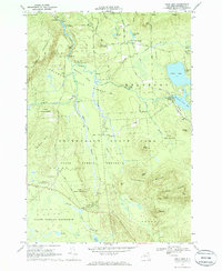
 1961 Ogdensburg1961 Print · USGSThe St. Lawrence valley and the Adirondack high country meet in this early sixties survey during a peak era for rail and river commerce. Genealogists and historians can trace the paths of the New York Central railroad through remote settlements like Wanakena, Conifer, and Piercefield.
 - 1962 Map of Lake Champlain, 1975 Print
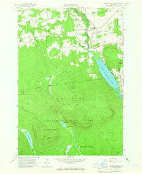
 1962 Lake Champlain1975 Print · USGSLake Champlain and the high peaks of the Adirondacks and Green Mountains are captured here during the mid-twentieth century. Researchers can trace the industrial legacy of the Lyon Mountain Mine and the rail corridors of the Central Vermont RR and Delaware & Hudson RR.3 unique versions available
 - 1964 Map of Ellenburg Center, 1966 Print
 1964 Ellenburg Center1966 Print · USGSNorthern Clinton County in the 1960s was a landscape where the Adirondack wilderness met the farming communities of the Chazy River valley. Researchers can trace family homesteads near Ellenburg Center and Harrigan, or locate lakefront sites at Merrill and Moffitt Island.
 - 1964 Map of Brainardsville, 1966 Print
 1964 Brainardsville1966 Print · USGSFranklin and Clinton counties meet here in the mid-sixties, where the northern Adirondack wilderness transitions into the Chateaugay River valley. Researchers can locate remote burial grounds like Bunker Hill Cem, industrial remnants at Blairs Kiln, and the shoreline of Lower Chateaugay Lake.2 unique versions available
 - 1964 Map of Chasm Falls, 1966 Print
 1964 Chasm Falls1966 Print · USGSFranklin County in the mid-sixties reveals a landscape of working river valleys and the rising peaks of the northern Adirondacks. Researchers can trace the Old Railroad Grade near Teboville or locate local landmarks like the White Ch and River Street Sch.2 unique versions available
 - 1968 Map of Loon Lake, 1970 Print
 1968 Loon Lake1970 Print · USGSFranklin County's high country is captured here in the late sixties as recreation began to define the Adirondacks. Genealogists and historians can trace the foundations of Merrillsville, locate the White Fathers property, and follow an Old Railroad Grade past Lake Kushaqua.2 unique versions available
 - 1968 Map of Ragged Lake, 1970 Print
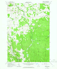
 1968 Ragged Lake1970 Print · USGSFranklin County's remote timber and tanning history is preserved here in the late sixties, just as the forest was reclaiming industrial sites. Trace the path of the Old Railroad Grade to find Upper Kilns and Bryants Mill along the Salmon River.2 unique versions available
 - 1968 Map of Lyon Mountain, 1970 Print
 1968 Lyon Mountain1970 Print · USGSAdirondack mining and wilderness intersect in the late sixties as iron works and rail lines define the rugged terrain. Researchers can trace the industrial layout of Lyon Mountain and Standish, from the St Bernards Ch to the sprawling Mine Dumps.
 - 1968 Map of Owls Head, 1970 Print
 1968 Owls Head1970 Print · USGSThe Adirondack highlands near Duane and Mountain View are captured in the late sixties, showcasing a landscape of high-country lakes and timber-industry remnants. Researchers can locate the Hoose Cem, St Josephs Ch, and old logging routes like Benoit Road.3 unique versions available
 - 1985 Map of Massena
 1985 Massena1985 Print · USGSNorthern New York at the mid-eighties shows a landscape of river-driven industry and high mountain wilderness along the Canadian border. Researchers can trace the legacy of iron working and milling in Brasher Iron Works or follow the Raquette River through Massena and Potsdam.
 - 1986 Map of Lake Champlain North
 1986 Lake Champlain North1986 Print · USGSThe Lake Champlain borderlands in the mid-1980s show a mix of mountain villages and busy island shorelines. Researchers can trace the Delaware and Hudson RR through Plattsburgh or locate old rural sites like Mooers Forks and St Josephs Cem.2 unique versions available
Showing maps 1-25 of 61
Top cities near Bellmont
- Malone historical maps
- Malone historical maps
- Dannemora historical maps
- Saranac historical maps
- Ellenburg historical maps
- Chateaugay historical maps
See more
Top neighborhoods of Bellmont
- Bellmont Center historical maps
- Mountain View historical maps
- Owls Head historical maps
- Porcaville historical maps
- Brainardsville historical maps
- Bryants Mill historical maps
See more
Frequently asked questions
- What are the different types of historical maps available for Bellmont?
- What is the oldest map of Bellmont?
- Where can I purchase historical maps of Bellmont for my home or office?
- Where can I download high-res historical maps of Bellmont?
- Are there historical topographic maps available for Bellmont?
- Is there historical aerial imagery available for Bellmont?
- Where are historical maps of Bellmont sourced from?