
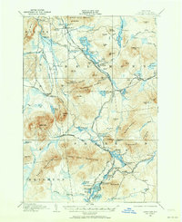
1906 Map of Loon Lake
USGS Topo · Published 1958About this map
Loon Lake Mountains and the Sable Mountains dominate this early 20th-century landscape, where a sophisticated rail network supported a burgeoning leisure and industrial economy. The New York Central and Hudson River and the Chateaugay and Lake Placid railroads intersect at the heart of this region, serving remote mountain outposts and seasonal destinations. Settlements like Loon Lake PO and Inman PO appear alongside established landmarks such as the Hunter Home and the rural community of Merrillville.
Find a feature on this map
118 named features on this map. Tap any name to fly to it.
Don’t see what you’re looking for? This feature index may not catch every label — zoom into the map to look around manually.
Map Details
Editions of this 1906 Loon Lake Map
2 editions found
Other maps of this area

1896 · Lake Placid
USGS Topo · 1:62,500

1898 · Lake Placid
USGS Topo · 1:62,500

1902 · Saranac
USGS Topo · 1:62,500

1904 · Saranac
USGS Topo · 1:62,500

1905 · Saint Regis
USGS Topo · 1:62,500

1908 · Loon Lake
USGS Topo · 1:62,500

1911 · Lyon Mountain
USGS Topo · 1:62,500

1913 · Lyon Mountain
USGS Topo · 1:62,500

1915 · Churubusco
USGS Topo · 1:62,500

1915 · Chateaugay
USGS Topo · 1:62,500