
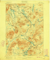
1902 Map of Saranac
USGS Topo · Published 1953About this map
Saranac Lake serves as the focal point of this Adirondack region at the turn of the century, where the arrival of rail infrastructure began to transform local industry and tourism. The map illustrates a dense network of water bodies, including Lower Saranac Lake and Rainbow Lake, connected by the early operations of the Adirondack Division and the New York Central and Hudson River R. R. These lines facilitated the growth of logging and resort communities like Paul Smiths and Bloomingdale.
Find a feature on this map
76 named features on this map. Tap any name to fly to it.
Don’t see what you’re looking for? This feature index may not catch every label — zoom into the map to look around manually.
Map Details
Editions of this 1902 Saranac Map
This is the sole edition of this map. No revisions or reprints were ever made.
Other maps of this area

1895 · Mt. Marcy
USGS Topo · 1:62,500

1896 · Lake Placid
USGS Topo · 1:62,500

1898 · Lake Placid
USGS Topo · 1:62,500

1902 · Mt. Marcy
USGS Topo · 1:62,500

1904 · Saranac
USGS Topo · 1:62,500

1904 · Santanoni
USGS Topo · 1:62,500

1904 · Long Lake
USGS Topo · 1:62,500

1905 · Saint Regis
USGS Topo · 1:62,500
1906 · Loon Lake
USGS Topo · 1:62,500
1908 · Loon Lake
USGS Topo · 1:62,500