1970s Maps of Harrietstown, New York
Explore 9 historic maps of Harrietstown from the 1970s. These maps offer a rare glimpse into what life looked like during the 1970s — showing old roads, neighborhoods, homes, and landmarks that have changed or disappeared over time.
Whether you're researching your family's past, planning a metal detecting trip, or studying how Harrietstown's landscape evolved across the 1970s, these high-resolution maps are a powerful tool for exploring the history of this region.
- Focus on a specific era: All maps on this page are from the 1970s, giving you a focused view of this time period.
- See what’s changed: Compare century-old streets, trails, and buildings to today's modern landscape using overlays and satellite layers.
- Research with precision: Use these maps for genealogy, historical research, land use analysis, or educational projects.
- View, download, or print: Maps are fully viewable online in high resolution, and can be downloaded or printed for your own records.
Start exploring Harrietstown's history through authentic maps from the 1970s. This is your window into the past.
Harrietstown, NY maps
(9)- 1978 Map of Bloomingdale
 1978 Bloomingdale1978 Print · USGSThe Adirondack High Peaks region during the late 1970s shows a landscape of mountain hamlets and sprawling lakes. Local researchers can trace family names and institutions from Paul Smiths College to quiet burial grounds like Mountain View Cemetery and St Johns Cem.
 - 1978 Map of Saranac Lake
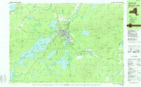 1978 Saranac Lake1978 Print · USGSSaranac Lake and its surrounding mountain wilderness are captured in the late seventies as a hub of health, education, and recreation. Researchers can trace local history at St Bernards Cem, the settlement of Trudeau, and the Correctional Institution at Ray Brook.
 - 1978 Map of Ampersand Lake, 1979 Print
 1978 Ampersand Lake1979 Print · USGSThe High Peaks wilderness in the late seventies is captured here at the junction of Franklin and Essex Counties. Outdoor historians and researchers can trace the Northville Placid Trail to landmarks like Wanika Falls Shelter, Duck Hole, and the peaks of Seward Mountain.2 unique versions available
 - 1979 Map of Kempshall Mtn
 1979 Kempshall Mtn1979 Print · USGSThe central Adirondack wilderness comes alive in the late seventies, focused on the deep waters of Long Lake. Trace the primitive Northville Placid Trail past remote landmarks like the Lookout Tower and Shattuck Clearing.2 unique versions available
 - 1979 Map of Saranac Lake
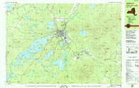 1979 Saranac Lake1979 Print · USGSSaranac Lake and the surrounding Adirondack wilderness appear here in the late seventies as the region prepared for international athletics. Researchers can trace the Adirondack rail line or locate landmarks like Pine Ridge Cem and the Olympic Village.2 unique versions available
 - 1979 Map of Tupper Lake
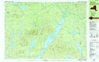
 1979 Tupper Lake1979 Print · USGSThe village of Tupper Lake and the central Adirondacks are captured here in the late seventies as the region balanced local industry with wilderness preservation. Genealogists can trace family sites at Holy Name Cem or locate the former Quinn Sch and the remote outpost at Axton Landing.2 unique versions available
 - 1979 Map of Saint Regis Mtn
 1979 Saint Regis Mtn1979 Print · USGSFranklin County's high peaks and interconnected lakes are captured here in the late seventies as the region balanced wilderness and settlement. Researchers can trace historic locations like Keese Mill, the lakeside community of Paul Smiths, and the rugged trails leading to Saint Regis Mtn.2 unique versions available
 - 1979 Map of Santanoni Peak
 1979 Santanoni Peak1979 Print · USGSThe High Peaks wilderness meets industrial history in the late seventies near the Santanoni Mountains. Researchers can locate the Old MacIntyre Furnace, trace the Northville Placid Trail, and see the footprint of the Tahawus mining operations.
 - 1979 Map of Upper Saranac Lake
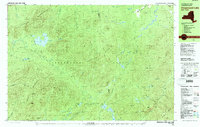
 1979 Upper Saranac Lake1979 Print · USGSThe northern Adirondacks in the late seventies show a landscape of dense timber and interconnected waterways. Researchers can locate family landmarks at Saranac Inn, trace the Old Railroad Grade, and find the Adirondack Fish Hatchery.
End of results
Showing maps 1-9 of 9
Top cities near Harrietstown
- North Elba historical maps
- Tupper Lake historical maps
- Saranac Lake historical maps
- Tupper Lake historical maps
- Saint Armand historical maps
- Brighton historical maps
See more
Top neighborhoods of Harrietstown
- McMasters Crossing historical maps
- Lake Clear historical maps
- Upper Saint Regis historical maps
- Wawbeek historical maps
- Lake Colby historical maps
Frequently asked questions
- What are the different types of historical maps available for Harrietstown?
- What is the oldest map of Harrietstown?
- Where can I purchase historical maps of Harrietstown for my home or office?
- Where can I download high-res historical maps of Harrietstown?
- Are there historical topographic maps available for Harrietstown?
- Is there historical aerial imagery available for Harrietstown?
- Where are historical maps of Harrietstown sourced from?