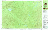
1978 Map of Ampersand Lake
USGS Topo · Published 1979About this map
Ampersand Mountains and the Seward Mountains dominate this 1978 survey of the High Peaks region, capturing the remote interior of the Adirondack Park across the boundary of Franklin and Essex Counties. The map detail centers on the namesake Ampersand Lake and the high-elevation drainage systems of the Chubb River and Moose River. For hikers and local historians, the sheet documents the established route of the Northville Placid Trail as it passes through the mountain gaps, providing specific locations for the Wanika Falls Shelter and a remote Ranger Station near Duck Hole. The terrain is defined by dramatic passes like Indian Pass and Ouluska Pass, which served as critical navigation points through the dense wilderness. Scattered water bodies such as White Lily Pond, Moose Pond, and the Wallface Ponds highlight the complex glacial topography that characterizes this protected forest preserve.
Find a feature on this map
58 named features on this map. Tap any name to fly to it.
Don’t see what you’re looking for? This feature index may not catch every label — zoom into the map to look around manually.
Map Details
Editions of this 1978 Ampersand Lake Map
2 editions found
Other maps of this area

1895 · Mt. Marcy
USGS Topo · 1:62,500

1896 · Lake Placid
USGS Topo · 1:62,500

1898 · Lake Placid
USGS Topo · 1:62,500

1902 · Mt. Marcy
USGS Topo · 1:62,500

1902 · Saranac
USGS Topo · 1:62,500

1904 · Saranac
USGS Topo · 1:62,500

1904 · Santanoni
USGS Topo · 1:62,500

1904 · Long Lake
USGS Topo · 1:62,500

1905 · Saint Regis
USGS Topo · 1:62,500

1948 · Ogdensburg
USGS Topo · 1:250,000