1990s Maps of Caroga, New York
Explore 2 historic maps of Caroga from the 1990s. These maps offer a rare glimpse into what life looked like during the 1990s — showing old roads, neighborhoods, homes, and landmarks that have changed or disappeared over time.
Whether you're researching your family's past, planning a metal detecting trip, or studying how Caroga's landscape evolved across the 1990s, these high-resolution maps are a powerful tool for exploring the history of this region.
- Focus on a specific era: All maps on this page are from the 1990s, giving you a focused view of this time period.
- See what’s changed: Compare century-old streets, trails, and buildings to today's modern landscape using overlays and satellite layers.
- Research with precision: Use these maps for genealogy, historical research, land use analysis, or educational projects.
- View, download, or print: Maps are fully viewable online in high resolution, and can be downloaded or printed for your own records.
Start exploring Caroga's history through authentic maps from the 1990s. This is your window into the past.
Caroga, NY maps
(2)- 1997 Map of Canada Lake, 2000 Print
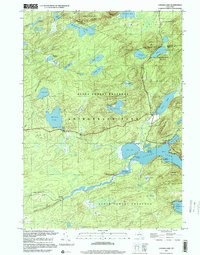 1997 Canada Lake2000 Print · USGSThe Adirondacks in the late 1990s remained a landscape of dense water networks and protected forests at the Fulton-Hamilton line. Trace the shorelines of Canada Lake and Pine Lake, or locate remote landmarks like Stewart Landing and Waters Millpond.
 - 1997 Map of Caroga Lake, 2000 Print
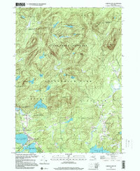 1997 Caroga Lake2000 Print · USGSCaroga Lake and the southern Adirondacks are captured here in the late 1990s as a landscape of mountain summits and glacial lakes. Researchers can trace local history through the Union Sch in Wheelerville and old family-named landmarks like St Josephs Cem and Holmes Lake Road.
End of results
Showing maps 1-2 of 2
Top cities near Caroga
- Gloversville historical maps
- Johnstown historical maps
- Johnstown historical maps
- Mayfield historical maps
- Amsterdam historical maps
- Minden historical maps
See more
Top neighborhoods of Caroga
- Glasgow Mills historical maps
- North Bush historical maps
- Wheelerville historical maps
- Newkirk historical maps
- Canada Lake historical maps
- Caroga Lake historical maps
Frequently asked questions
- What are the different types of historical maps available for Caroga?
- What is the oldest map of Caroga?
- Where can I purchase historical maps of Caroga for my home or office?
- Where can I download high-res historical maps of Caroga?
- Are there historical topographic maps available for Caroga?
- Is there historical aerial imagery available for Caroga?
- Where are historical maps of Caroga sourced from?