Old Maps of Perth, New York for Genealogy
Trace your family roots with 65 historic maps of Perth. These high-res maps reveal old neighborhoods, homesites, landmarks, and streets — helping you uncover where your ancestors lived and how the area evolved over time.
- Explore historic neighborhoods: Identify where your relatives may have lived in the 1800s or 1900s.
- Compare maps over time: Trace the changes in streets, buildings, and landmarks for multi-generational research.
- Perfect for genealogy & ancestry research: Used by family historians and researchers to map out lineage and migration.
These maps are an incredible resource for exploring your personal connection to Perth's past.
Perth, NY maps
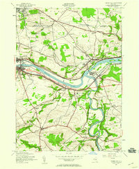
(65)- 1895 Map of Amsterdam
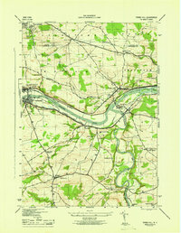
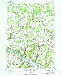
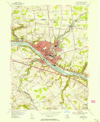
 1895 Amsterdam1895 Print · USGSThe Mohawk River valley thrives in the late nineteenth century as a corridor of heavy rail and canal traffic. Trace the historic paths of the Erie Canal and West Shore R.R. past Amsterdam and the old Hoffman Ferry crossing.7 unique versions available
 - 1896 Map of Fonda
 1896 Fonda1896 Print · USGSThe Mohawk Valley was a technological corridor in the 1890s, defined by the convergence of major rail lines and the Erie Canal. Genealogists and historians can trace the old post offices and hamlet life at Yatesville Randall P.O., Auriesville, and Rural Grove.
 - 1898 Map of Fonda
 1898 Fonda1898 Print · USGSThe Mohawk Valley at the close of the 19th century was a powerhouse of transit and industry. Genealogists and historians can trace the bustling Erie Canal corridor through Fonda, the upland reaches of Charleston, and the path of the West Shore R. R.
 - 1899 Map of Broadalbin, 1954 Print
 1899 Broadalbin1954 Print · USGSFulton and Saratoga counties are shown here just before the turn of the century as the local economy balanced rail transport and river-powered industry. Genealogists can trace family roots through numerous mill hamlets and settlements like Northampton, Vail Mills, and Osborn Bridge.
 - 1902 Map of Broadalbin
 1902 Broadalbin1902 Print · USGSThe Sacandaga River valley is shown here at the turn of the century, prior to the major hydroelectric projects that reshaped this Fulton County landscape. Genealogists can trace early homesteads and milling sites near Vail Mills, Hagedorns Mills, and the Sacandaga Park rail terminus.9 unique versions available
 - 1902 Map of Fonda
 1902 Fonda1902 Print · USGSThe Mohawk Valley at the close of the nineteenth century reveals a critical junction of the Erie Canal and major railroads. Genealogists and historians can trace old homesteads and local centers like Auriesville, Sammonsville, and the remote Charleston Four Corners.8 unique versions available
 - 1903 Map of Gloversville
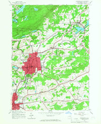
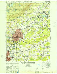
 1903 Gloversville1903 Print · USGSGloversville and Johnstown anchor this turn-of-the-century survey as the region's industrial heart, surrounded by the growing Adirondack resort and timber lands. Genealogists and historians can trace the Electric R.R. or locate historic markers like the Battle Monument and old hamlets like Bleecker Center.8 unique versions available
 - 1931 Map of Amsterdam
 1931 Amsterdam1931 Print · USGSThe Mohawk Valley thrives at the height of its rail and canal era in the late twenties and early thirties. Genealogists can trace family names through dozens of rural schools and churches, from St Marys Ch to the quiet hamlets of Mariaville and Scotch Bush.3 unique versions available
 - 1943 Map of Gloversville
 1943 Gloversville1943 Print · USGSGloversville and Johnstown serve as the industrial anchors of this Adirondack foothills region during the early twentieth century. Genealogists and historians can trace the paths of the Electric R. R. and locate family landmarks like Kingsboro, Bleecker, and the Battle Monument.
 - 1944 Map of Tribes Hill, 1959 Print
 1944 Tribes Hill1959 Print · USGSThe Mohawk Valley's transition into the interstate era is documented here as the new thruway cuts across traditional canal and rail corridors. Genealogists and local historians can trace family-named sites like Wycoff Cem, Switzer Hill, and the Cadaughrity Sch.2 unique versions available
 - 1945 Map of Galway, 1962 Print
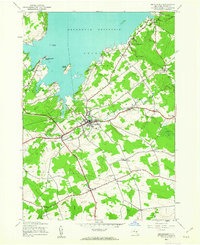
 1945 Galway1962 Print · USGSSaratoga County's rural crossroads and milling hamlets are frozen in time just after the war. Local historians can trace family-named landmarks like Bunn Corners, locate the County Sanatorium, and explore settlements near Lake Galway.
 - 1945 Map of Broadalbin, 1963 Print
 1945 Broadalbin1963 Print · USGSFulton County settlements and the southern reaches of the Adirondack Park are captured here just after the war. Family researchers can trace ancestors through namesake locations like Honeywell Corners, Yates Cem, and rural schoolhouses including Black Street Sch.
 - 1945 Map of Gloversville, 1966 Print
 1945 Gloversville1966 Print · USGSGloversville and Johnstown are shown in high detail during the mid-forties, capturing the industrial and civic heart of Fulton County. Researchers can trace family roots at St Patricks Cem, locate the old County Home, or find vanished schoolhouses like Hale Mills School.
 - 1946 Map of Broadalbin
 1946 Broadalbin1946 Print · USGSFulton County appears at the edge of the Adirondacks just after the war, showing the local impact of the Sacandaga Reservoir. Researchers can trace rural school districts like Black Street Sch and historic transport lines including the Fonda Johnstown and Gloversville.
 - 1946 Map of Gloversville
 1946 Gloversville1946 Print · USGSFulton County industrial centers and rural outskirts are captured here just after the war. Local historians can trace the F J & G RR through Gloversville, find family plots at Prospect Hill Cem, or locate rural landmarks like Dennies Crossing.
 - 1946 Map of Tribes Hill
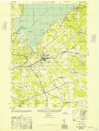
 1946 Tribes Hill1946 Print · USGSThe Mohawk Valley in the mid-1940s reveals a landscape shaped by centuries of transit and settlement along the water. Researchers can trace the path of the Abandoned Erie Canal or find family landmarks like the Wycoff Cem and Cadaughrity Sch.
 - 1947 Map of Amsterdam, 1963 Print
 1947 Amsterdam1963 Print · USGSThe Mohawk Valley and its surrounding uplands are captured here in the late 1940s, highlighting the heavy industrial and transit hubs of the day. Researchers can trace the legacy of the Erie Canal, find numerous rural schoolhouses like Log City Sch, and locate the Duanesburg Churches.3 unique versions available
 - 1948 Map of Binghamton, 1980 Print
 1948 Binghamton1980 Print · USGSCentral New York and the Southern Tier thrive in the late 1940s as a hub of rail traffic and mountain industry. Researchers can trace historic transit lines like the Erie Railroad through Binghamton or find old valley settlements near Oneonta and Delhi.
 - 1949 Map of Amsterdam
 1949 Amsterdam1949 Print · USGSThe Mohawk Valley corridor thrives in the late 1940s as a vital artery for rail, canal, and industry. Researchers can trace the legacy of local education and faith at Duanesburg Churches, School No 7, and the Montgomery County Sanatorium.2 unique versions available
 - 1950 Map of Binghamton
 1950 Binghamton1950 Print · USGSBinghamton and the surrounding Southern Tier are shown in the mid-century era, highlighting the intricate rail and river networks that drove local industry. Researchers can trace the path of the Erie Railroad and locate landmarks from Otsego Lake to Sidney Mountain.2 unique versions available
 - 1950 Map of Utica, 1951 Print
 1950 Utica1951 Print · USGSCentral New York in the post-war era showcases the industrial Mohawk Valley and the pristine Adirondack interior. Researchers can trace transportation networks like the New York Central Railroad and find early Cold War sites such as Griffiss Air Force Base.
 - 1954 Map of Pattersonville, 1956 Print
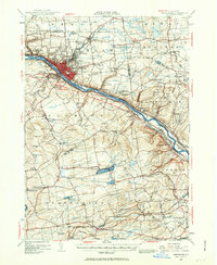
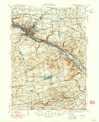
 1954 Pattersonville1956 Print · USGSThe Mohawk River valley near Pattersonville was a bustling corridor of rail and water transit in the mid-1950s. Researchers can trace family history through sites like Woestina Cem and early landmarks like the abandoned Erie Canal and Hoffmans.2 unique versions available
 - 1954 Map of Amsterdam, 1956 Print
 1954 Amsterdam1956 Print · USGSMid-century Amsterdam and the Mohawk Valley are shown here in their industrial prime, centered on a busy river-and-rail corridor. Researchers can trace the layout of vanished neighborhood schools like Milton Avenue Sch or locate ancestors at Green Hill Cemetery and St Marys Cem.4 unique versions available
 - 1957 Map of Utica
 1957 Utica1957 Print · USGSCentral New York and the Adirondack foothills are captured here in the mid-fifties, showing a landscape defined by the Mohawk River corridor and the growing highway system. Genealogists and researchers can trace the rail lines of the New York Central and locate communities from Lowville to Gloversville.
 - 1958 Map of Binghamton
 1958 Binghamton1958 Print · USGSCentral New York in the late fifties was a network of manufacturing cities and river valleys connected by vital rail lines. Genealogists and historians can trace family roots in Oneonta, Norwich, and Cooperstown or locate long-standing farms along Schoharie Creek.
Showing maps 1-25 of 65
Top cities near Perth
- Schenectady historical maps
- Rotterdam historical maps
- Glenville historical maps
- West Glenville historical maps
- Amsterdam historical maps
- Gloversville historical maps
See more
Top neighborhoods of Perth
- West Perth historical maps
- Stairs Corners historical maps
- Beyers Corners historical maps
- West Galway historical maps
Frequently asked questions
- What are the different types of historical maps available for Perth?
- What is the oldest map of Perth?
- Where can I purchase historical maps of Perth for my home or office?
- Where can I download high-res historical maps of Perth?
- Are there historical topographic maps available for Perth?
- Is there historical aerial imagery available for Perth?
- Where are historical maps of Perth sourced from?