1940s Maps of LeRoy, New York
Explore 4 historic maps of LeRoy from the 1940s. These maps offer a rare glimpse into what life looked like during the 1940s — showing old roads, neighborhoods, homes, and landmarks that have changed or disappeared over time.
Whether you're researching your family's past, planning a metal detecting trip, or studying how LeRoy's landscape evolved across the 1940s, these high-resolution maps are a powerful tool for exploring the history of this region.
- Focus on a specific era: All maps on this page are from the 1940s, giving you a focused view of this time period.
- See what’s changed: Compare century-old streets, trails, and buildings to today's modern landscape using overlays and satellite layers.
- Research with precision: Use these maps for genealogy, historical research, land use analysis, or educational projects.
- View, download, or print: Maps are fully viewable online in high resolution, and can be downloaded or printed for your own records.
Start exploring LeRoy's history through authentic maps from the 1940s. This is your window into the past.
LeRoy, NY maps
(4)- 1944 Map of Churchville
 1944 Churchville1944 Print · USGSMonroe and Genesee counties are captured here in the mid-1940s, showing a landscape defined by the New York Central System and Bergen Swamp Wild Life Sanctuary. Researchers can trace rural school districts like School No 9 and settlements at Stone Church or Beulah.
 - 1944 Map of Byron
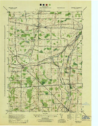
 1944 Byron1944 Print · USGSGenesee County's rural landscape at the height of the Second World War was a thriving network of rail-side hamlets and small school districts. Genealogists and local historians can trace family roots through labeled sites like School No 2, the village of South Byron, and the Bergen Swamp Wild-Life Sanctuary.
 - 1944 Map of Stafford
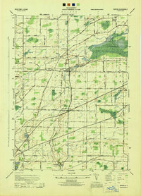
 1944 Stafford1944 Print · USGSWestern New York’s rural landscape is captured here during the mid-1940s, showcasing the intersection of heavy rail and local farming life. Genealogists can locate family-named roads and several rural schoolhouses like School No 8 and School No 11.
 - 1944 Map of Le Roy
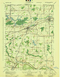
 1944 Le Roy1944 Print · USGSLe Roy and its surrounding townships are shown at the height of the steam-to-diesel rail era, where three major lines intersect. Genealogists can locate family landmarks such as Machpelah Cemetery, Union Corners, and many rural schoolhouses like School No 7.
End of results
Showing maps 1-4 of 4
Top cities near LeRoy
- Greece historical maps
- Gates historical maps
- Chili historical maps
- Ogden historical maps
- Parma historical maps
- Batavia historical maps
See more
Top neighborhoods of LeRoy
Frequently asked questions
- What are the different types of historical maps available for LeRoy?
- What is the oldest map of LeRoy?
- Where can I purchase historical maps of LeRoy for my home or office?
- Where can I download high-res historical maps of LeRoy?
- Are there historical topographic maps available for LeRoy?
- Is there historical aerial imagery available for LeRoy?
- Where are historical maps of LeRoy sourced from?