1990s Maps of Hoffmeister, Morehouse
Explore 2 historic maps of Hoffmeister from the 1990s. These maps offer a rare glimpse into what life looked like during the 1990s — showing old roads, neighborhoods, homes, and landmarks that have changed or disappeared over time.
Whether you're researching your family's past, planning a metal detecting trip, or studying how Hoffmeister's landscape evolved across the 1990s, these high-resolution maps are a powerful tool for exploring the history of this region.
- Focus on a specific era: All maps on this page are from the 1990s, giving you a focused view of this time period.
- See what’s changed: Compare century-old streets, trails, and buildings to today's modern landscape using overlays and satellite layers.
- Research with precision: Use these maps for genealogy, historical research, land use analysis, or educational projects.
- View, download, or print: Maps are fully viewable online in high resolution, and can be downloaded or printed for your own records.
Start exploring Hoffmeister's history through authentic maps from the 1990s. This is your window into the past.
Hoffmeister, Morehouse maps
(2)- 1990 Map of Piseco Lake
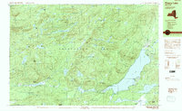 1990 Piseco Lake1990 Print · USGSHamilton County's mountain wilderness and quiet lakefront communities are captured here in the 1990s. Genealogists and researchers can trace the small settlements of Piseco and Rudeston alongside landmarks like Higgins Bay and the local Cem.2 unique versions available
 - 1997 Map of Piseco Lake
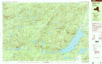 1997 Piseco Lake1997 Print · USGSThe Adirondack forest preserve in the late nineties centers on the waters of Piseco Lake and the Metcalf Range. Researchers can trace the layout of Piseco, Rudeston, and Higgins Bay, or locate remote sites like Mountain Home and the local Cem.
End of results
Showing maps 1-2 of 2
Top cities near Hoffmeister
- Salisbury historical maps
- Webb historical maps
- Fairfield historical maps
- Caroga historical maps
- Ohio historical maps
- Lake Pleasant historical maps
See more
Frequently asked questions
- What are the different types of historical maps available for Hoffmeister?
- What is the oldest map of Hoffmeister?
- Where can I purchase historical maps of Hoffmeister for my home or office?
- Where can I download high-res historical maps of Hoffmeister?
- Are there historical topographic maps available for Hoffmeister?
- Is there historical aerial imagery available for Hoffmeister?
- Where are historical maps of Hoffmeister sourced from?