1980s Maps of German Flatts, New York
Explore 5 historic maps of German Flatts from the 1980s. These maps offer a rare glimpse into what life looked like during the 1980s — showing old roads, neighborhoods, homes, and landmarks that have changed or disappeared over time.
Whether you're researching your family's past, planning a metal detecting trip, or studying how German Flatts's landscape evolved across the 1980s, these high-resolution maps are a powerful tool for exploring the history of this region.
- Focus on a specific era: All maps on this page are from the 1980s, giving you a focused view of this time period.
- See what’s changed: Compare century-old streets, trails, and buildings to today's modern landscape using overlays and satellite layers.
- Research with precision: Use these maps for genealogy, historical research, land use analysis, or educational projects.
- View, download, or print: Maps are fully viewable online in high resolution, and can be downloaded or printed for your own records.
Start exploring German Flatts's history through authentic maps from the 1980s. This is your window into the past.
German Flatts, NY maps
(5)- 1982 Map of Ilion, 1983 Print
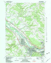 1982 Ilion1983 Print · USGSThe Mohawk Valley corridor thrives in the early eighties as a hub of industry and transit. Genealogists can trace family names at Armory Hill Cemetery and Oak View Cem, or locate landmarks like East Schuyler Ch and the Erie Canal.
 - 1985 Map of Gloversville, 1986 Print
 1985 Gloversville1986 Print · USGSThe southern Adirondacks meet the Mohawk Valley industrial corridor during the mid-eighties, showcasing a landscape of high-country lakes and riverside manufacturing towns. Trace the historical alignment of the Erie Canal and Conrail lines or locate landmarks like the Herkimer Home State Historic Site.2 unique versions available
 - 1985 Map of Amsterdam, 1986 Print
 1985 Amsterdam1986 Print · USGSUpstate New York in the mid-1980s reveals a landscape defined by historic river valleys and expanding interstate corridors. Researchers can trace family sites near Stone Arabia Cemetery or explore the civic centers of Amsterdam and Cooperstown near Otsego Lake.2 unique versions available
 - 1985 Map of Utica, 1986 Print
 1985 Utica1986 Print · USGSThe Mohawk Valley in the mid-eighties shows a landscape of industrial river cities and high-tech military hubs before the post-Cold War transition. Trace the development of Rome and Utica, the operations at Griffiss Air Force Base, and the lakeside activity at Oneida Lake.2 unique versions available
 - 1986 Map of Norwich
 1986 Norwich1986 Print · USGSCentral New York in the mid-eighties was a landscape of deep river valleys and university towns connected by historic rail corridors and state highways. Researchers can trace the rural infrastructure of Norwich and Hamilton, finding landmarks like Colgate University and the Seventh Day Hollow Church.2 unique versions available
End of results
Showing maps 1-5 of 5
Top cities near German Flatts
- Utica historical maps
- New Hartford historical maps
- Herkimer historical maps
- Marcy historical maps
- Ilion historical maps
- Herkimer historical maps
See more
Top neighborhoods of German Flatts
- Dennison Corners historical maps
- Edicks historical maps
- Days Rock historical maps
- Fort Herkimer historical maps
- Ilion historical maps
- Mohawk historical maps
See more
Frequently asked questions
- What are the different types of historical maps available for German Flatts?
- What is the oldest map of German Flatts?
- Where can I purchase historical maps of German Flatts for my home or office?
- Where can I download high-res historical maps of German Flatts?
- Are there historical topographic maps available for German Flatts?
- Is there historical aerial imagery available for German Flatts?
- Where are historical maps of German Flatts sourced from?