1950s Maps of Clayton, New York
Explore 10 historic maps of Clayton from the 1950s. These maps offer a rare glimpse into what life looked like during the 1950s — showing old roads, neighborhoods, homes, and landmarks that have changed or disappeared over time.
Whether you're researching your family's past, planning a metal detecting trip, or studying how Clayton's landscape evolved across the 1950s, these high-resolution maps are a powerful tool for exploring the history of this region.
- Focus on a specific era: All maps on this page are from the 1950s, giving you a focused view of this time period.
- See what’s changed: Compare century-old streets, trails, and buildings to today's modern landscape using overlays and satellite layers.
- Research with precision: Use these maps for genealogy, historical research, land use analysis, or educational projects.
- View, download, or print: Maps are fully viewable online in high resolution, and can be downloaded or printed for your own records.
Start exploring Clayton's history through authentic maps from the 1950s. This is your window into the past.
Clayton, NY maps
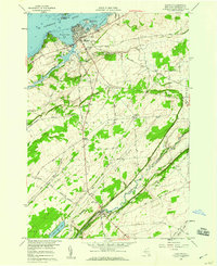
(10)- 1951 Map of Ogdensburg
 1951 Ogdensburg1951 Print · USGSThe St. Lawrence frontier and the North Country are captured here during the post-war era, from the river ports to the high Adirondacks. Genealogists and historians can trace the rail-and-river economy through Ogdensburg, the Rutland rail lines, and Potsdam.
 - 1953 Map of Ogdensburg
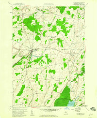
 1953 Ogdensburg1953 Print · USGSThe North Country and St. Lawrence Valley are shown here in the early fifties, just as the region’s rail-and-river economy remained in full swing. Genealogists and historians can trace family-named corners and rural hubs along the Rutland railroad or locate heritage sites near Ogdensburg, Potsdam, and the St Regis Indian Reservation.
 - 1954 Map of Kingston
 1954 Kingston1954 Print · USGSThe international border at the head of the St. Lawrence comes alive in the mid-fifties, showing the interconnected rail and river systems of Ontario and New York. Trace historical routes like the Canadian National RR or find local landmarks such as Thousand Island Park and Tyendinaga Ind. Res.4 unique versions available
 - 1958 Map of Brownville, 1960 Print
 1958 Brownville1960 Print · USGSJefferson County’s agricultural and riverfront landscape is documented here during the late fifties, from the industrial Black River up to the marshy Perch Lake. Genealogists can locate family-named sites like Rouses Cem, Jenkins Sch, and the crossroads at Stone Mills.3 unique versions available
 - 1958 Map of Thousand Island Park, 1960 Print
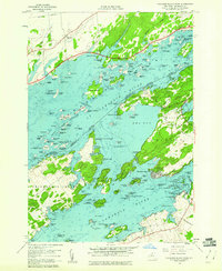 1958 Thousand Island Park1960 Print · USGSThe St. Lawrence River archipelago is captured here in the late fifties, showing the international boundary winding through the islands. Researchers can trace historic riverfront communities like Thousand Island Park or locate the Quarries and remote Cem on GRINDSTONE ISLAND.3 unique versions available
 - 1958 Map of Clayton, 1960 Print
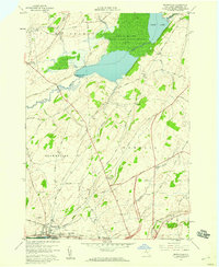
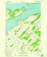
 1958 Clayton1960 Print · USGSJefferson County’s riverfront and agricultural interior are captured here in the late fifties, showcasing the transition from the St Lawrence River docks to rural townships. Genealogists and local historians can trace the New York Central Railroad line or locate the Weaver Cem and Corbin Cem.2 unique versions available
 - 1958 Map of Dexter, 1960 Print
 1958 Dexter1960 Print · USGSThe Lake Ontario shoreline near the mouth of the Black River is captured here in the late fifties. Genealogists and local historians can trace the Old Railroad Grade and locate ancestral sites like Freeman Cem and the General Brown High Sch.3 unique versions available
 - 1958 Map of La Fargeville, 1960 Print
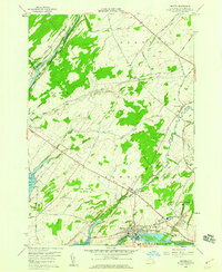
 1958 La Fargeville1960 Print · USGSJefferson County farming and rail life are preserved here in the late fifties, centered on the crossroads of La Fargeville. Researchers can trace ancestral locations through numerous burial sites like St Johns Cem or follow the path of the New York Central railroad.
 - 1958 Map of Saint Lawrence, 1961 Print
 1958 Saint Lawrence1961 Print · USGSThe Thousand Islands region and the international border appear here in the late fifties as a landscape of river navigation and quiet upland farming. Genealogists can trace family names at the Saint Lawrence Cem or locate old homesteads near Warren and Kents.2 unique versions available
 - 1958 Map of Gananoque, 1961 Print
 1958 Gananoque1961 Print · USGSThe international border along the St. Lawrence River is frozen in time here just as mid-century development reached the Thousand Islands. Researchers can trace the Canadian National rail line through Gananoque Junction or locate family landmarks like Legge Hill and Willetsholme.
End of results
Showing maps 1-10 of 10
Top cities near Clayton
- Le Ray historical maps
- Watertown historical maps
- Watertown historical maps
- Brownville historical maps
- Alexandria historical maps
- Pamelia historical maps
See more
Top neighborhoods of Clayton
- Clayton Center historical maps
- Frontenac historical maps
- Lower Town Landing historical maps
- Grindstone historical maps
- Reynolds Corner historical maps
- Grenell historical maps
See more
Frequently asked questions
- What are the different types of historical maps available for Clayton?
- What is the oldest map of Clayton?
- Where can I purchase historical maps of Clayton for my home or office?
- Where can I download high-res historical maps of Clayton?
- Are there historical topographic maps available for Clayton?
- Is there historical aerial imagery available for Clayton?
- Where are historical maps of Clayton sourced from?