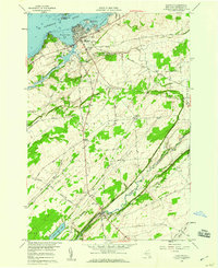
1958 Map of Clayton
USGS Topo · Published 1960About this map
Clayton serves as the focal point for this Thousand Island region survey, situated where the New York Central Railroad meets the St Lawrence River. The village waterfront is densely detailed with piers and docks near French Creek Bay and Washington Island, while the interior transitions to an agricultural landscape. To the south, the settlement of Depauville sits along the Chaumont River, connected to the riverfront by the Depauville Road. Family history researchers can identify several rural burial grounds including Weaver Cem, Corbin Cem, and Dutch Cem scattered across the township. The topography reveals a mix of limestone flats and small elevations like Schnauber Hill, with the local economy of the late 1950s reflected in numerous quarries and the Central Sch serving the local population center.
Find a feature on this map
46 named features on this map. Tap any name to fly to it.
Don’t see what you’re looking for? This feature index may not catch every label — zoom into the map to look around manually.
Map Details
Editions of this 1958 Clayton Map
2 editions found
Other maps of this area

1900 · Clayton
USGS Topo · 1:62,500

1903 · Grindstone
USGS Topo · 1:62,500

1903 · Clayton
USGS Topo · 1:62,500

1903 · Alexandria Bay
USGS Topo · 1:62,500

1903 · Theresa
USGS Topo · 1:62,500

1942 · Chaumont
USGS Topo · 1:31,680

1942 · Sawmill Bay
USGS Topo · 1:31,680

1942 · Clayton
USGS Topo · 1:24,000
1943 · Dexter
USGS Topo · 1:31,680

1943 · Thousand Island Park
USGS Topo · 1:31,680