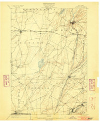
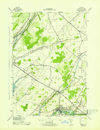
Old Maps of Clayton, New York for Hiking & Exploration
Hike through history with 62 historic maps of Clayton. Explore old trails, ghost towns, and forgotten backroads — perfect for outdoor adventurers and local explorers.
- Rediscover forgotten places: Map out old mining camps, roads, and footpaths that no longer exist on modern maps.
- Layer with modern tools: Combine with LiDAR or satellite views to plan hikes through historical terrain.
- Made for exploration: Popular among hikers, overlanders, and local history lovers.
Use these maps to find adventure and explore the hidden past of Clayton.
Clayton, NY maps
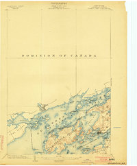
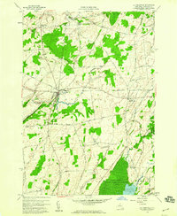
(62)- 1900 Map of Clayton, 1957 Print
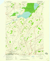
 1900 Clayton1957 Print · USGSThe Thousand Islands region and the St. Lawrence riverfront are captured here at the turn of the century, showing a landscape defined by steam and rail. Genealogists can trace family roots in CLAYTON, Chaumont, and Depauville, or follow the path of the Electric R.R. near Dexter.
 - 1903 Map of Grindstone
 1903 Grindstone1903 Print · USGSThe Thousand Islands at the turn of the century are captured here along the international border as steamboat traffic flourished. Genealogists and historians can trace old resort landings like Thousand Island Park and Fineview or locate several distinct river beacons including Rock I. L.H. and Lindoe L.H..4 unique versions available
 - 1903 Map of Clayton
 1903 Clayton1903 Print · USGSJefferson County's Thousand Islands region and Lake Ontario shoreline are documented here just after the turn of the century. Genealogists and historians can trace the rail lines connecting Clayton and Chaumont, or locate old post offices in Depauville and Rosiere.6 unique versions available
 - 1903 Map of Theresa
 1903 Theresa1903 Print · USGSJefferson County at the turn of the century was a bustling network of dairy farms and rail junctions. You can trace the path of the Rome Watertown and Ogdensburg Div. through Evans Mills or locate early settlements like Stone Mills and Leraysville.8 unique versions available
 - 1942 Map of Sawmill Bay
 1942 Sawmill Bay1942 Print · USGSThe Thousand Islands region along the New York-Ontario border is captured here during the early 1940s. Researchers can trace the rural landscape of Jefferson County through sites like Sand Bay Cem, the Wolfe Island L H, and local schoolhouses like School No 19.
 - 1942 Map of Clayton, 1957 Print
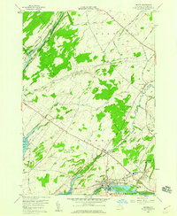
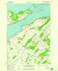
 1942 Clayton1957 Print · USGSThe Thousand Islands region appears at a mid-century peak in this survey of the riverfront and agricultural interior. Local historians can trace the foundations of the community through its many numbered rural schools and family burial sites like Corbin Cem and Dutch Cem.
 - 1943 Map of Dexter
 1943 Dexter1943 Print · USGSJefferson County life in the early 1940s is centered on the riverfront industry and rail connections of the lake plain. Genealogists can locate family burial grounds like Freeman Cem and identify numerous rural schoolhouses including School No 16 and School No 8.
 - 1943 Map of Thousand Island Park
 1943 Thousand Island Park1943 Print · USGSThe Thousand Islands region along the New York-Ontario border is captured here during the 1940s, showing the intricate island communities of the St. Lawrence River. Trace local history through landmark schools like Spicer Bay Sch and the distinct landings of Grindstone Island.
 - 1943 Map of Clayton
 1943 Clayton1943 Print · USGSThe Thousand Islands region and the St. Lawrence riverfront are captured here in the early 1940s. Genealogists and local historians can trace the rural school system and family burial grounds, including School No 2, Dutch Cem, and the village of Depauville.
 - 1943 Map of Lafargeville
 1943 Lafargeville1943 Print · USGSJefferson County was still a landscape of scattered rural schools and rail-fed hamlets during the early years of World War II. Researchers can trace ancestral locations through several family-named burial grounds like Hinman Cem and the rail corridors of the New York Central.
 - 1943 Map of Brownville
 1943 Brownville1943 Print · USGSJefferson County during the mid-forties remains a landscape of traditional rural districts and small hamlets connected by the New York Central line. Researchers can trace the layout of early school districts and secluded burial sites like Taylor Cem or Sandy Loam Cem.
 - 1943 Map of Grindstone
 1943 Grindstone1943 Print · USGSThe Thousand Islands shoreline in the early 1940s reveals a cross-border landscape of island farms and river navigation. Researchers can trace the family footprints at Grindstone (PO), the rural School No 15, and the lighthouse at Red Horse Rock LH.
 - 1948 Map of Theresa, 1953 Print
 1948 Theresa1953 Print · USGSJefferson County's rural landscape is captured here in the late 1940s as military expansion and river-based industry shaped the region. Researchers can trace family roots through numerous sites like St Marys Cemetery, Bacon School, and the Pine Camp Military Reservation.
 - 1948 Map of Ogdensburg, 1973 Print
 1948 Ogdensburg1973 Print · USGSThe international border along the St Lawrence River comes to life in the late 1940s, showing the vital rail and water connections between New York and Ontario. Researchers can trace the grounds of St Lawrence University, the massive Camp Drum military reservation, and the historic Rideau River and Canal.2 unique versions available
 - 1951 Map of Ogdensburg
 1951 Ogdensburg1951 Print · USGSThe St. Lawrence frontier and the North Country are captured here during the post-war era, from the river ports to the high Adirondacks. Genealogists and historians can trace the rail-and-river economy through Ogdensburg, the Rutland rail lines, and Potsdam.
 - 1953 Map of Ogdensburg
 1953 Ogdensburg1953 Print · USGSThe North Country and St. Lawrence Valley are shown here in the early fifties, just as the region’s rail-and-river economy remained in full swing. Genealogists and historians can trace family-named corners and rural hubs along the Rutland railroad or locate heritage sites near Ogdensburg, Potsdam, and the St Regis Indian Reservation.
 - 1954 Map of Kingston
 1954 Kingston1954 Print · USGSThe international border at the head of the St. Lawrence comes alive in the mid-fifties, showing the interconnected rail and river systems of Ontario and New York. Trace historical routes like the Canadian National RR or find local landmarks such as Thousand Island Park and Tyendinaga Ind. Res.4 unique versions available
 - 1958 Map of Brownville, 1960 Print
 1958 Brownville1960 Print · USGSJefferson County’s agricultural and riverfront landscape is documented here during the late fifties, from the industrial Black River up to the marshy Perch Lake. Genealogists can locate family-named sites like Rouses Cem, Jenkins Sch, and the crossroads at Stone Mills.3 unique versions available
 - 1958 Map of Thousand Island Park, 1960 Print
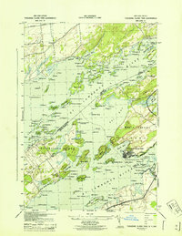
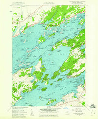 1958 Thousand Island Park1960 Print · USGSThe St. Lawrence River archipelago is captured here in the late fifties, showing the international boundary winding through the islands. Researchers can trace historic riverfront communities like Thousand Island Park or locate the Quarries and remote Cem on GRINDSTONE ISLAND.3 unique versions available
 - 1958 Map of Clayton, 1960 Print
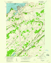 1958 Clayton1960 Print · USGSJefferson County’s riverfront and agricultural interior are captured here in the late fifties, showcasing the transition from the St Lawrence River docks to rural townships. Genealogists and local historians can trace the New York Central Railroad line or locate the Weaver Cem and Corbin Cem.2 unique versions available
 - 1958 Map of Dexter, 1960 Print
 1958 Dexter1960 Print · USGSThe Lake Ontario shoreline near the mouth of the Black River is captured here in the late fifties. Genealogists and local historians can trace the Old Railroad Grade and locate ancestral sites like Freeman Cem and the General Brown High Sch.3 unique versions available
 - 1958 Map of La Fargeville, 1960 Print
 1958 La Fargeville1960 Print · USGSJefferson County farming and rail life are preserved here in the late fifties, centered on the crossroads of La Fargeville. Researchers can trace ancestral locations through numerous burial sites like St Johns Cem or follow the path of the New York Central railroad.
 - 1958 Map of Saint Lawrence, 1961 Print
 1958 Saint Lawrence1961 Print · USGSThe Thousand Islands region and the international border appear here in the late fifties as a landscape of river navigation and quiet upland farming. Genealogists can trace family names at the Saint Lawrence Cem or locate old homesteads near Warren and Kents.2 unique versions available
 - 1958 Map of Gananoque, 1961 Print
 1958 Gananoque1961 Print · USGSThe international border along the St. Lawrence River is frozen in time here just as mid-century development reached the Thousand Islands. Researchers can trace the Canadian National rail line through Gananoque Junction or locate family landmarks like Legge Hill and Willetsholme.
 - 1961 Map of Ogdensburg
 1961 Ogdensburg1961 Print · USGSThe St. Lawrence valley and the Adirondack high country meet in this early sixties survey during a peak era for rail and river commerce. Genealogists and historians can trace the paths of the New York Central railroad through remote settlements like Wanakena, Conifer, and Piercefield.
Showing maps 1-25 of 62
Top cities near Clayton
- Le Ray historical maps
- Watertown historical maps
- Watertown historical maps
- Brownville historical maps
- Alexandria historical maps
- Pamelia historical maps
See more
Top neighborhoods of Clayton
- Clayton Center historical maps
- Frontenac historical maps
- Lower Town Landing historical maps
- Grindstone historical maps
- Reynolds Corner historical maps
- Grenell historical maps
See more
Frequently asked questions
- What are the different types of historical maps available for Clayton?
- What is the oldest map of Clayton?
- Where can I purchase historical maps of Clayton for my home or office?
- Where can I download high-res historical maps of Clayton?
- Are there historical topographic maps available for Clayton?
- Is there historical aerial imagery available for Clayton?
- Where are historical maps of Clayton sourced from?