2020s Maps of Lyonsdale, New York
Explore 6 historic maps of Lyonsdale from the 2020s. These maps offer a rare glimpse into what life looked like during the 2020s — showing old roads, neighborhoods, homes, and landmarks that have changed or disappeared over time.
Whether you're researching your family's past, planning a metal detecting trip, or studying how Lyonsdale's landscape evolved across the 2020s, these high-resolution maps are a powerful tool for exploring the history of this region.
- Focus on a specific era: All maps on this page are from the 2020s, giving you a focused view of this time period.
- See what’s changed: Compare century-old streets, trails, and buildings to today's modern landscape using overlays and satellite layers.
- Research with precision: Use these maps for genealogy, historical research, land use analysis, or educational projects.
- View, download, or print: Maps are fully viewable online in high resolution, and can be downloaded or printed for your own records.
Start exploring Lyonsdale's history through authentic maps from the 2020s. This is your window into the past.
Lyonsdale, NY maps
(6)- 2023 Map of Copper Lake, 2023 Print
 2023 Copper Lake2023 Print · USGSThe Adirondack wilderness of Lewis County is captured here in the early twenty-first century, showing a landscape defined by its waterways and trails. Researchers can trace the path of the Glenfield Railroad Trl or locate remote sites like Pine Lake and Little Pine Lake.
 - 2023 Map of Brantingham, 2023 Print
 2023 Brantingham2023 Print · USGSThe western Adirondack foothills come alive in this survey of the lake-strewn landscape around Brantingham and Greig. Genealogists can locate Sands Cem and Abbey Cem while tracing waterways like the Black River and Otter Creek.
 - 2023 Map of Woodgate, 2023 Print
 2023 Woodgate2023 Print · USGSOneida County wilderness and the Adirondack fringe are captured here in the early twenty-first century. Researchers can trace forest trails and local landmarks like Woodgate Cem, the settlement of Woodgate, and the shores of White Lake.
 - 2023 Map of McKeever, 2023 Print
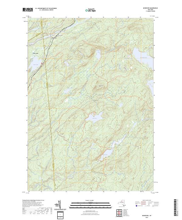 2023 McKeever2023 Print · USGSThe Adirondacks in the early twenty-first century are seen here through a dense network of forest trails and remote lakes. Trace wilderness routes like Stone Dam Trl or explore the settlements of McKeever and Otter Lake.
 - 2023 Map of Port Leyden, 2023 Print
 2023 Port Leyden2023 Print · USGSThe confluence of the Black and Moose Rivers at Lyons Falls and Port Leyden remains central to this Lewis County landscape. Trace family roots and local industry through Wildwood Cem, the settlement at Talcottville, and the waters of Agers Falls.
 - 2023 Map of Thendara, 2023 Print
 2023 Thendara2023 Print · USGSThe Adirondack wilderness near the Herkimer and Lewis county line comes alive in this 2023 survey of the Moose River country. Trace historic routes and waterway access through settlements like Minnehaha and Thendara, or locate landmarks like Moose River Mountain and the Browns Tract Trl.
End of results
Showing maps 1-6 of 6
Top cities near Lyonsdale
- Lee historical maps
- Lowville historical maps
- Boonville historical maps
- Lowville historical maps
- New Bremen historical maps
- Russia historical maps
See more
Top neighborhoods of Lyonsdale
- Fowlersville historical maps
- Goulds Mill historical maps
- Shuetown historical maps
- Kosterville historical maps
- Moose River historical maps
Frequently asked questions
- What are the different types of historical maps available for Lyonsdale?
- What is the oldest map of Lyonsdale?
- Where can I purchase historical maps of Lyonsdale for my home or office?
- Where can I download high-res historical maps of Lyonsdale?
- Are there historical topographic maps available for Lyonsdale?
- Is there historical aerial imagery available for Lyonsdale?
- Where are historical maps of Lyonsdale sourced from?