1900-1909 Maps of Martinsburg, New York
Explore 5 historic maps of Martinsburg from 1900-1909. These maps offer a rare glimpse into what life looked like during the 1900s — showing old roads, neighborhoods, homes, and landmarks that have changed or disappeared over time.
Whether you're researching your family's past, planning a metal detecting trip, or studying how Martinsburg's landscape evolved across the 1900s, these high-resolution maps are a powerful tool for exploring the history of this region.
- Focus on a specific era: All maps on this page are from the 1900s, giving you a focused view of this time period.
- See what’s changed: Compare century-old streets, trails, and buildings to today's modern landscape using overlays and satellite layers.
- Research with precision: Use these maps for genealogy, historical research, land use analysis, or educational projects.
- View, download, or print: Maps are fully viewable online in high resolution, and can be downloaded or printed for your own records.
Start exploring Martinsburg's history through authentic maps from the 1900s. This is your window into the past.
Martinsburg, NY maps
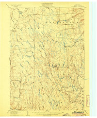
(5)- 1902 Map of Carthage
 1902 Carthage1902 Print · USGSUpper New York at the turn of the century shows a landscape of river-powered industry and sprawling hill farms. Genealogists can trace family names and old crossroads from Champion Huddle to Gardners Corners, while rail historians can follow the R. W. and O. Div. through the Black River valley.
 - 1904 Map of Carthage
 1904 Carthage1904 Print · USGSJefferson and Lewis Counties at the turn of the century show a landscape defined by the Black River valley and its busy rail lines. Genealogists can trace early homesteads in rural outposts like Champion Huddle, Windecker, and Gardners Corners.6 unique versions available
 - 1905 Map of Port Leyden
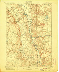
 1905 Port Leyden1905 Print · USGSLewis County at the start of the twentieth century shows a landscape shaped by the Black River Canal and burgeoning timber railroads. Genealogists and historians can trace riverside industry at Goulds Mill, the remote settlement of Partridgeville, and the transit hub at Leyden Station PO.2 unique versions available
 - 1906 Map of Highmarket
 1906 Highmarket1906 Print · USGSLewis County at the turn of the century shows a landscape of timber hamlets and early logging railroads deep in the Tug Hill region. Genealogists and researchers can trace the old paths of the Glenfield and Western RR or locate the sites of Michigan Mills and Highmarket.6 unique versions available
 - 1907 Map of Port Leyden
 1907 Port Leyden1907 Print · USGSPort Leyden and the Black River valley are shown here just after the turn of the century as industrial hubs and transit corridors. Researchers can trace the path of the Black River Canal and find long-standing hamlets like Constableville and Goulds Mill.6 unique versions available
End of results
Showing maps 1-5 of 5
Top cities near Martinsburg
- Lowville historical maps
- Champion historical maps
- Boonville historical maps
- Lowville historical maps
- Croghan historical maps
- Rutland historical maps
See more
Top neighborhoods of Martinsburg
- West Martinsburg historical maps
- Glenfield historical maps
- East Martinsburg historical maps
- Glendale historical maps
- Wetmore historical maps
Frequently asked questions
- What are the different types of historical maps available for Martinsburg?
- What is the oldest map of Martinsburg?
- Where can I purchase historical maps of Martinsburg for my home or office?
- Where can I download high-res historical maps of Martinsburg?
- Are there historical topographic maps available for Martinsburg?
- Is there historical aerial imagery available for Martinsburg?
- Where are historical maps of Martinsburg sourced from?