1940s Maps of Martinsburg, New York
Explore 6 historic maps of Martinsburg from the 1940s. These maps offer a rare glimpse into what life looked like during the 1940s — showing old roads, neighborhoods, homes, and landmarks that have changed or disappeared over time.
Whether you're researching your family's past, planning a metal detecting trip, or studying how Martinsburg's landscape evolved across the 1940s, these high-resolution maps are a powerful tool for exploring the history of this region.
- Focus on a specific era: All maps on this page are from the 1940s, giving you a focused view of this time period.
- See what’s changed: Compare century-old streets, trails, and buildings to today's modern landscape using overlays and satellite layers.
- Research with precision: Use these maps for genealogy, historical research, land use analysis, or educational projects.
- View, download, or print: Maps are fully viewable online in high resolution, and can be downloaded or printed for your own records.
Start exploring Martinsburg's history through authentic maps from the 1940s. This is your window into the past.
Martinsburg, NY maps
(6)- 1940 Map of Port Leyden
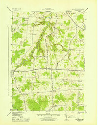
 1940 Port Leyden1940 Print · USGSUpper Lewis County at the start of the 1940s reveals a landscape shaped by the BLACK RIVER and the rail industry. Researchers can trace historic homesteads near Constableville, industrial sites at Goulds Mill, and the riverside Leyden Station PO.
 - 1943 Map of New Boston
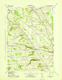
 1943 New Boston1943 Print · USGSLewis County rural life is captured here in the early 1940s, showing a landscape of family-named corners and small crossroads settlements. You can trace family history at Battle Cem, locate the former sites of numerous rural schools, or follow old routes like LACY ROAD.4 unique versions available
 - 1943 Map of West Lowville
 1943 West Lowville1943 Print · USGSLewis County rural life comes into focus in the 1940s, showing a landscape of family farms and local school districts. Researchers can find numerous numbered schoolhouses and cemeteries such as Gallup Cem, Fairview Cem, and the small settlement of Windecker.3 unique versions available
 - 1943 Map of Sears Pond
 1943 Sears Pond1943 Print · USGSLewis County's Tug Hill plateau during the early war years reveals a landscape of isolated rural schools and winding creek networks. Genealogists and historians can trace the foundations of the Hooker settlement and locate vanished schoolhouses like School No 7 and School No 9.5 unique versions available
 - 1943 Map of Page, 1960 Print
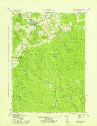
 1943 Page1960 Print · USGSLewis County during the early 1940s shows a landscape of district schools and upland farms near the Tug Hill plateau. Genealogists can locate small settlements like Wetmore and Page or trace the steep terrain around Whetstone Gulf State Park.2 unique versions available
 - 1944 Map of Page
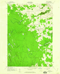
 1944 Page1944 Print · USGSLewis County uplands in the mid-1940s show a landscape of small agricultural hamlets and numbered schoolhouses. Genealogists can trace family footprints around McGraw Corners, Maple Ridge Church, and School No 17.
End of results
Showing maps 1-6 of 6
Top cities near Martinsburg
- Lowville historical maps
- Champion historical maps
- Boonville historical maps
- Lowville historical maps
- Croghan historical maps
- Rutland historical maps
See more
Top neighborhoods of Martinsburg
- West Martinsburg historical maps
- Glenfield historical maps
- East Martinsburg historical maps
- Glendale historical maps
- Wetmore historical maps
Frequently asked questions
- What are the different types of historical maps available for Martinsburg?
- What is the oldest map of Martinsburg?
- Where can I purchase historical maps of Martinsburg for my home or office?
- Where can I download high-res historical maps of Martinsburg?
- Are there historical topographic maps available for Martinsburg?
- Is there historical aerial imagery available for Martinsburg?
- Where are historical maps of Martinsburg sourced from?