
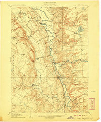
1940 Map of Port Leyden
USGS Topo · Published 1940About this map
The Black River corridor defines the geography of Lewis County in this early 20th-century survey, reprinted at the onset of the 1940s. Industrial and transit hubs such as Port Leyden and Lyons Falls are positioned where the river meets the New York Central and Hudson River railroad, signaling the importance of water power and timber transport. The landscape transitions from the dramatic gorge at Whetstone Gulf to the recreational waters of Brantingham Lake and Little Otter Lake in the east.
Find a feature on this map
60 named features on this map. Tap any name to fly to it.
Don’t see what you’re looking for? This feature index may not catch every label — zoom into the map to look around manually.
Map Details
Editions of this 1940 Port Leyden Map
This is the sole edition of this map. No revisions or reprints were ever made.
Other maps of this area

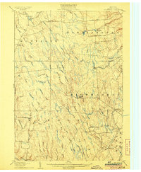
1897 · Remsen
USGS Topo · 1:62,500

1900 · Remsen
USGS Topo · 1:62,500

1902 · Carthage
USGS Topo · 1:62,500

1904 · Boonville
USGS Topo · 1:62,500

1904 · Carthage
USGS Topo · 1:62,500

1905 · Port Leyden
USGS Topo · 1:62,500

1905 · Taberg
USGS Topo · 1:62,500
1906 · Highmarket
USGS Topo · 1:62,500
1907 · Port Leyden
USGS Topo · 1:62,500

1911 · Lowville
USGS Topo · 1:62,500