
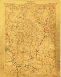
1905 Map of Taberg
USGS Topo · Published 1905About this map
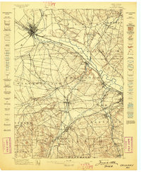
Industrial and agricultural activity across the Oneida-Lewis county line is defined by the heavy presence of milling and rail transport at the start of the 20th century. Water power from the East Branch Fish Creek and its many tributaries, including Fall Brook and Furnace Creek, supported operations like Leisher Mill and Swancott Mill. The settlement of Camden serves as a primary hub where the Lehigh Valley RR meets the New York Central and Hudson River RR, facilitating the movement of timber and goods from the uplands near Osceola. Smaller hamlets like Empeyville East Florence PO and Malone Corner dot the landscape, connected by a network of roads that wind around landmarks such as Wickwire Hill and Pond Hill. The map also illustrates the southern extent of the R W and O Div Oswego and Rome Line passing through Blossvale and Mc Connellsville.
Find a feature on this map
53 named features on this map. Tap any name to fly to it.
Don’t see what you’re looking for? This feature index may not catch every label — zoom into the map to look around manually.
Map Details
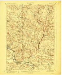
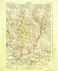
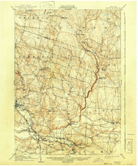
Editions of this 1905 Taberg Map
6 editions found

Other maps of this area

1895 · Chittenango
USGS Topo · 1:62,500

1895 · Oriskany
USGS Topo · 1:62,500

1895 · Oneida
USGS Topo · 1:62,500

1898 · Oneida
USGS Topo · 1:62,500

1898 · Chittenango
USGS Topo · 1:62,500
1898 · Oriskany
USGS Topo · 1:62,500

1902 · Chittenango
USGS Topo · 1:62,500

1902 · Oneida
USGS Topo · 1:62,500

1903 · Orwell
USGS Topo · 1:62,500

1904 · Boonville
USGS Topo · 1:62,500