
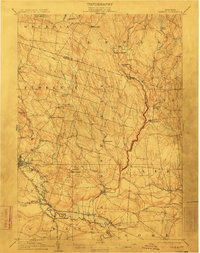
1905 Map of Taberg
USGS Topo · Published 1948About this map
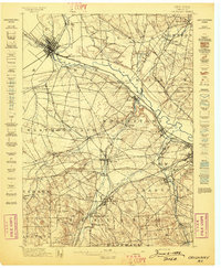
East Branch Fish Creek and its many tributaries, such as Furnace Brook and Fall Brook, dominate this landscape of central New York during the earliest years of the twentieth century. The terrain is characterized by a transition from the agricultural plains of Rome and Vienna in the south toward the more elevation-rich woodlands of Florence and Osceola to the north. Settlement is concentrated around milling and rail access, with Camden serving as a primary hub for the Lehigh Valley RR and the New York Central and Hudson River RR. Scattered rural communities and family-named intersections like Malone Corner and Thomson Corners define the social geography, while specialized industry is visible at Leisher Mill and Swancott Mill. The map also captures local identifiers such as Empeyville (East Florence PO) and the descriptive Bloodsucker Pond.
Find a feature on this map
54 named features on this map. Tap any name to fly to it.
Don’t see what you’re looking for? This feature index may not catch every label — zoom into the map to look around manually.
Map Details
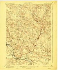
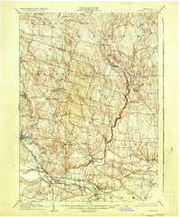
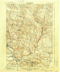
Editions of this 1905 Taberg Map
6 editions found

Other maps of this area

1895 · Chittenango
USGS Topo · 1:62,500

1895 · Oriskany
USGS Topo · 1:62,500

1895 · Oneida
USGS Topo · 1:62,500

1898 · Oneida
USGS Topo · 1:62,500

1898 · Chittenango
USGS Topo · 1:62,500
1898 · Oriskany
USGS Topo · 1:62,500

1902 · Chittenango
USGS Topo · 1:62,500

1902 · Oneida
USGS Topo · 1:62,500

1903 · Orwell
USGS Topo · 1:62,500

1904 · Boonville
USGS Topo · 1:62,500