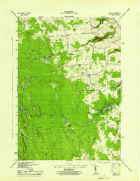
1944 Map of Page
USGS Topo · Published 1944About this map
Page and the surrounding rural uplands of Lewis County are defined by a network of local roads and scattered homesteads during the mid-1940s. The landscape is dotted with several rural institutions, including Maple Ridge Church and numbered schoolhouses such as School No 15 and Sch No 3, which serve the small hamlets of Wetmore, McGraw Corners, and Graves Corners. The terrain is characterized by several significant watercourses, notably Fish Creek, Roaring Brook, and Mad Creek, which carve through the wooded areas and the geologic formations of Flatrock and Keener Hill. This era shows a transition toward organized outdoor recreation with the presence of Whetstone Gulf State Park near the eastern boundary. The intricate drainage patterns of the North Branch and East Branch suggest a region shaped by its heavy woodland and water resources, providing a detailed look at the township boundaries of Martinsburg, Highmarket, and Turin at this time.
Find a feature on this map
34 named features on this map. Tap any name to fly to it.
Don’t see what you’re looking for? This feature index may not catch every label — zoom into the map to look around manually.
Map Details
Editions of this 1944 Page Map
This is the sole edition of this map. No revisions or reprints were ever made.
Other maps of this area

1902 · Carthage
USGS Topo · 1:62,500

1904 · Carthage
USGS Topo · 1:62,500

1905 · Port Leyden
USGS Topo · 1:62,500

1906 · Highmarket
USGS Topo · 1:62,500

1907 · Port Leyden
USGS Topo · 1:62,500

1911 · Lowville
USGS Topo · 1:62,500

1913 · Lowville
USGS Topo · 1:62,500

1940 · Port Leyden
USGS Topo · 1:62,500
1943 · New Boston
USGS Topo · 1:31,680

1943 · West Lowville
USGS Topo · 1:31,680