Old Maps of Livingston County, New York
Explore 177 old maps of Livingston County, spanning from 1900 to today. These high-resolution historic maps reveal how streets, neighborhoods, landmarks, and natural features evolved over time — perfect for genealogy, metal detecting, research, and local history exploration.
What you can do with these maps:
- See how Livingston County changed over time: Compare historical maps to modern-day views to trace roads, homesites, rail lines & more.
- View detailed metadata: Each map includes creators, publishers, year, scale, and archive source.
- Overlay maps with satellite & LiDAR: Visualize the past alongside modern tools to explore terrain & human change.
- Trusted historical sources: Maps sourced from the USGS, Library of Congress, and other archives.
- Access maps your way: View online, download high-res files, or order prints for personal or research use.
Start exploring old maps of Livingston County to uncover forgotten places, hidden landmarks, and the deep history beneath your feet.
Livingston County, NY maps
(177)- 1900 Map of Naples, 1956 Print
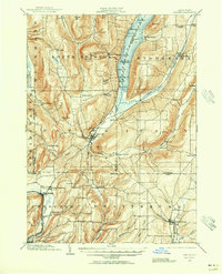 1900 Naples1956 Print · USGSThe Finger Lakes region at the turn of the century shows a landscape of steep ridges and rail-dependent valley towns. Genealogists and historians can trace the vanished tracks of the Kanona and Prattsburg R.R. or locate old community centers like Barker Church and Ingleside.2 unique versions available
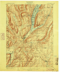
 - 1901 Map of Honeoye, 1954 Print
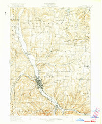
 1901 Honeoye1954 Print · USGSThe Finger Lakes region at the turn of the century was a bustling corridor of milling and rail transit. Genealogists and rail historians can trace the intricate routes of the Lehigh Valley and Erie RR between settlements like Honeoye Falls and Richmond Mills.
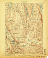
 - 1902 Map of Wayland, 1954 Print
 1902 Wayland1954 Print · USGSThe Finger Lakes region at the turn of the century shows a landscape of steep ridges and critical rail junctions. Genealogists and historians can trace the paths of the Erie RR through Dansville or locate smaller settlements like Perkinsville and Springwater.
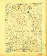
 - 1903 Map of Naples
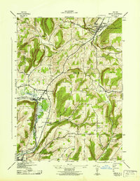
 1903 Naples1903 Print · USGSThe Finger Lakes region at the turn of the century shows a landscape defined by deep valleys and essential transit routes. Trace the old STEAMBOAT ROUTE on Canandaigua Lake or locate early industrial sites like the Naples Tannery and Barker Church.7 unique versions available
 - 1904 Map of Wayland
 1904 Wayland1904 Print · USGSThe western Finger Lakes region in the early 1900s was a bustling corridor of industry and rail. Genealogists and historians can trace the early grid of Dansville, the milling operations at Stones Falls Mill, and the shores of Hemlock Lake.7 unique versions available
 - 1904 Map of Caledonia
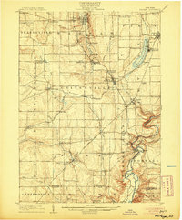
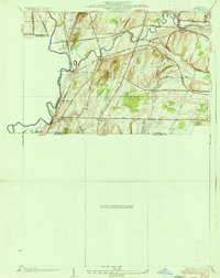
 1904 Caledonia1904 Print · USGSLivingston County and its surrounding borders are shown here at the height of the early railroad era. Researchers can trace the complex rail junctions at Caledonia or locate vanished landmarks and post offices like Wadsworth P.O. S.Greigsville and Retsof.6 unique versions available
 - 1904 Map of Honeoye
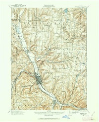
 1904 Honeoye1904 Print · USGSThe Finger Lakes region thrived at the start of the century as a vital rail and milling corridor. Researchers can trace the path of the Electric R. R. and locate family landmarks like Jakman Hill or the old milling sites at Richmond Mills.6 unique versions available
 - 1905 Map of Portage
 1905 Portage1905 Print · USGSWyoming County at the turn of the century shows a landscape defined by the deep gorge of the Genesee River and a busy rail network. Genealogists can trace family names at Halls Corners, explore the Silver Lake Assembly, or locate the mills and stations at Rock Glen and Portageville.6 unique versions available
 - 1905 Map of Nunda
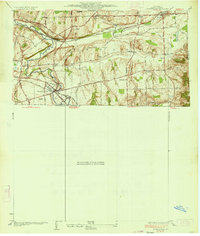
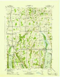
 1905 Nunda1905 Print · USGSLivingston County rail and river life are captured here at the turn of the century, centered on the Genesee River valley. Trace the vanished streets of St Helena, locate the Sonyea P O Craig Colony, and follow the complex rail junctions at Mount Morris.6 unique versions available
 - 1913 Map of Naples
 1913 Naples1913 Print · USGSThe Finger Lakes region at the start of the twentieth century shows a landscape of deep waters and steep ridges connected by steam and rail. Trace the historic Steamboat Route on Canandaigua Lake and follow the rail lines to Naples or Prattsburg.
 - 1915 Map of Hornell, 1962 Print
 1915 Hornell1962 Print · USGSSteuben County was a bustling rail hub when this survey was conducted, featuring a dense network of steam and electric lines. Genealogists can locate dozens of country schoolhouses like Babcock School and Eells School, alongside rural settlements such as Arkport and Haskinville.
 - 1916 Map of Canaseraga
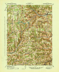
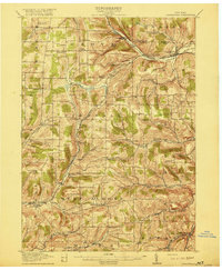 1916 Canaseraga1916 Print · USGSAllegany and Livingston counties appear in the decade before the Great War, during the peak of the local rail era. Genealogists can locate dozens of numbered schoolhouses and family-named landmarks like Whitney Crossings, Karrdale, and the Jersey Hill School.4 unique versions available
 - 1918 Map of Hornell
 1918 Hornell1918 Print · USGSThe rail-and-river corridor of Steuben County comes alive in the years following the Great War. Genealogists can trace family footprints across dozens of country school sites like Dutch Street School and rail hubs from Arkport to Canisteo.6 unique versions available
 - 1934 Map of Rush
 1934 Rush1934 Print · USGSThe Genesee River valley in the 1930s serves as a busy crossroads for major rail lines and rural hamlets. Researchers can trace family homesteads along Martin Road, locate the grounds of School No 6, or map the rail junctions at Golah and West Rush.2 unique versions available
 - 1934 Map of Honeoye Falls
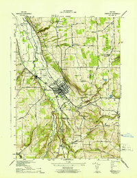
 1934 Honeoye Falls1934 Print · USGSMonroe County and the surrounding valleys are shown here in the 1930s, centered on the village of Honeoye Falls. Local historians can trace early school districts and family plots at Quaker Cem, Graves Cem, and the old rail hub at Rochester Junction.
 - 1940 Map of Canaseraga
 1940 Canaseraga1940 Print · USGSAllegany County's rural township structure is captured here just before the mid-century, showing a landscape tied together by local district schools and the Erie railroad. Researchers can locate early homesteads near Brewer Corners, trace the rail sidings at Garwoods Sta, or find ancestral landmarks like the County House and Jersey Hill School.2 unique versions available
 - 1942 Map of Springwater
 1942 Springwater1942 Print · USGSIn the early 1940s, the Finger Lakes region remained a patchwork of high-elevation farms and valley settlements. Genealogists can trace family names across Tabor Hill and locate long-standing institutions like School No 19 and Mt Vernon Cem.5 unique versions available
 - 1942 Map of Wayland
 1942 Wayland1942 Print · USGSThe intersection of the Erie and Delaware Lackawanna railroads in the early 1940s highlights this busy valley corridor. Genealogists can trace family roots through a dozen numbered schools and named cemeteries like Ashley Cem and St Josephs Cem.
 - 1942 Map of Naples
 1942 Naples1942 Print · USGSSteuben County was a hub of rail traffic and valley farming in the early 1940s. Researchers can trace rural lineages through numerous local landmarks, including Flint Hill Cem, the Flischman Ch, and the dual lines of the Erie RR and D L & W RR.4 unique versions available
 - 1942 Map of Honeoye
 1942 Honeoye1942 Print · USGSThe Finger Lakes region comes to life in the early 1940s as lakeside settlements and hill-country farms define the local landscape. Genealogists and researchers can trace family landmarks like Short Cem, old school districts, and the path of the Lehigh Valley railroad through Hemlock.
 - 1942 Map of Dansville
 1942 Dansville1942 Print · USGSDansville and the surrounding Livingston County uplands are documented here during the early years of the Second World War. Researchers can trace the path of the Delaware Lackawanna and Western RR or locate family sites near Stony Brook State Park and Holy Cross Ch.5 unique versions available
 - 1942 Map of Bristol Springs
 1942 Bristol Springs1942 Print · USGSIn the uplands of Ontario County during the early 1940s, this landscape shows a network of hilltop farms and valley settlements before post-war changes. Researchers can locate several numbered schoolhouses, the Hunt Hollow Cem, and the LEHIGH VALLEY railroad line near Naples.
 - 1942 Map of Conesus
 1942 Conesus1942 Print · USGSLivingston County's eastern uplands and lakeside shores are captured here during the early war years. Researchers can trace the footprints of numerous district schools and small hamlets like Scottsburg or find family history at Lakeview Cem and St Michaels Mission.
 - 1942 Map of Honeoye Falls
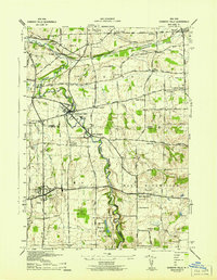 1942 Honeoye Falls1942 Print · USGSWestern New York at the onset of the 1940s reveals a landscape of thriving rail hubs and rural crossroads villages. Genealogists can trace family names through landmarks like Quaker Cem or Graves Cem and locate historic rural schools such as School No 10.
 - 1942 Map of Livonia
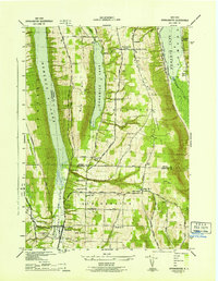
 1942 Livonia1942 Print · USGSConesus Lake's eastern shore and the surrounding uplands are captured here during the early war years. Genealogists and local historians can trace family locations through named sites like Alger Cem, School No 7, and the lakeside Excelsior Springs.
Showing maps 1-25 of 177
Top cities of Livingston County
- Geneseo historical maps
- Livonia historical maps
- Avon historical maps
- North Dansville historical maps
- Mount Morris historical maps
- Lima historical maps
See more
Frequently asked questions
- What are the different types of historical maps available for Livingston County?
- What is the oldest map of Livingston County?
- Where can I purchase historical maps of Livingston County for my home or office?
- Where can I download high-res historical maps of Livingston County?
- Are there historical topographic maps available for Livingston County?
- Is there historical aerial imagery available for Livingston County?
- Where are historical maps of Livingston County sourced from?