1970s Maps of Livingston County, New York
Explore 8 historic maps of Livingston County from the 1970s. These maps offer a rare glimpse into what life looked like during the 1970s — showing old roads, neighborhoods, homes, and landmarks that have changed or disappeared over time.
Whether you're researching your family's past, planning a metal detecting trip, or studying how Livingston County's landscape evolved across the 1970s, these high-resolution maps are a powerful tool for exploring the history of this region.
- Focus on a specific era: All maps on this page are from the 1970s, giving you a focused view of this time period.
- See what’s changed: Compare century-old streets, trails, and buildings to today's modern landscape using overlays and satellite layers.
- Research with precision: Use these maps for genealogy, historical research, land use analysis, or educational projects.
- View, download, or print: Maps are fully viewable online in high resolution, and can be downloaded or printed for your own records.
Start exploring Livingston County's history through authentic maps from the 1970s. This is your window into the past.
Livingston County, NY maps
(8)- 1971 Map of Honeoye Falls, 1973 Print
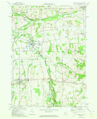 1971 Honeoye Falls1973 Print · USGSThe Monroe and Livingston county borders are defined by the winding course of Honeoye Creek in the early 1970s. Researchers can trace the legacy of the Lehigh Valley tracks, find St Pauls Cem, and locate older settlements like Sibleyville.3 unique versions available
 - 1971 Map of Rush, 1973 Print
 1971 Rush1973 Print · USGSLivingston and Monroe counties come together in the 1970s at the confluence of the Genesee River and Honeoye Creek. Genealogists and local historians can trace family-named sites and vanished rail spurs near Golah, West Rush, and East Avon Cem.3 unique versions available
 - 1972 Map of Nunda, 1974 Print
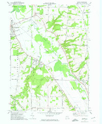
 1972 Nunda1974 Print · USGSLivingston County in the early 1970s shows a landscape of river valleys and rail towns shaped by the Erie-Lackawanna. Genealogists and historians can trace family locations near St Helena Cem, the village of Nunda, and the rural settlement of Barkertown.2 unique versions available
 - 1972 Map of Sonyea, 1974 Print
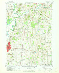
 1972 Sonyea1974 Print · USGSLivingston County in the early seventies shows a landscape of institutional history and river valley rail lines. Genealogists can locate family names at Williamsburgh Cem or trace the grounds of the Craig State School near Sonyea.2 unique versions available
 - 1972 Map of Ossian, 1974 Print
 1972 Ossian1974 Print · USGSThe borderlands of Livingston and Allegany Counties appear here in the early 1970s, showing a landscape of upland forests and quiet hamlets. Genealogists can trace family names through the Ossian Center Cem or locate the Red School and settlements like Byersville.
 - 1972 Map of Portageville, 1974 Print
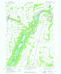
 1972 Portageville1974 Print · USGSThe Genesee River valley in the early 1970s reveals a landscape defined by the falls of Letchworth State Park and rural Wyoming County hamlets. Researchers can trace historic cemeteries and small settlements like Portageville, Mills Mills, and Griffith Corners.3 unique versions available
 - 1972 Map of Mount Morris, 1974 Print
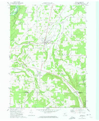
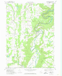
 1972 Mount Morris1974 Print · USGSLivingston County in the early seventies centers on the winding Genesee and the impressive engineering of the Mount Morris Dam. Researchers can trace the Erie-Lackawanna rail corridor and find local landmarks like Glenwood Cem and Brooks Grove.2 unique versions available
 - 1973 Map of Buffalo
 1973 Buffalo1973 Print · USGSWestern New York and Ontario's Golden Horseshoe meet in the early seventies, spanning from the industrial waterfronts of Buffalo to the hills of Allegany State Park. Trace the paths of the Welland Canal and Erie Lackawanna railroad through the lakefront towns of Dunkirk and Port Colborne.
End of results
Showing maps 1-8 of 8
Top cities of Livingston County
- Geneseo historical maps
- Livonia historical maps
- Avon historical maps
- North Dansville historical maps
- Mount Morris historical maps
- Lima historical maps
See more
Frequently asked questions
- What are the different types of historical maps available for Livingston County?
- What is the oldest map of Livingston County?
- Where can I purchase historical maps of Livingston County for my home or office?
- Where can I download high-res historical maps of Livingston County?
- Are there historical topographic maps available for Livingston County?
- Is there historical aerial imagery available for Livingston County?
- Where are historical maps of Livingston County sourced from?