1960s Maps of Livingston County, New York
Explore 8 historic maps of Livingston County from the 1960s. These maps offer a rare glimpse into what life looked like during the 1960s — showing old roads, neighborhoods, homes, and landmarks that have changed or disappeared over time.
Whether you're researching your family's past, planning a metal detecting trip, or studying how Livingston County's landscape evolved across the 1960s, these high-resolution maps are a powerful tool for exploring the history of this region.
- Focus on a specific era: All maps on this page are from the 1960s, giving you a focused view of this time period.
- See what’s changed: Compare century-old streets, trails, and buildings to today's modern landscape using overlays and satellite layers.
- Research with precision: Use these maps for genealogy, historical research, land use analysis, or educational projects.
- View, download, or print: Maps are fully viewable online in high resolution, and can be downloaded or printed for your own records.
Start exploring Livingston County's history through authentic maps from the 1960s. This is your window into the past.
Livingston County, NY maps
(8)- 1960 Map of Buffalo
 1960 Buffalo1960 Print · USGSWestern New York and the Niagara Peninsula thrive during the mid-twentieth century industrial peak. Genealogists and historians can trace family-named points and early settlements from Dunkirk Light to the Allegany Indian Reservation.
 - 1962 Map of Elmira, 1969 Print
 1962 Elmira1969 Print · USGSThe Finger Lakes region and Southern Tier are captured here during a period of industrial maturity and highway expansion. Researchers can trace the path of the Erie Canal, the footprint of the Seneca Army Depot, and legacy rail lines through Elmira and Ithaca.4 unique versions available
 - 1962 Map of Buffalo, 1980 Print
 1962 Buffalo1980 Print · USGSThe Niagara Frontier and Western New York are captured here in the early sixties, showing the vital industrial and maritime nexus between the U.S. and Canada. Researchers can trace the path of the Welland Canal, locate the Allegany Indian Reservation, or find family sites near Chautauqua Lake.2 unique versions available
 - 1964 Map of Conesus
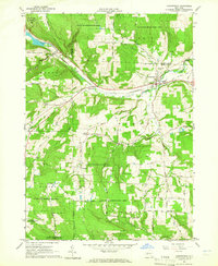
 1964 Conesus1964 Print · USGSThe Finger Lakes region of western New York appears here in the mid-twentieth century, dominated by the southern basin of Conesus Lake. Researchers can trace old family cemetery plots like Clark Cem and vanished rural schoolhouses such as School No 2 or School No 7.
 - 1964 Map of Canaseraga, 1965 Print
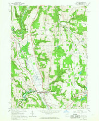
 1964 Canaseraga1965 Print · USGSThe village of Canaseraga and its surrounding ridges appear in detail during the early 1960s, showing a valley shaped by the Erie-Lackawanna Railroad. Researchers can trace old family-named landmarks like Swain Hill and locate rural burial sites such as Bailey Hill Cem.
 - 1965 Map of Elmira
 1965 Elmira1965 Print · USGSThe Finger Lakes and Southern Tier regions are captured in the mid-sixties, showcasing a landscape of deep glacial valleys and heavy rail infrastructure. Trace old railroad corridors like the Pennsylvania RR or visit landmarks like Letchworth State Park and the Seneca Army Depot.
 - 1965 Map of Arkport, 1967 Print
 1965 Arkport1967 Print · USGSThe northern reaches of the Canisteo River valley come to life in the mid-1960s, showing a landscape shaped by rail transport and flood control. Genealogists and historians can trace family locations near Dotys Corners, the Grange Hall, and the marshy expanse of The Muck.3 unique versions available
 - 1967 Map of Buffalo
 1967 Buffalo1967 Print · USGSWestern New York and the Lake Erie shoreline are shown here during the mid-1960s industrial peak. Researchers can trace the massive rail networks of the Erie Railroad, locate the Cattaraugus Indian Reservation, or find historic sites like Fort Erie.
End of results
Showing maps 1-8 of 8
Top cities of Livingston County
- Geneseo historical maps
- Livonia historical maps
- Avon historical maps
- North Dansville historical maps
- Mount Morris historical maps
- Lima historical maps
See more
Frequently asked questions
- What are the different types of historical maps available for Livingston County?
- What is the oldest map of Livingston County?
- Where can I purchase historical maps of Livingston County for my home or office?
- Where can I download high-res historical maps of Livingston County?
- Are there historical topographic maps available for Livingston County?
- Is there historical aerial imagery available for Livingston County?
- Where are historical maps of Livingston County sourced from?