Old Maps of Madison County, New York
Explore 212 old maps of Madison County, spanning from 1895 to today. These high-resolution historic maps reveal how streets, neighborhoods, landmarks, and natural features evolved over time — perfect for genealogy, metal detecting, research, and local history exploration.
What you can do with these maps:
- See how Madison County changed over time: Compare historical maps to modern-day views to trace roads, homesites, rail lines & more.
- View detailed metadata: Each map includes creators, publishers, year, scale, and archive source.
- Overlay maps with satellite & LiDAR: Visualize the past alongside modern tools to explore terrain & human change.
- Trusted historical sources: Maps sourced from the USGS, Library of Congress, and other archives.
- Access maps your way: View online, download high-res files, or order prints for personal or research use.
Start exploring old maps of Madison County to uncover forgotten places, hidden landmarks, and the deep history beneath your feet.
Madison County, NY maps
(212)- 1895 Map of Chittenango
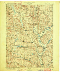
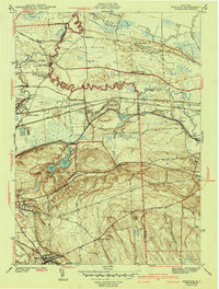
 1895 Chittenango1895 Print · USGSMadison County and the southern shores of Oneida Lake are shown here at the height of the canal and rail era. Researchers can trace the path of the Erie Canal through Chittenango and Canastota or locate vanished sites like Fyler Settlement.
 - 1895 Map of Oneida
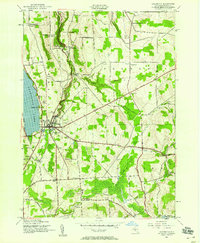
 1895 Oneida1895 Print · USGSIn the 1890s, the landscape around Oneida was a busy hub of canal engineering and railway expansion. Genealogists and historians can trace the evolution of the Erie Canal, find the storied Oneida Community, or locate the historic site of Fort Bull.
 - 1897 Map of Cazenovia, 1953 Print
 1897 Cazenovia1953 Print · USGSMadison and Onondaga Counties are shown here just before the turn of the century, revealing a landscape defined by emerging rail lines and historic hamlets. Researchers can trace family roots through the Cowles Settlement, locate the Constine Bridge, or follow the Lehigh Valley R. R. through Delphi Station.
 - 1898 Map of Oneida
 1898 Oneida1898 Print · USGSCentral New York at the end of the nineteenth century served as a vital crossroads of early American industry and canal technology. Genealogists and historians can trace the footprint of the Oneida Community, the fortifications of Fort Bull, and the intricate paths of the Erie Canal and Old Oneida Lake Canal.
 - 1898 Map of Chittenango
 1898 Chittenango1898 Print · USGSThe northern shore of Oneida Lake and the bustling Erie Canal corridor are captured here during the peak of New York's rail expansion. Researchers can trace the original canal path through Chittenango or locate vanished stops along the West Shore R. R. and Elmira and Cortland Br.
 - 1899 Map of Cazenovia
 1899 Cazenovia1899 Print · USGSMadison and Onondaga Counties are shown here in the late nineteenth century, a landscape defined by emerging lakeside villages and vital railroad junctions. Genealogists can trace early homesteads and hamlets like Cowles Settlement, Quaker Settlement, and Sheds Corners.7 unique versions available
 - 1902 Map of Chittenango
 1902 Chittenango1902 Print · USGSMadison and Onondaga Counties are shown at a peak of rail and canal activity in the early 1900s. Genealogists and historians can trace the path of the Erie Canal through Canastota or locate smaller locales like Fyler Settlement and Quality Hill.7 unique versions available
 - 1902 Map of Morrisville
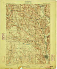
 1902 Morrisville1902 Print · USGSMadison County at the turn of the century was a complex network of upland valleys shaped by the Chenango Canal and three major railroads. Genealogists and historians can trace old homesteads and local infrastructure near Morrisville, Hamilton, and the New York Ontario and Western RR.8 unique versions available
 - 1902 Map of Oneida
 1902 Oneida1902 Print · USGSMadison and Oneida Counties at the turn of the century show a landscape defined by utopian heritage and a complex network of waterways. Genealogists and historians can trace the foundations of the Oneida Community, the path of the Erie Canal, and landmarks like Fort Bull.6 unique versions available
 - 1903 Map of Norwich
 1903 Norwich1903 Print · USGSChenango County at the dawn of the twentieth century was defined by the busy river valleys and rail lines connecting Norwich to Earlville. Researchers can trace the path of the N. Y. O. & W. R. R. through Sherburne Four Corners or locate family-named sites like Irelands Mills and Woods Corners.5 unique versions available
 - 1904 Map of Pitcher
 1904 Pitcher1904 Print · USGSThe rural highlands of Central New York are documented here at the turn of the century, showing a landscape of upland hamlets and river-valley rail lines. Genealogists can trace early homesteads near Pitcher, Cincinnatus, and the remote heights of Taylor Center.5 unique versions available
 - 1907 Map of Winfield
 1907 Winfield1907 Print · USGSCentral New York's dairy and rail corridor is captured here at the start of the century. Genealogists can trace family names across hamlets like Millers Mills and Plainfield Center, or locate old depots along the Unadilla Valley RR.6 unique versions available
 - 1907 Map of Sangerfield
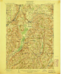 1907 Sangerfield1907 Print · USGSOneida and Madison counties meet at the height of the central New York hills in the early twentieth century. Genealogists and local historians can trace the positions of the Budlong Schoolhouse, the industrial activity at Mains Mills, and the path of the Cherry Valley Turnpike.6 unique versions available
 - 1910 Map of New Berlin, 1963 Print
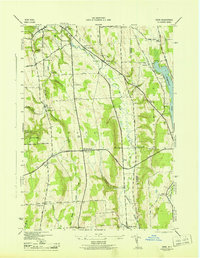
 1910 New Berlin1963 Print · USGSThe Unadilla and Chenango river valleys are seen here in the early twentieth century as established rail corridors and farming hubs. Researchers can trace the N Y O & W R R line through Holmesville or locate family sites like Kings Settlement and the Dimmick Hollow School.
 - 1912 Map of New Berlin
 1912 New Berlin1912 Print · USGSChenango County's river valleys and dairy uplands are meticulously captured in this pre-war survey of the New Berlin area. Genealogists can locate family-named landmarks and institutions like Columbus Hill Church, Kings Settlement, and the Dimmick Hollow School.4 unique versions available
 - 1939 Map of Oneida
 1939 Oneida1939 Print · USGSMadison and Oneida Counties are shown during a period of transition for New York's vital inland waterways and rail lines. Genealogists and historians can trace the paths of the Erie Canal and Old Oneida Lake Canal through settlements like Oneida Castle, Durhamville, and Verona.
 - 1941 Map of Cleveland
 1941 Cleveland1941 Print · USGSOneida Lake’s central waters and the surrounding shorelines are captured here in the early 1940s, highlighting a landscape of rail-connected villages and rural school districts. Genealogists can locate family landmarks like Smith Ridge Cem or trace the path of the New York Ontario and Western RR through Bernhard Bay.2 unique versions available
 - 1941 Map of Jewell
 1941 Jewell1941 Print · USGSOneida Lake shoreline communities in the early 1940s are documented here, showing a mix of established lakeside hamlets and inland farming hubs. Genealogists and local historians can locate early landmarks like Lakeport Chapel, West Church, and the rural Whitelaw Cem.
 - 1942 Map of Oran, 1957 Print
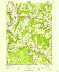
 1942 Oran1957 Print · USGSUpper Onondaga County during the early 1940s is mapped here with a focus on its steep ravines and rural school districts. Genealogists and hikers can trace old property boundaries near Delphi Falls, locate the Indian Hill Memorial, or find family plots like Sharp Cem.
 - 1943 Map of Manlius
 1943 Manlius1943 Print · USGSOnondaga County in the early 1940s reveals a landscape where historic waterways meet modern rail and air infrastructure. Researchers can trace the paths of the Old Erie Canal, locate the Manlius Academy, and explore rural sites like Fyler Settlement.2 unique versions available
 - 1943 Map of Oran
 1943 Oran1943 Print · USGSOnondaga County's rural landscape is captured during the war years, showing a network of small schoolhouses and family cemeteries across the uplands. Genealogists and local historians can trace legacy landmarks like Indian Hill Memorial, Southwell Cem, and the old Manlius Sch.2 unique versions available
 - 1943 Map of Otselic, 1954 Print
 1943 Otselic1954 Print · USGSChenango County hills and valleys are captured here during the 1940s, showing a landscape of upland farms and remote school districts. Genealogists can trace family footprints near Maple Grove Cem or through small crossroads like Stanbro and Bonney.3 unique versions available
 - 1943 Map of New Berlin North, 1957 Print
 1943 New Berlin North1957 Print · USGSChenango and Otsego counties meet along the river in the 1940s, showing a landscape of interconnected valley farms and upland hamlets. Genealogists can trace family sites like Lloyd Cem and Perkinsons Cem or follow the Unadilla Valley River rail line.4 unique versions available
 - 1943 Map of De Ruyter, 1958 Print
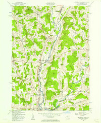
 1943 De Ruyter1958 Print · USGSUpper New York State’s high country at the start of the 1940s shows a landscape of ridge-top farms and valley rail lines. Trace the Lehigh Valley Railroad corridor past De Ruyter Reservoir and find vanished district sites like School No 11 and Cowles Settlement.4 unique versions available
 - 1943 Map of Cazenovia, 1958 Print
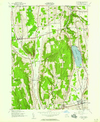
 1943 Cazenovia1958 Print · USGSMadison County at the height of the 1940s reveals a landscape of thriving crossroads and lakeside life. Genealogists and historians can trace family-named sites like Abell Corners, local landmarks like Copstine Bridge, and the historic Welsh Ch.4 unique versions available
Showing maps 1-25 of 212
Top cities of Madison County
- Sullivan historical maps
- Oneida historical maps
- Lenox historical maps
- Cazenovia historical maps
- Hamilton historical maps
- Eaton historical maps
See more
Frequently asked questions
- What are the different types of historical maps available for Madison County?
- What is the oldest map of Madison County?
- Where can I purchase historical maps of Madison County for my home or office?
- Where can I download high-res historical maps of Madison County?
- Are there historical topographic maps available for Madison County?
- Is there historical aerial imagery available for Madison County?
- Where are historical maps of Madison County sourced from?