1900-1909 Maps of Madison County, New York
Explore 7 historic maps of Madison County from 1900-1909. These maps offer a rare glimpse into what life looked like during the 1900s — showing old roads, neighborhoods, homes, and landmarks that have changed or disappeared over time.
Whether you're researching your family's past, planning a metal detecting trip, or studying how Madison County's landscape evolved across the 1900s, these high-resolution maps are a powerful tool for exploring the history of this region.
- Focus on a specific era: All maps on this page are from the 1900s, giving you a focused view of this time period.
- See what’s changed: Compare century-old streets, trails, and buildings to today's modern landscape using overlays and satellite layers.
- Research with precision: Use these maps for genealogy, historical research, land use analysis, or educational projects.
- View, download, or print: Maps are fully viewable online in high resolution, and can be downloaded or printed for your own records.
Start exploring Madison County's history through authentic maps from the 1900s. This is your window into the past.
Madison County, NY maps
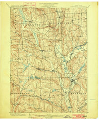
(7)- 1902 Map of Chittenango
 1902 Chittenango1902 Print · USGSMadison and Onondaga Counties are shown at a peak of rail and canal activity in the early 1900s. Genealogists and historians can trace the path of the Erie Canal through Canastota or locate smaller locales like Fyler Settlement and Quality Hill.7 unique versions available
 - 1902 Map of Morrisville
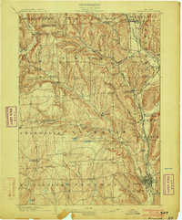
 1902 Morrisville1902 Print · USGSMadison County at the turn of the century was a complex network of upland valleys shaped by the Chenango Canal and three major railroads. Genealogists and historians can trace old homesteads and local infrastructure near Morrisville, Hamilton, and the New York Ontario and Western RR.8 unique versions available
 - 1902 Map of Oneida
 1902 Oneida1902 Print · USGSMadison and Oneida Counties at the turn of the century show a landscape defined by utopian heritage and a complex network of waterways. Genealogists and historians can trace the foundations of the Oneida Community, the path of the Erie Canal, and landmarks like Fort Bull.6 unique versions available
 - 1903 Map of Norwich
 1903 Norwich1903 Print · USGSChenango County at the dawn of the twentieth century was defined by the busy river valleys and rail lines connecting Norwich to Earlville. Researchers can trace the path of the N. Y. O. & W. R. R. through Sherburne Four Corners or locate family-named sites like Irelands Mills and Woods Corners.5 unique versions available
 - 1904 Map of Pitcher
 1904 Pitcher1904 Print · USGSThe rural highlands of Central New York are documented here at the turn of the century, showing a landscape of upland hamlets and river-valley rail lines. Genealogists can trace early homesteads near Pitcher, Cincinnatus, and the remote heights of Taylor Center.5 unique versions available
 - 1907 Map of Winfield
 1907 Winfield1907 Print · USGSCentral New York's dairy and rail corridor is captured here at the start of the century. Genealogists can trace family names across hamlets like Millers Mills and Plainfield Center, or locate old depots along the Unadilla Valley RR.6 unique versions available
 - 1907 Map of Sangerfield
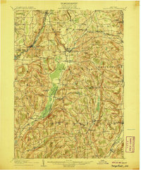 1907 Sangerfield1907 Print · USGSOneida and Madison counties meet at the height of the central New York hills in the early twentieth century. Genealogists and local historians can trace the positions of the Budlong Schoolhouse, the industrial activity at Mains Mills, and the path of the Cherry Valley Turnpike.6 unique versions available
End of results
Showing maps 1-7 of 7
Top cities of Madison County
- Sullivan historical maps
- Oneida historical maps
- Lenox historical maps
- Cazenovia historical maps
- Hamilton historical maps
- Eaton historical maps
See more
Frequently asked questions
- What are the different types of historical maps available for Madison County?
- What is the oldest map of Madison County?
- Where can I purchase historical maps of Madison County for my home or office?
- Where can I download high-res historical maps of Madison County?
- Are there historical topographic maps available for Madison County?
- Is there historical aerial imagery available for Madison County?
- Where are historical maps of Madison County sourced from?