1990s Maps of Nassau County, New York
Explore 4 historic maps of Nassau County from the 1990s. These maps offer a rare glimpse into what life looked like during the 1990s — showing old roads, neighborhoods, homes, and landmarks that have changed or disappeared over time.
Whether you're researching your family's past, planning a metal detecting trip, or studying how Nassau County's landscape evolved across the 1990s, these high-resolution maps are a powerful tool for exploring the history of this region.
- Focus on a specific era: All maps on this page are from the 1990s, giving you a focused view of this time period.
- See what’s changed: Compare century-old streets, trails, and buildings to today's modern landscape using overlays and satellite layers.
- Research with precision: Use these maps for genealogy, historical research, land use analysis, or educational projects.
- View, download, or print: Maps are fully viewable online in high resolution, and can be downloaded or printed for your own records.
Start exploring Nassau County's history through authentic maps from the 1990s. This is your window into the past.
Nassau County, NY maps
(4)- 1994 Map of Jamaica, 2000 Print
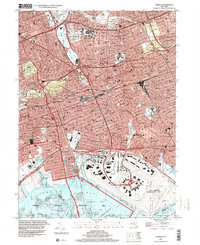 1994 Jamaica2000 Print · USGSCentral Queens in the 1990s reveals a dense network of neighborhoods, major transit corridors, and massive coastal infrastructure. Trace local landmarks from Aqueduct Racetrack and St Johns University to the historic Bayside Cem.
 - 1994 Map of Amityville, 2000 Print
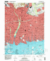 1994 Amityville2000 Print · USGSThe Nassau and Suffolk border in the mid-1990s reveals a landscape defined by rapid suburbanization and major transit arteries. Researchers can trace the layout of Republic Airport, the expansive Pinelawn Cemetery, and the waterfront docks of Amityville.
 - 1994 Map of Freeport, 2000 Print
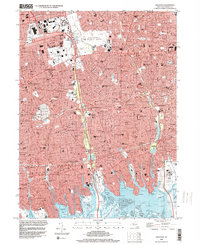 1994 Freeport2000 Print · USGSNassau County suburbanization is in full maturity during the mid-nineties, showing a densely settled landscape from Hempstead to the South Shore. Researchers can trace local landmarks like Roosevelt Raceway, Greenfield Cemetery, and the U S Military Reservation.
 - 1995 Map of Flushing, 1999 Print
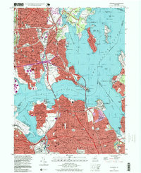 1995 Flushing1999 Print · USGSThe coastal stretches of the Bronx and Queens are captured here in the mid-nineties, showing the dense residential growth and massive bridge infrastructure of the era. Researchers can trace historic institutions and local landmarks like Shea Stadium, Fort Totten Mil Reservation, and St Raymonds Cemetery.
End of results
Showing maps 1-4 of 4
Top cities of Nassau County
- Hempstead historical maps
- Oyster Bay historical maps
- North Hempstead historical maps
- Long Beach historical maps
- Glen Cove historical maps
- New Hyde Park historical maps
See more
Frequently asked questions
- What are the different types of historical maps available for Nassau County?
- What is the oldest map of Nassau County?
- Where can I purchase historical maps of Nassau County for my home or office?
- Where can I download high-res historical maps of Nassau County?
- Are there historical topographic maps available for Nassau County?
- Is there historical aerial imagery available for Nassau County?
- Where are historical maps of Nassau County sourced from?