Old Maps of Queens, New York for Hiking & Exploration
Hike through history with 74 historic maps of Queens. Explore old trails, ghost towns, and forgotten backroads — perfect for outdoor adventurers and local explorers.
- Rediscover forgotten places: Map out old mining camps, roads, and footpaths that no longer exist on modern maps.
- Layer with modern tools: Combine with LiDAR or satellite views to plan hikes through historical terrain.
- Made for exploration: Popular among hikers, overlanders, and local history lovers.
Use these maps to find adventure and explore the hidden past of Queens.
Queens, New York maps
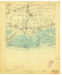
(74)- 1889 Map of Brooklyn
 1889 Brooklyn1889 Print · USGSCovers Queens, including New York, Hempstead, and other nearby areas
 - 1891 Map of Brooklyn
 1891 Brooklyn1891 Print · USGSCovers Queens, including New York, Hempstead, and other nearby areas
 - 1891 Map of Harlem
 1891 Harlem1891 Print · USGSCovers Queens, including New York, North Hempstead, and other nearby areas
 - 1897 Map of Harlem, 1956 Print
 1897 Harlem1956 Print · USGSCovers Queens, including New York, North Hempstead, and other nearby areas4 unique versions available
 - 1897 Map of Brooklyn, 1959 Print
 1897 Brooklyn1959 Print · USGSCovers Queens, including New York, Hempstead, and other nearby areas3 unique versions available
 - 1897 Map of Hempstead, 1961 Print
 1897 Hempstead1961 Print · USGSCovers Queens, including New York, Hempstead, and other nearby areas
 - 1897 Map of Oyster Bay, 1963 Print
 1897 Oyster Bay1963 Print · USGSCovers Queens, including New York, Hempstead, and other nearby areas
 - 1898 Map of Harlem
 1898 Harlem1898 Print · USGSCovers Queens, including New York, North Hempstead, and other nearby areas
 - 1898 Map of Hempstead
 1898 Hempstead1898 Print · USGSCovers Queens, including New York, Hempstead, and other nearby areas
 - 1898 Map of Staten Island
 1898 Staten Island1898 Print · USGSCovers Queens, including New York, Newark, and other nearby areas
 - 1898 Map of Brooklyn
 1898 Brooklyn1898 Print · USGSCovers Queens, including New York, Hempstead, and other nearby areas
 - 1898 Map of Oyster Bay
 1898 Oyster Bay1898 Print · USGSCovers Queens, including New York, Hempstead, and other nearby areas
 - 1899 Map of Hempstead
 1899 Hempstead1899 Print · USGSCovers Queens, including New York, Hempstead, and other nearby areas
 - 1900 Map of Passaic
 1900 Passaic1900 Print · USGSCovers Queens, including New York, Newark, and other nearby areas
 - 1900 Map of Staten Island
 1900 Staten Island1900 Print · USGSCovers Queens, including New York, Newark, and other nearby areas10 unique versions available
 - 1900 Map of Harlem
 1900 Harlem1900 Print · USGSCovers Queens, including New York, North Hempstead, and other nearby areas16 unique versions available
 - 1900 Map of Brooklyn
 1900 Brooklyn1900 Print · USGSCovers Queens, including New York, Hempstead, and other nearby areas11 unique versions available
 - 1900 Map of Oyster Bay
 1900 Oyster Bay1900 Print · USGSCovers Queens, including New York, Hempstead, and other nearby areas15 unique versions available
 - 1903 Map of Hempstead
 1903 Hempstead1903 Print · USGSCovers Queens, including New York, Hempstead, and other nearby areas9 unique versions available
 - 1905 Map of Passaic
 1905 Passaic1905 Print · USGSCovers Queens, including New York, Newark, and other nearby areas4 unique versions available
 - 1942 Map of Passaic
 1942 Passaic1942 Print · USGSCovers Queens, including New York, Newark, and other nearby areas
 - 1944 Map of Newark, 1971 Print
 1944 Newark1971 Print · USGSCovers Queens, including New York, Philadelphia, and other nearby areas5 unique versions available
 - 1947 Map of Brooklyn
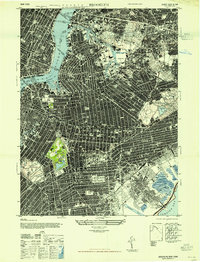 1947 Brooklyn1947 Print · USGSCovers Queens, including New York, Kings County, and other nearby areas
 - 1947 Map of Sea Cliff
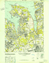 1947 Sea Cliff1947 Print · USGSCovers Queens, including New York, Oyster Bay, and other nearby areas
 - 1947 Map of Jamaica
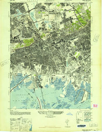 1947 Jamaica1947 Print · USGSCovers Queens, including New York, Hempstead, and other nearby areas
Showing maps 1-25 of 74
Frequently asked questions
- What are the different types of historical maps available for Queens?
- What is the oldest map of Queens?
- Where can I purchase historical maps of Queens for my home or office?
- Where can I download high-res historical maps of Queens?
- Are there historical topographic maps available for Queens?
- Is there historical aerial imagery available for Queens?
- Where are historical maps of Queens sourced from?